Buldhana is a City and a Municipal Council in the Indian state of Maharashtra. Established on 17 February 1893. It is the Administrative headquarters of the Buldhana District of Amravati division. It is the Second largest City in the district after Khamgaon and a popular place as a hill station because the city is surrounded by the mountainous area in the Ajanta range. Buldhana is around 552 km away from the state capital Mumbai. Buldhana has many religious, historical and tourist places around it like Balaji Temple in rajur ghat a replica of popular Balaji Temple of South India, is a famous religious and tourist place within city limits, Shri Gajanan Maharaj Temple in Shegaon around 75 km away, the World Famous Lonar Crater a National Geo-heritage monument created by meteorite impact is almost 100 km from city of Buldhana, Rajmata Jijau birthplace Sindkhed Raja is 90 km, Sailani Baba Dargah a major attraction of Buldhana just 25 km away from the city, The World Heritage Site Ajanta Caves is just 55 km away from the City and Dnyanganga Wildlife Sanctuary in Botha Forest is also just 20 km away from the city and many more tourist places are there around Buldhana City.

Birwadi is a census town in Raigad district in the state of Maharashtra, India.
Dhatav is a Village in Roha Taluka in Raigad district in the state of Maharashtra, India. Dhatav connected through Mumbai & Pune through Mumbai Goa Highway in kolad
Dyane is a census town in Nashik district in the state of Maharashtra, India.
Kalundre is a census town in Raigad district in the Indian state of Maharashtra.
Kandri is a census town in Nagpur district in the Indian state of Maharashtra.
Kasara is a census town in Thane district in the Indian state of Maharashtra. The town is on the busy Mumbai–Nashik route, which is one of the four major routes that lead into Mumbai. Kasara is served by a railway station on the Mumbai Suburban Railway, and is the final stop in the north-east sector of the Central Line and important railway station. That is for abbreviation for Kasara Local is set as "N" means North side Local's Last Station. Town is also known for the winding Thal Ghat or better known as Kasara Ghats.
Kegaon is a census town in Raigad district in the Indian state of Maharashtra. Uran is the nearest town. The village which is on the western coast of Maharashtra overlooks the metropolis of Mumbai. The town is served by road from Uran, and boat from the port of Mora which connects to the Gateway of India and Ferry Wharf in Mumbai.
Manadur is a census town in Sangli district in the Indian state of Maharashtra.
Mohopada, alias Wasambe, is a census town in Khalapur Taluka, Raigad district in the Indian state of Maharashtra.
Rajur is a census town in Yavatmal district in the Indian state of Maharashtra. Rajur is also known as Rajur Colliery.
Roha Ashtami is a twin city and a municipal council in the Raigad district in the Indian state of Maharashtra.
Soyagaon or soegaon is a Town and Taluka in Nashik District in the Indian state of Maharashtra.
Surgana is a census town and taluka in Nashik District in the Indian state of Maharashtra.

Taloja is a census town in Raigad district of Navi Mumbai city in the Indian state of Maharashtra. It is an extension of the Kharghar node and governed by Panvel Municipal Corporation. Taloja has Navi Mumbai Metro Phase I starting origin point at Pendhar. Taloja is divided into two phases as Phase I and Phase II by CIDCO. CIDCO has developed mass housing project in Taloja Phase II and development work is in progress. Taloja is connected to other parts of Navi Mumbai through Indian Railways, Navi Mumbai Metro & NMMT buses. Taloja is going to be connected soon by the new international airport, Navi Mumbai International Airport(NMIA).
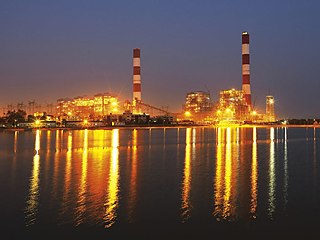
Tirora is a city and a municipal council in Gondia (Gondiya) district of Maharashtra, India. Adani Power Maharashtra Limited, Tirora is the largest coal based Thermal Power Plant in the state of Maharashtra, India. The plant has a capacity to generate 3300 MW power through its 5 units of 660 MW capacity each.
Utekhol is a census town in Raigad district in the Indian state of Maharashtra.
Pali is a census town in Raigad District in the Indian state of Maharashtra.
Kalamb is a town with a municipal council in Osmanabad district in the Indian state of Maharashtra. Administratively it is part of and headquarters for the Kalamb Tehsil.
Khed is a census town in Satara district in the Indian state of Maharashtra.

