This article needs additional citations for verification .(February 2016) (Learn how and when to remove this template message) |
Awalan is a small village located in Mahabaleshwar taluka of Satara district.
This article needs additional citations for verification .(February 2016) (Learn how and when to remove this template message) |
Awalan is a small village located in Mahabaleshwar taluka of Satara district.
Awlan has total 48 families residing. The village has population of 173 of which 85 are males while 88 are females as per Population Census 2011. Average Sex Ratio of village is 1035 which is higher than Maharashtra state average of 929. Literacy rate of village was 62.89 % compared to 82.34 % of Maharashtra. In Awalan Male literacy stands at 80.00 % while female literacy rate was 47.62 %. [1] Awalan has substantial population of Schedule Caste. Schedule Caste (SC) constitutes 29.48 % of total population in village. The village currently doesn’t have any Schedule Tribe (ST) population. [1]
Awlan village is located at 17.54°N 73.91°E.[1] It has an average elevation of 560 metres (1200 ft) and .
Located about 150 km (95 mi) southwest of Pune and 340 km (210 mi) from Mumbai, Awalan is a vast plateau measuring 150 km2 (58 sq mi), bound by valleys on all sides. It reaches a height of 1,439 m (4,721 ft) at its highest peak above sea level, known as Uteshwar Temple
Awalan comprises four wadis: Manewadi, Khalchiwadi, Varchiwadi, and Baudhwadi.
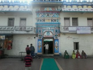
Village has temple of Bhairi Kumbalaj which was rebuilt in 2014. Awlan has people of various caste and religion, common surnames in Awlan are Sakpal, Shelar, Mane, More, Pawar and Kamble. As village is located beside [Koyana dam|Koyana]] river, it is also known as "Water village". In every Marathi month of Paush a cultural festival is organized in village which is based on local goddess.[ citation needed ]

Mahabaleshwar is a small town and a municipal council in Satara district in the Indian state of Maharashtra.It is a place of pilgrimage for Hindus because the Krishna river has its origins here. The British colonial rulers developed the town as a hill station, and served as the summer capital of Bombay Presidency during the British Raj.
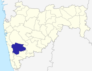
Satara district is a district of Maharashtra state in western India with an area of 10,480 km² and a population of 3,003,741 of which 14.17% were urban. Satara is the capital of the district and other major towns include Wai, Karad, Koregaon, Dahiwadi, Koynanagar, Rahimatpur, Phaltan, Mahabaleshwar, Vaduj and Panchgani. This district comes under Pune Administrative Division along with Pune, Sangli, Solapur and Kolhapur. The district of Pune bounds it to the north, Raigad bounds it to the north-west, Solapur the east, Sangli to the south, and Ratnagiri to the west.

Aurad is a historical city located in Bidar district in the Kalyana-Karnataka region of the Indian state of Karnataka. It is famous for 10th century Shree Amareshwar temple. It is birthplace of MP, Bhagwanth Khuba.

Ganj Dundawara is a city and a municipal board in Kasganj District and the Aligarh zone in the state Uttar Pradesh, India.

Pathri is a town and a municipal council in Parbhani district in the Indian state of Maharashtra. Chief Minister of Maharashtra Mr. Uddhav Thakre has confirmed that Pathri is the real birthplace of Sai Baba and he has allocated Rs 1 billion for the development of Pathri. This will help boost the economy of Pathri and Prabhani District. Pathri Premier League (PPL) is a popular annual cricket tournament organised in the city to boost local cricketing talent.
Poladpur is a census town in Raigad district in the Indian state of Maharashtra.

Samba is a Municipal Committee city in the only sub-district "Samba Tahsil" of the Samba District in the Indian Union territory of Jammu and Kashmir. With a population of about 12,700, Samba is the third least populous municipal committee in the district. Its total Density of population is 2, and it is the second smallest city by area in the sub district. The city is divided into 13 wards for which elections are held every 5 years. Among the 13 wards, Samba Ward No. 13 is the most populous ward with a population of 1702, and Samba Ward No. 11 is the least populous ward with a population of 533.
Pokharni is a village ,located in the Parbhani District of the Marathawada region of Maharashtra State of India. It is known for a temple dedicated to Narasimha.
Khandala is a taluka in the Satara district in Maharashtra, India. The Nira River passes through the region. Khandala Taluka is situated on the northern side of Satara district. Khandala, Shirwal and Lonand are large towns in the taluka. Khandala got separated from Wai Taluka along with Mahabaleshwar for easier administration. The Nira River flows from the northern border of the taluka. "VEER" is the largest dam on the Nira River in Khandala. The southern border is covered with "MAHADEVACHE DONGAR", meaning Mahadev Hills.

Dhom Dam, is an earthfill and gravity dam on Krishna river near Wai in state of Maharashtra in India.
Belthara Road is a Nagar Panchayat city with a railway station in the north-western corner of Ballia district of Uttar Pradesh, India.
Zari is a major village in Parbhani taluka of Parbhani district of Maharashtra state in India.
Charthana is a major village in Jintur taluka of Parbhani district in Maharashtra state of India. It used to be known as Charukshetra Nagari in the name of king Charudatta. There are near about 360 temples of Mahadeva, some of which are under the ground. The Archaeological Survey of India (ASI) has acquired the remaining temples for conservation. Gokuleshwar mandir, Barav, Dwipmal, and Nartirtha are places of interest among many others.
Palam is a town and a headquarter of Palam taluka. It's located in Parbhani district which is part of State of Maharashtra in India.
Walur is a major village in Sailu taluka of Parbhani district in Maharashtra state of India. Walur is also famous for ancient valmiki rishi temple placed in center of the village. There are some unconfirmed stories/ truths about the presence of valmiki rishi in walur. The stories states that before being known as valmiki rishi he was not aware of his abilities of writing and was not a devotee of lord RAMA. As guided by narada, valmiki started chanting word 'MARA' and after few years the word turned out as 'RAMA'. Huge anthills formed around valmiki rishi and then he got name of VALMIKI. The unconfirmed stories from this area states valmiki rishi chanted the name of RAMA in Walur and anthill formed around him. As anthill means warul in marathi language the name of village was inspired by it. Before some year the name warul turned out as Walur.
Bhogaon is a major village in Jintur taluka of Parbhani district in Maharashtra state of India.
Asegaon is a village in Jintur taluka of Parbhani district of Indian state of Maharashtra. It is 27 km away from Parbhani city while it is 26 km away from Jintur. There is a Digambar Jain temple in the village.
Karawadi is a village panchayat located in the Karad taluka of Satara district in the southern part of Indian state of Maharashtra. It belongs to Western Maharashtra region. It has a population of 3,588 according to 2011 census. The nearby villages include Ogalewadi, Viravade, Wagheri. Prominent family surnames include Pisal, Patil, Chavan, Bhosale, More, Bansode, Dubal. It is in the Pune Division. It is located 57 km towards South from District headquarters Satara and 278 km from State capital Mumbai.

Ninam is a census village in Satara district, in the Indian state of Maharashtra. It is a village surrounded by greenery and farms but also mountains. Agriculture is the main land use in the village with more than 75% of the total area being used for agricultural activities. The village close to historic Ajinkyatara fort, which is to the north. The large Jyotirlinga temple is in the center of the village.

Old Mahabaleshwar is a historical place and a village in Mahabaleshwar, Satara district in the Indian state of Maharashtra. It is a hill station located in the Western Ghats range.Old Mahabaleshwar is also known as "Kshetra Mahabaleshwar". Old Mahabaleshwar is about 7 km from Mahabaleshwar. This holy and sacred place has 3 temples: Panchganga temple, Mahabaleshwar temple and Krishna temple.