Mahabaleshwar is a small town and a municipal council in Satara district, Maharashtra, India. It is a place of pilgrimage for Hindus because Krishna river has its origin here. The British colonial rulers developed the town as a hill station, and served as the summer capital of Bombay Presidency during the British Raj.
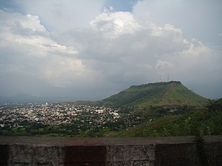
Satara is a city located in the Satara District of Maharashtra state of India, near the confluence of the river Krishna and its tributary, the Venna. The city was established in the 16th century and was the seat of the Chhatrapati of Maratha Empire, Shahu I. It is the headquarters of Satara Tehsil, as well as the Satara District. The city gets its name from the seven forts (Sat-Tara) which are around the city. The city is known as a Soldier's city as well as Pensioner's city.

Pratapgad is a large, mountain fort located in Satara district, in the Western Indian state of Maharashtra. The fort is situated on a mountain 24 kilometres from the Mahabaleshwar hill station. The fort is now a popular tourist destination.

Mahad is a city in Raigad district situated in the North Konkan region of Maharashtra state, India. It is located 108.5 km (67.4 mi) from District's headquarter Alibag, and 167 km (104 mi) from Mumbai, the state capital of Maharashtra and economic capital of India, towards western coast. Mahad is home to Raigad Fort, the capital of the Maratha Empire in Shivaji's era and revolutionary Mahad Satyagraha launched by at Chavdar Tale in the wake of modern India.

Ratangad is a fort in Ratan Wadi, Maharashtra, India, overlooking the locale of Bhandardara, one of the oldest artificial catchment area. This fort is located in the Ahmadnagar district of Maharashtra. It is on the boundary of Ahmadnagar and Thane districts. The fort is about 400 years old. This fort is often covered with flowering plants in November. Ratangad is also called Jewel of the Sahyadris.
Kamalgad, also called Bhelanja or Kattalgad is a square hill fort in Wai Taluka in Maharashtra, India.

Ambenali Ghat is a mountain road in Maharashtra, India cutting across the Northern Western Ghats or the Sahyadri mountain range. It connects the coastal Raigad District Konkan region of Maharashtra with the Satara District Desh region on the Deccan plateau. It is one of few link roads between the Konkan and Ghatmaatha in Maharashtra. The road, state highway 72, is at an average elevation of 625 m (2,051 ft). The ghat, or mountain road, is about 40 km long. Its characteristic feature is that it takes many turns without gaining/losing much height. It links the cities of Poladpur and Mahabaleshwar. It ends in Poladpur. The road ascends/descends around 1300m from Mahabaleshwar to Poladpur. It is the longest ghat in Maharashtra.This ghat travels through the Javali forest area. Many animals like leopards are seen here. This 40 km long ghat is known for its deadly road, where many accidents take place. It is very scenic and its picturesque landscape makes it an ideal location for tourists who flock around the ghat in crowds.

Rohida fort / Vichitragad Fort is a fort located 10 km from Bhor, Pune district, of Maharashtra. This fort is an important fort in Pune district. The fort restoration is done by the Shree Shivdurga Samvardhan committee with the help of forest dept. and local villagers.

Kenjalgad Fort in Wai, Maharashtra is a fort eleven miles (18 km) north-west of Wai. It is located on the Mandhardev spur of the Mahadev hill range. The fort is visible from quite a long distance as a stone scarp 30–40 feet high rising as a cap on the irregular hill. The fort is rhomboid in shape with 388m long axis and 175m short axis.

Ghangad is a fort situated near 30km from Lonavla-Khandala and 100 km from Pune in Maharashtra state, India.This fort is an important fort in the Pune district. The fort restoration is done by the Shivaji Trail group with the help of local villagers. The fort is at least 300 years old. Restoration work took place in 2011-12.

Harihar fort / Harshagad is a fort located 40 km from Nashik City, 48 km from Igatpuri, 40 km from Ghoti in Nashik district, of Maharashtra, India. It is an important fort in Nashik district, and was constructed to look upon the trade route through Gonda Ghat. It receives many visitors because of its peculiar rock-cut steps.

Peb Fort / Vikatgad Fortis a fort located 19km from Karjat, in Raigad district, of Maharashtra. This fort is in continuation with the Malang gad, Tauli Hill and Chanderi fort of the Matheran Hill Range. Vikatgad is a favourite destination for one-day trekkers. The trek path to Vikatgad is along deep ravines and cliffs. Its closeness to Matheran and Neral attracts many trekkers on weekends. The forest department and local villagers are doing plantation and some restoration works on the fort.
Rajdeher Fort (Marathi: राजधेर किल्ला) is a fort located 10 km (6.2 mi) from chandwad, Nashik district, of Maharashtra. This fort is an important fort in Nashik district.
Ahivant Fort is a fort located 55km from Nashik, in Nashik district, of Maharashtra. This fort is an important fort in Nashik district. The three forts Achala, Ahivant, and Mohandar are very close by. The other two forts were constructed to guard the Ahivant fort.
Achala Fort is a westernmost fort in the Satmala hill range. It is located 55km from Nashik, in Nashik district, of Maharashtra. This fort is adjoining the Ahivant Fort. The three forts Achala, Ahivant, and Mohandar are very close by. The Achala and Mohandar forts were constructed to guard the Ahivant fort. Captain Briggs has described it as a large hill, whose ascent is very easy till it reaches the top where it is very steep.

Shivgad Fort is a fort located 89km from Kolhapur, in Kolhapur district, of Maharashtra. This fort was an important fort in Kolhapur district as a watch over for the Phonda ghat trade route from Kolhapur to coastal ports. The fort is surrounded by thick forest and hill slopes.
Konkandiva Fort (transliteration: Konkandiva Qilа̄) is a fort located 70 km from Pune in Maharashtra. This fort is on the boundary of Raigad and Pune district. The fort was important as a surveillance fort to keep watch on the possible attack on the Raigad fort through Ghol Village side along the Mutha river.
Kurdugad Fort is a fort located 143 km (89 mi) from Mumbai and 113km from Pune in Raigad district, of Maharashtra. This fort was an important fort in Raigad district as a watch over for the trade route from Pune to coastal ports. The fort is surrounded by thick forest and hill slopes.

Mohandar Fort / Shidaka fort is a fort located 55 km from Nashik, in Nashik district, of Maharashtra, India. This fort is an important fort in Nashik district. The three forts Achala, Ahivant, and Mohandar are very close by. This fort was constructed to guard the Ahivant fort. This fort can be seen from a long distance due to the presence of needle hole in the cliff below this fort.
