Kalsubai is a mountain in the Western Ghats, located in the Indian state of Maharashtra. Its summit, situated at an elevation of 1,646 metres (5,400 ft), is the highest point in Maharashtra.

Harishchandra Fort is a hill fort in the Ahmednagar district of India. Its history is linked with that of Malshej Ghat, kothale village and it has played a major role in guarding and controlling the surrounding region.
Sudhagad / Bhorapgad is a hill fort situated in Maharashtra, India. It lies about 53 kilometres (33 mi) west of Pune, 26 kilometres (16 mi) south of Lonavla and 11 kilometres (6.8 mi) east of Pali in Raigad District. The summit is 620 metres (2,030 ft) above sea level. The entire area around the fort is declared a Sudhagad wildlife sanctuary.
Wada or Vada is one of the eight talukas of the Palghar district in the Konkan division of Maharashtra state in India. Centuries ago wada taluka known as kamalpur It is one of the most industrialised talukas in Palghar district.
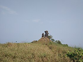
Madangad is a fort in the Nashik region of Maharashtra, India in the Kalsubai range.

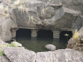
Irshalgad is a fortress located between Matheran and Panvel in Maharashtra, India. It is a sister fort to Prabalgad. The area of the fort is not large but there are several water cisterns cut from the rock. The nearest village is Irshalwadi.

Alang Fort is a fort located in the Kalsubai range of the Western Ghats mountains, Nashik,. Alang Fort, Madangad Fort, Kulang Fort, and the trek connecting them are known as Alang, Madan, and Kulang (AMK). Alang Fort is regarded as one of the most difficult places to reach in the region. As the Maharashtra Culture Government website notes, "Alang-Madan-Kurland is one of Maharashtra's most challenging treks, especially because of its challenging stretches of water and dense forests." This route is suitable for experienced mountaineers. While the forts are difficult to access because of heavy local rains and poorly marked trails, they remain a popular tourist destination.

Brahmagiri is a mountain range in the Western Ghats of Maharashtra. It is situated in Nashik District in the Indian state of Maharashtra. Trimbakeshwar Shiva Temple is located near this place. The origin of the sacred Godavari river is near Trimbak. It flows for 1,465 kilometres (910 mi), first eastwards across the Deccan Plateau then turns southeast, entering the West Godavari district and East Godavari district of Andhra Pradesh, until it splits into two watercourses that widen into a large river delta and flow into the Bay of Bengal.

Tandulwadi Fort is located near Saphale, 104 km north of Mumbai. Tandulwadi is not a fully built up fort, but a series of structures spread over the top of the mountain. The fort dates back 800 years and was primarily used as a watch tower over the surrounding plains. At a height of 1524 feet, it has views of the surrounding towns of Saphale, the Zanzorli lake, and the confluence of the Surya and Vaitarna rivers.

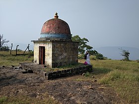
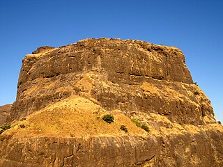
Ankai Fort is a historic site found in the Satmala Range hills in western India. It is located in Yeola Taluka of Nashik district in the state of Maharashtra. The fort was built by Yadava of Devgiri. Geographically, it is near Manmad. The Ankai fort and Tankai fort are two different forts on adjacent hills. A common fortification is constructed to secure both. The Ankai fort is located on a hill with perpendicular scarps on all the sides, except for a narrow nose on the eastern side.

Ghangad is a fort situated near 30km from Lonavla-Khandala and 100 km from Pune in Maharashtra state, India.This fort is an important fort in the Pune district. The fort restoration is done by the Shivaji Trail group with the help of local villagers. The fort is at least 300 years old. Restoration work took place in 2011-12.

Surgad, is a hill fort located in a spur, fragmented from the Sahyadri ranges of Maharashtra. The fort is situated near Roha, next to the village of Gherasurgad in the Raigad district. This fort was an observation fort, which guarded the trade route along the Kundalika river from Sudhagad to Revdanda fort.

Peb Fort / Vikatgad Fortis a fort located 19km from Karjat, in Raigad district, of Maharashtra. This fort is in continuation with the Malang gad, Tauli Hill and Chanderi fort of the Matheran Hill Range. Vikatgad is a favourite destination for one-day trekkers. The trek path to Vikatgad is along deep ravines and cliffs. Its closeness to Matheran and Neral attracts many trekkers on weekends. The forest department and local villagers are doing plantation and some restoration works on the fort.

Asheri Fort / Asheri is a fort located 102 km from Mumbai and 88 km from Thane. It is in Palghar district, of Maharashtra. This fort is an important fort in Palghar district. The fort is located on the hills near Mendhavan Khind on Mumbai-Ahmedabad highway. The base village Khodkona is a very small tribal village. The Fort restoration is done by the local villagers.

Gambhirgad Fort is a fort located 58 km from Dahanu, Palghar district, of Maharashtra. This fort is less important fort in Palghar district. The fort is in ruins and restoration is to be done.
Bhupatgad Fort is a fort in Palghar district in the Jawhar taluka in Maharashtra state of India.
Bitangad Fort is a fort in Nashik district in the Igatpuri taluka in Maharashtra state of India.
Kurdugad Fort is a fort located 143 km (89 mi) from Mumbai and 113km from Pune in Raigad district, of Maharashtra. This fort was an important fort in Raigad district as a watch over for the trade route from Pune to coastal ports. The fort is surrounded by thick forest and hill slopes.
Takmak Fort is located in Palghar taluka of Palghar district in Maharashtra. The fort is situated on a north-south hill spur ending in a steep rise. The fort is in a ruined state with few remains of fortification. This is a fort located 60 km (37 mi) from the city of Mumbai. For some time, this fort was in the possession of the Portuguese and it was captured by Maratha army after the Battle of Vasai in 1739. It was captured by British Army in 1817.
Pabargad Fort is a fort located 50 km (31 mi) from Igatpuri via Bhandardara. The fort is in Akole taluka in Ahmednagar district, of Maharashtra. The trek to this fort is difficult.