Ghangad

Last updated
Ghanagad Fort
घनगड
Part of Sahyadri Hill Range
Pune district, Maharashtra
Ghanagad.jpg
Ghanagad fort
India Maharashtra location map.svg
Red pog.svg
Ghanagad Fort
Coordinates 18°32′44.7″N73°21′34.5″E / 18.545750°N 73.359583°E / 18.545750; 73.359583
TypeHill fort
Height3000 Ft.
Site information
OwnerGovernment of India
Open to
the public
Yes
ConditionRuins
Site history
MaterialsStone

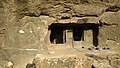
Ghangad is a fort situated near 30km from Lonavla-Khandala and 100 km from Pune in Maharashtra state, India.This fort is an important fort in the Pune district. The fort restoration is done by the Shivaji Trail group with the help of local villagers. The fort is at least 300 years old. [1] Restoration work took place in 2011-12. [2]

Contents

History

Very less information is available about the history of the fort. This fort was used for keeping prisoners and for keeping watch on the trade route from Pune to Konkan. Until 1818 this fort was under the Maratha empire. This fort was surrendered to British forces after the fall of Korigad on 17-March-1818. [3]

How to reach

The fort can be reached by road via Tamhini ghat road or via Lonavla. The nearest town is Lonavla which is 30km from the base village of the fort i.e. Ekole. There are good hotels at Lonavla, now tea and snacks are also available in small hotels on the way at Peth Shahapur. The road becomes rugged in the Saltar pass. The trekking path starts from the hillock south of the Ekole village. The route is very safe and wide. There is a dense forest on the trekking route. It takes about half an hour to reach the entrance gate of the fort. The night stay on the fort can be made on the flat ground near the entrance or GarjaiDevi temple on the way to Fort. This fort is approachable in all seasons. The villagers from the Ekole make night stay and food arrangements at reasonable rates.

Places to see

There are two gates on the fort. The main entrance gate has the arch missing. The villagers have placed an iron ladder to climb to the Balekilla of the fort. There is a rock cut water cistern on the way to the second gate. The water is available round the year for drinking purpose. It takes about an hour to visit all places on the fort. There are remains of few dilapidated building on the Balekilla. The top of the bale killa gives a scenic view of the TailBaila, Korigad, Mulshi dam and Sudhagad fort

See also

Related Research Articles

Shivneri Fort Fort in Maharashtra, India

Shivneri Fort is a 17th-century military fortification located near Junnar in Pune district in Maharashtra, India. It is the birthplace of Shivaji, the emperor and founder of Maratha Empire.

Harishchandragad Fort in Maharashtra State, India

Buddhist Caves is a hill fort in the Ahmednagar district of India. Its history is linked with that of Malshej Ghat, kothale village and it has played a major role in guarding and controlling the surrounding region.

Tikona Fort in Pune district, Maharashtra, India

Tikona also known as Vitandgad) is the dominant hill fort in Maval in western India. It is located near Kamshet around 60 km from Pune. The village nearest to the fort is called Tikona-Peth. The 3500 foot high hill is pyramidal in shape and the name Tikona means "triangular".

Sudhagad

Sudhagad / Bhorapgad is a hill fort situated in Maharashtra, India. It lies about 53 kilometres (33 mi) west of Pune, 26 kilometres (16 mi) south of Lonavla and 11 kilometres (6.8 mi) east of Pali in Raigad District. The summit is 620 metres (2,030 ft) above sea level. The entire area around the fort is declared a Sudhagad wildlife sanctuary.

Rajmachi Village in Maharashtra

Rajmachi Fort (Killa) is one of the many historical forts in the rugged hills of Sahyadri mountains. It consists of two twin fortresses Shriwardhan and Manaranjan, with a wide machi (plateau) surrounding the two Balekillas. Udhewadi is a small village of about 60 households situated on the machi, at the southern foot of Manaranjan Balekilla of Rajmachi Fort.

Kamalgad

Kamalgad, also called Bhelanja or Kattalgad is a square hill fort in Wai Taluka in Maharashtra, India.

Korigad

Korigad is a hill fort located about 20 km (12 mi) south of Lonavla in Pune district, Maharashtra, India. Its date of construction is not known but likely predates 1500. It is about 923 m above sea level. The planned township of Aamby Valley is built over the fort's southern and eastern foothills. The closest village is Peth Shahpur, about 1 km (0.62 mi) north of the fort.

Ramsej Fort

Ramsej or Ramshej Fort is a small fort located 10 kilometres (6.2 mi) north-west of Nashik, in the Indian state of Maharashtra. Lord Rama stayed in the fort for a short time while traveling to Sri Lanka. The fort is located on the Nashik-Vapi route.

Rohida fort

Rohida fort / Vichitragad Fort is a fort located 10 km from Bhor, Pune district, of Maharashtra. This fort is an important fort in Pune district. The fort restoration is done by the Shree Shivdurga Samvardhan committee with the help of forest dept. and local villagers.

Harihar fort Fort in Maharashtra, India

Harihar fort / Harshagad is a fort located 40 km from Nashik City, 48 km from Igatpuri, 40 km from Ghoti in Nashik district, of Maharashtra, India. It is an important fort in Nashik district, and was constructed to look upon the trade route through Gonda Ghat. It receives many visitors because of its peculiar rock-cut steps.

Indrai fort Historic building in Maharashtra, India

Indrai Fort / Indragiri Fort is a fort located 75 km from Nashik, in Nashik district, of Maharashtra. This fort though is an important fort in Nashik district but, it is less visited by the trekkers. In Chandwad taluka, there are 4 forts in a line on the Satmal hill range, the Chandwad fort, Indrai fort, Rajdher fort, and Koldher fort. This fort is easy to climb but requires 3 hours to reach the fort.

Vikatgad

Peb Fort / Vikatgad Fortis a fort located 19km from Karjat, in Raigad district, of Maharashtra. This fort is in continuation with the Malang gad, Tauli Hill and Chanderi fort of the Matheran Hill Range. Vikatgad is a favourite destination for one-day trekkers. The trek path to Vikatgad is along deep ravines and cliffs. Its closeness to Matheran and Neral attracts many trekkers on weekends. The forest department and local villagers are doing plantation and some restoration works on the fort.

Rajdher fort

Rajdeher Fort (Marathi: राजधेर किल्ला) is a fort located 10 km (6.2 mi) from chandwad, Nashik district, of Maharashtra. This fort is an important fort in Nashik district.

Asheri fort Fort in India

Asheri Fort / Asheri is a fort located 102 km from Mumbai and 88 km from Thane. It is in Palghar district, of Maharashtra. This fort is an important fort in Palghar district. The fort is located on the hills near Mendhavan Khind on Mumbai-Ahmedabad highway. The base village Khodkona is a very small tribal village. The Fort restoration is done by the local villagers.

Gorakhgad

Gorakhgad Fort is a fort located 24 km from Murbad, Thane district, of Maharashtra. This fort is an important fort in Thane district. This fort was mainly used by sadhus or hermits for meditation.and also by local people's of surrounding village, It was also used to guard the ancient trade route passing through Naneghat.

Ahivant Fort is a fort located 55km from Nashik, in Nashik district, of Maharashtra. This fort is an important fort in Nashik district. The three forts Achala, Ahivant, and Mohandar are very close by. The other two forts were constructed to guard the Ahivant fort.

Hatgad Fort is a fort located 71 km (44 mi)from Nashik, Nashik district, of Maharashtra. The base village is Hatgad on the Nashik-Saputara Road. The nearest town is Saputara, which is 6 km from Hatgad village. It is a historic monument located in Maharashtra, India, south of the hill station of Saputara and near the border with Gujarat. It was built by the Maratha king Shivaji and is located at an elevation of about 3,600 feet. The way to reach the fort is through a trekking route via a narrow rocky path and car also go up to the stairs of fort. A statue of Lord Shivling is placed on the top of the fort.

Gambhirgad

Gambhirgad Fort is a fort located 58 km from Dahanu, Palghar district, of Maharashtra. This fort is less important fort in Palghar district. The fort is in ruins and restoration is to be done.

Ghargad Fort / Gadgada Fort is a fort located 145 km from Mumbai, in Nashik district, of Maharashtra. This fort is less visited fort in Nashik district. This fort is quiet difficult to climb.

Konkan Diva Fort Ancient Indian fort

Konkandiva Fort (transliteration: Konkandiva Qilа̄) is a fort located 70 km from Pune in Maharashtra. This fort is on the boundary of Raigad and Pune district. The fort was important as a surveillance fort to keep watch on the possible attack on the Raigad fort through Ghol Village side along the Mutha river.

References

  1. "Rajasthan to Junnar: Deccan College plans a host of excavationsRajasthan to Junnar:". Times of India. 10 November 2014. Retrieved 14 April 2016.
  2. Swamy, Rohan (28 November 2011). "Road To Recovery". The Indian Express. Retrieved 14 April 2016.
  3. https://gazetteers.maharashtra.gov. in/cultural.maharashtra.gov.in/english/gazetteer/Poona%20District/places_k.html#.