This article needs additional citations for verification .(January 2008) |
Rajmachi Udhewadi | |
|---|---|
village | |
 Rajmachi Fort | |
 | |
 Rajmachi Location in Maharashtra, India  Rajmachi Rajmachi (India) | |
| Coordinates: 18°49′33″N73°23′44″E / 18.825799°N 73.3955267°E | |
| Country | |
| State | Maharashtra |
| District | Pune District |
| Talukas | Maval |
| Languages | |
| • Official | Marathi |
| Time zone | UTC+5:30 (IST) |
| Nearest city | Lonavala |
| Lok Sabha constituency | Lonavala |

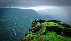
Rajmachi Fort (Killa) is a historical fort in the hills of the Sahyadri mountains (Western Ghats). [1] It consists of two twin fortresses Shriwardhan and Manaranjan, with a wide machi (plateau) surrounding the two Balekillas. Udhewadi is a small village of about 60 households (as per 2011 census report) situated on the machi, at the southern foot of Manaranjan Balekilla of Rajmachi Fort. [2]
