Kataldhar Lonavla

Last updated
A view from Rajmachi of Kataldhar Waterfall before monsoon Kataldhar Waterfall from Rajmachi.jpg
A view from Rajmachi of Kataldhar Waterfall before monsoon
Eye Shaped Cave Behind Kataldhar Waterfall.jpg
Eye Shaped Cave

Kataldhar is a waterfall near Lonavala in Pune district in the Indian state of Maharashtra. This waterfall is not so famous because reaching the valley is somewhat difficult and requires basic trekking experience. Water is not available there for the whole year, but a good amount of water falls during the monsoon season.

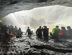
Kataldhar Waterfall is located near Rajmachi Fort. To get there, find 3 mango trees on the Rajmachi Trekking route, at which point you can descend the Ulhas valley through dense forest. After reaching Kataldhar Waterfall you will see one eye shaped cave that could easily accommodate 100 people. At this cave, you will see Rajmachi Fort (Srivardhan Fort Balekilla). [1]

The height of Kataldhar Lonavla is about 350 feet with an overhand of more than 100 feet. [2]

Related Research Articles

Lonavala Hill station in Maharashtra, India

Lonavala is a hill station town and a Municipal Council in the Pune district, Maharashtra, India. It is about 64 km west of Pune and 96 km to the east of Mumbai. It is known for its production of the hard candy chikki and is also a major stop on the railway line connecting Mumbai and Pune. From the Pune suburbs, local trains are available from Pune Junction. Both the Mumbai-Pune Expressway as well as the Mumbai-Bengaluru highway pass through Lonavala.

Khandala Hill station in Maharashtra, India

Khandala is a hill station in the Western Ghats in the state of Maharashtra, India, about 3 kilometres (1.9 mi) from Lonavala, 12 kilometres from Khopoli and 33.4 kilometres (20.8 mi) from Karjat.

Harishchandragad Fort in Maharashtra State, India

Buddhist Caves is a hill fort in the Ahmednagar district of India. Its history is linked with that of Malshej Ghat, kothale village and it has played a major role in guarding and controlling the surrounding region.

Bhandardara Village in Maharashtra, India

Bhandardara is a holiday resort village near Igatpuri, in the western ghats of India. The village is located in the Akole tehsil, Ahmednagar district of the state of Maharashtra, about 185 kilometers (115 mi) from Mumbai and 155 kilometers (96 mi) from Ahmednagar.

Lohagad Fort in Maharashtra, India

Lohagad is one of the many hill forts of Maharashtra state in India. Situated close to the hill station Lonavala and 52 km (32 mi) northwest of Pune, Lohagad rises to an elevation of 1,033 m (3,389 ft) above sea level. The fort is connected to the neighboring Visapur fort by a small range. The fort was under the Maratha empire for the majority of the time, with a short period of 5 years under the Mughal empire.

Sudhagad

Sudhagad / Bhorapgad is a hill fort situated in Maharashtra, India. It lies about 53 kilometres (33 mi) west of Pune, 26 kilometres (16 mi) south of Lonavla and 11 kilometres (6.8 mi) east of Pali in Raigad District. The summit is 620 metres (2,030 ft) above sea level. The entire area around the fort is declared a Sudhagad wildlife sanctuary.

Akole is a city and Taluka in Akole tehsil, Ahmednagar district in the state of Maharashtra, India. Akole is surrounded by the Sahyadri Mountains of Western Ghats, India. Several historical sites in the city honor Akole's connection to the history and culture of Maharashtra.

Rajmachi Village in Maharashtra

Rajmachi Fort (Killa) is one of the many historical forts in the rugged hills of Sahyadri mountains. It consists of two twin fortresses Shriwardhan and Manaranjan, with a wide machi (plateau) surrounding the two Balekillas. Udhewadi is a small village of about 60 households situated on the machi, at the southern foot of Manaranjan Balekilla of Rajmachi Fort.

Kothaligad

Kothaligad is a small fort (3100 ft) situated to the east of Karjat near Karjat-Murbad Road in the Indian state of Maharashtra. It is a famous trek in the Karjat area, because of its small height and easy climbing. It is also known as the Fort of Peth because of its vicinity to Peth village at its base.

Visapur Fort Fort in Pune district, Maharashtra, India

Visapur Fort is a hill fort near Visapur village in Maharashtra, India. It is a part of the Lohagad-Visapur fortification.

Korigad

Korigad is a hill fort located about 20 km (12 mi) south of Lonavla in Pune district, Maharashtra, India. Its date of construction is not known but likely predates 1500. It is about 923 m above sea level. The planned township of Aamby Valley is built over the fort's southern and eastern foothills. The closest village is Peth Shahpur, about 1 km (0.62 mi) north of the fort.

Shrivardhan Fort Hill Fort in Maharashtra, India

Shrivardhan Fort is one of the two hill forts that constitute the Rajmachi fortification, the other being Manaranjan Fort. It is located in Rajmachi village which 8.5 km from Lonavala in the Sahyadris mountain range. At 900 m(3000 feet) above sea level it was the taller of the two peaks and was named after Shrivardhan Ganpatrao Patwardhan. Other than a rampart there is no visible construction. It was probably used at a watchtower for the Sahyadri region. There are two water tanks at the top of the hill but one of them has an iron pillar in it.

Manaranjan fort is one of the two hill forts that constitute the Rajmachi fortification, the other being Shrivardhan Fort. It is located in Rajmachi village which 8.5 km from Lonavala in the Sahyadris mountain range. Manaranjan fort is 2700 feet high which makes it lower than the neighbouring Shreevardhan fort. It has three gates and large ramparts. From here Karnala fort can be seen. There are some water tanks at the summit.

The Kune Falls is a waterfall at Lonavla in Pune district in the Indian state of Maharashtra. It is the 14th highest waterfall in India.

Lonavala railway station

Lonavala railway station is a railway station in Lonavala, a hill station in the state of Maharashtra in India. Lonavala station is the origin of Lonavala–Pune Suburban Trains. 17 suburban trains operate on the Pune–Lonavala route. Lonavla is also a halt for Mumbai–Pune Express and Mail trains. The Karjat–Pune passenger train also has a halt at Lonavala. Trains traveling on the Kalyan–Pune route also halt at Lonavala. This station leads access to Lonavala town and nearby areas like Karla Caves, Bhaja Caves, Lohagad, Visapur Fort, Bhushi Dam and Bhor Ghat. Khandala hill station is just 8 kilometres (5.0 mi) from Lonavla.

Alang Fort Indian fort

Alang Fort is a fort located in the Kalsubai range of the Western Ghats mountains, Nashik,. Alang Fort, Madangad Fort, Kulang Fort, and the trek connecting them are known as Alang, Madan, and Kulang (AMK). Alang Fort is regarded as one of the most difficult places to reach in the region. As the Maharashtra Culture Government website notes, "Alang-Madan-Kurland is one of Maharashtra's most challenging treks, especially because of its challenging stretches of water and dense forests." This route is suitable for experienced mountaineers. While the forts are difficult to access because of heavy local rains and poorly marked trails, they remain a popular tourist destination.

Tandulwadi Fort

Tandulwadi Fort is located near Saphale, 104 km north of Mumbai. Tandulwadi is not a fully built up fort, but a series of structures spread over the top of the mountain. The fort dates back 800 years and was primarily used as a watch tower over the surrounding plains. At a height of 1524 feet, it has views of the surrounding towns of Saphale, the Zanzorli lake, and the confluence of the Surya and Vaitarna rivers.

Ghangad

Ghangad is a fort situated near 30km from Lonavla-Khandala and 100 km from Pune in Maharashtra state, India.This fort is an important fort in the Pune district. The fort restoration is done by the Shivaji Trail group with the help of local villagers. The fort is at least 300 years old. Restoration work took place in 2011-12.

Mrugagad

Mrugagad fort is a hill fort in Sudhagad taluka of Raigad district, Maharashtra, India. At a height of 1750 ft, the fort lies near Bheliv village, and is made of stone. The fort is very small in size and is in a form of spur radiating from the Western ghats. The fort is very close to the Lonavala, Khandala and Khopoli.

Devkund Waterfall Waterfall in Maharashtra, India

Devkund Waterfall is a waterfall located near Bhira, in Raigad district, Maharastra, India. It is a 'plunge' waterfall pouring massive amounts of water on the rocky surface underneath. It is a popular spot for one day picnics.

References

  1. "Kataldhar waterfall near Lonavala @699". Trekhievers. Retrieved 13 August 2022.
  2. "Katal Dhar | Lonavla | The secluded waterfall | Travel Blog Trek" . Retrieved 29 May 2020.

  1. How to Reach Rajmachi and Kataldhar Waterfalls in Maharashtra http://shepherdtraveller.com/rajmachi/