Ratnagiri is a port city on the Arabian Sea coast in Ratnagiri District in the southwestern part of Maharashtra, India. The district is a part of Konkan division of Maharashtra. The city is known for the Hapus or Alphonso mangoes. Ratnagiri is the birthplace of Lokmanya Tilak. Thibaw, The king of Burma was exiled in the city.

Ratnagiri District is a district in the state of Maharashtra, India. The administrative headquarter of the district is located in the town of Ratnagiri. The district is 11.33% urban. The district is bounded by the Arabian Sea to the west, Sindhudurg district to the south, Raigad district to the north and Satara, Sangli and Kolhapur districts to the east. This district is part of Konkan division.

Ganpatipule (Gaṇpatīpuḷē) is a small town located 25 km north of the city of Ratnagiri in Ratnagiri district on the Konkan coast of Maharashtra, in the sub-continent of India. The town of Chiplun is located to its north.
Sindhudurg district is an administrative district of the Konkan division in India, which was carved out of the erstwhile Ratnagiri district. The district headquarters are located at Oros and the district occupies an area of approximately 5,207 km2 and has a population of 849,651, of which 12.59% were urban. As of 2011, it's the least populous district of Maharashtra.

Khed is a town with a municipal council in the Ratnagiri district of the state of Maharashtra, India. Situated on the Mumbai - Ratnagiri Highway, NH 66, it is surrounded by a number of villages.
Raigad district, previously known as Kolaba district, is a district in the Konkan division of Maharashtra, India.
Sawantwadi is a taluka in the Sindhudurg district in the Indian state of Maharashtra. The taluka headquarters is Sawantwadi which has a municipal council, which is a local civic body. Sawantwadi was formerly the capital of the Kingdom of Sawantwadi, ruled by the Sawant Bhonsle royal clan of the Marathas.
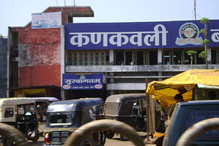
Kankavli is a city in Sindhudurg district in the Indian state of Maharashtra. It is an important city due to its central location in the Sindhudurg district. All talukas are at an equal distance from Kankavli city. There is a temple of Shri Bhalchandra Maharaj and Swyambhu Ravalnath. The Kankavli city is situated in between two west flowing rivers which carry roaring gushing waters on their rockbed to Arabian sea in monsoon. It is a culturally, educationally and socially rich and vibrant major city. A veteran Gandhian Shri Appasaheb Patwardhan founded Gopuri Ashram near Kankavli city with principles of Swadeshi, Swatchhata, Swawlamban and Sarvodaya in 1948. Kankavli is equally located from Kolhapur and Ratnagiri. This is one of the important railway stations on Konkan railway route and major towns on NH 66. Maharashtra's ex- Chief Minister Shri. Narayan Rane also hails from this area.

Karad is a city in Satara district of Indian state of Maharashtra and it is 320 km (180.19 miles) from Mumbai and 159 km from Pune. It lies at the confluence of Koyna River and the Krishna River known as the "Priti sangam". The two rivers originate at Mahabaleshwar, which is around 100 km from Karad. They diverge at their origin, and travel for about the same distance to meet again in Karad. The rivers meet exactly head on, thus forming letter "T" which is the only head on confluence in the world. Hence Krishna and Koyna river's confluence is called Preeti Sangam, meaning Confluence of Love. Karad is well known for sugar production and is known as the sugar bowl of Maharashtra owing to the presence of many sugar factories in and around Karad. It is considered as an important educational hub in Western Maharashtra due to the presence of many prestigious educational institutes. This place is also known for resting place or (Samadhi) of the first chief minister of Maharashtra Shri. Yashwantrao Chavan situated at the confluence of Krishna and Koyana river.

Ambajogai previously Mominabad municipal council, Tehsil and subdivision in Beed district in the state of Maharashtra, India. It was renamed as Mominabad in 1903. This change was reverted in 1962.
Mandangad is the headquarters of Mandangad taluka the northmost taluka in Ratnagiri district of Maharashtra, India.
Shirshi is a village in Kokan on the banks of the Jagbudi River. The village falls under the jurisdiction of the Khed Taluka of Ratnagiri.
Bhoo is a small village situated in Rajapur Taluka, Ratnagiri district of Maharashtra, India. Its population totals less than 1000. Situated eight kilometres northwest of Rajapur, it is connected to it and to Ratnagiri by bus.
Ashti is a small village on the banks of the Jagbudi River in the region of the Western Ghats (also known as the Sahyadri mountains, in the Indian state of Maharashtra. It is located in the Khed taluka of Ratnagiri district, and is 17 km from the town of Khed.
Saitavde, or Saitawada, is a small village on the Jaigad creek in Ratnagiri district. It is about 390 km southwest of Mumbai, and about 58 km to the north of Ratnagiri city.
Shringartali is a large village in the Guhagar Taluka region of Ratnagiri in the Indian state of Maharashtra. It is situated between Chiplun and Guhagar. The economy of Guhagar boomed after the RGPPL was commissioned in 1990. Agriculture includes alphanso mangoes (hapus), harvested from March to the end of May, and are distributed to Mumbai. It is the capital of Guhagar. Major businesses and educational institutes are located here. The town is on Guhagar-Bijapur highway.
Satawali is a census town in Lanja-Taluka Ratnagiri district in the Indian state of Maharashtra.

Rameshwar also known as Rameshwar Wadi is a small town located on the coast of Sindhudurg District of Maharashtra on the west coast of India. A very old Shri Dev Rameshwar Temple is located in this town which is dedicated to the Hindu deity Shiva.

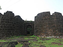
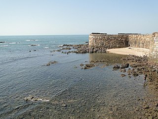
Vijaydurg Port is a natural harbour on the west coast of the district of Sindhudurg in Maharashtra, India. The port is situated midway between Malvan and Ratnagiri at the mouth of the Vijaydurg creek in Devgad taluka. Its coastal jurisdiction extends 10 km north up to the Jaitapur lighthouse. Goods weighing about 200 tons are generally loaded or unloaded at the port daily. The cargo brought by sea is transported by creek up to Kharepatan which is 26 miles up from Vijayadurg.
Umberghar is a small village located at coast of Vashisthi River(Dabhol Khadi) in Ratnagiri district in the state of Maharashtra in India. It is 256 km away from the state capital of Mumbai.