Kalsubai is a mountain in the Western Ghats, located in the Indian state of Maharashtra. Its summit, situated at an elevation of 1,646 metres (5,400 ft), is the highest point in Maharashtra.

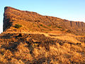
Harishchandragad is a hill fort in the Ahmednagar district of India. Its history is linked with that of Malshej Ghat, kothale village and it has played a major role in guarding and controlling the surrounding region.
Igatpuri is a town and a Hill Station. It is also a municipal council in Nashik District in the Indian state of Maharashtra. It is located in the Western Ghats. Igatpuri railway station lies in Nashik District between Mumbai and Nashik Road on the Central Railway. Igatpuri is known for Vipassana International Academy, where ancient technique of meditation is taught called Vipassana. The place is one of the best places to visit in Maharashtra in monsoon. It is a hill station on busy Mumbai-Agra NH-3 only 45 km from Nashik and 130 km from Mumbai.

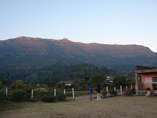
Bhandardara is a holiday resort village near Igatpuri, in the western ghats of India. The village is located in the Akole tehsil, Ahmednagar district of the state of Maharashtra, about 185 kilometers (115 mi) from Mumbai and 155 kilometers (96 mi) from Ahmednagar.

Ratangad is a fort in Ratan Wadi, Maharashtra, India, overlooking the locale of Bhandardara, one of the oldest artificial catchment area. This fort is located in the Ahmadnagar district of Maharashtra. It is on the boundary of Ahmadnagar and Thane districts. The fort is about 400 years old. This fort is often covered with flowering plants in November. Ratangad is also called Jewel of the Sahyadris.
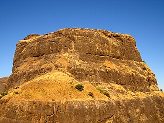
Madangad is a fort in the Nashik region of Maharashtra, India in the Kalsubai range.
Bhairavgad fort is located in the Sahyadri mountains of the Indian state of Maharashtra. Multiple mountains are named Bhairavgad including one near the Karad-Chiplun area, one near Malshej Ghat and third in the Bhandardara region in the neighborhood of Ghanchakkar the third highest peak of Sahyadris.

Brahmagiri is a mountain range in the Western Ghats of Maharashtra. It is situated in Nashik District in the Indian state of Maharashtra. Trimbakeshwar Shiva Temple is located near this place. The origin of the sacred Godavari river is near Trimbak. It flows for 1,465 kilometres (910 mi), first eastwards across the Deccan Plateau then turns southeast, entering the West Godavari district and East Godavari district of Andhra Pradesh, until it splits into two watercourses that widen into a large river delta and flow into the Bay of Bengal.

Satmala (pronunciation:[sɐtmaːla]) is a mountain range which runs across Nashik District, Maharashtra. They are an integral part of the Sahyadris range within Nashik. These peaks are visible from a greater part of the district and form prominent landmarks. The highest of them is Dhodap. Dhodap hill is the third highest hill peak in Maharashtra after Kalsubai and Salher and 29th highest peak in the Western Ghats. At the eastern side of this range lies the Chandvad range. There is a range with the same name Satmala in Telangana.
Darna is a minor right-bank tributary of Godavari in the Nashik District, Maharashtra. Rising north of the Kalsubai range, it drains Igatpuri, Nashik and Niphad Talukas of Nashik District. The conjunction with Godavari is situated at Darnasangvi.

Ankai Fort is a historic site found in the Satmala Range hills in western India. It is located in Yeola Taluka of Nashik district in the state of Maharashtra. Geographically, it is near Manmad. The Ankai fort and Tankai fort are two different forts on adjacent hills. A common fortification is constructed to secure both. The Ankai fort is located on a hill with perpendicular scarps on all the sides, except for a narrow nose on the eastern side.

Tringalwadi fort is located in the Igatpuri taluka of Nashik district. It is located on the ancient trade route passing through Thal ghat. The fort is located near village Tringalwadi. The Tringalwadi irrigation dam which is close to the village was built in 1978

Kulang fort is located in the Igatpuri area of Nashik district, on the western side of the Kalsubai hill range. This fort is adjacent to the Madangad and Alang forts, all of which were constructed to protect the Nashik-Kalyan ancient commercial road.

Bhaskargad fort / Basgad Fort is a fort located 48 km from Igatpuri, Nashik district, of Maharashtra. This fort is one of the fort in Trimbak hill range. This fort is near to the Harihar fort.

Harihar fort / Harshagad is a fort located 40 km from Nashik City, 48 km from Igatpuri, 40 km from Ghoti in Nashik district, of Maharashtra, India. It is an important fort in Nashik district, and was constructed to look upon the trade route through Gonda Ghat. It receives many visitors because of its peculiar rock-cut steps.

Peb Fort / Vikatgad Fortis a fort located 19km from Karjat, in Raigad district, of Maharashtra. This fort is in continuation with the Malang gad, Tauli Hill and Chanderi fort of the Matheran Hill Range. Vikatgad is a favourite destination for one-day trekkers. The trek path to Vikatgad is along deep ravines and cliffs. Its closeness to Matheran and Neral attracts many trekkers on weekends. The forest department and local villagers are doing plantation and some restoration works on the fort.

Ghargad Fort / Gadgada Fort is a fort located 145 km from Mumbai, in Nashik district, of Maharashtra. This fort is less visited fort in Nashik district. This fort is quiet difficult to climb.
Bitangad Fort is a fort in Nashik district in the Igatpuri taluka in Maharashtra state of India.
Dermal Fort is a fort located 125 mi (201 km) from Nashik, in the Nashik district of Maharashtra, India. Though this fort is an important fort in Nashik district, it is less visited by trekkers. In Satana taluka, there are four forts in a line on the Galna hill range, the Pisola fort, Dermal fort, Kankrala fort and Galna fort. This fort is easy to climb but requires two hour to reach the fort. There are very few remains of old buildings on the fort.
Pabargad Fort is a fort located 50 km (31 mi) from Igatpuri via Bhandardara. The fort is in Akole taluka in Ahmednagar district, of Maharashtra. The trek to this fort is difficult.