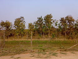
Garchuk Lachit Garh

Last updated • 1 min readFrom Wikipedia, The Free Encyclopedia

Garchuk Lachit Garh
Part of Assam
Guwahati, Assam, India
Garh Garhchuck.jpg
Garchuk fort, Guwahati
Type Fort
Site information
Controlled by Government of Assam
Condition Ruins
Site history
Built16th-17th century
Built by Ahom kingdom
Materials Granite Stones and lime mortar
Battles/wars Ahom–Mughal conflicts

Garchuk Lachit Garh (meaning 'fort' in Assamese) or Fort, now popularly known as Lachit Garh, is located in northeastern India in the southwestern part of Guwahati city to the west of Ahomgaon. The fort was constructed under the Ahom kingdom during the times of Lachit Borphukan around the year 1670 CE, and stretches from the northern Fatasil hills at Garchuk locality cutting across the National Highway (N.H.)-37 at Garchuk Charali to the southern hills via Pamahi and Moinakhurung. The length of the fortification is about 3 km.

The fortification was built centuries ago to deter the Mughal cavalry with two earthen ramparts and two water filled lakes in between and ditches dug in front, which can be seen by visitors. But illegal encroachment has taken its toll on this heritage site.

Related Research Articles

Battle of Saraighat 17th century battle in Assam

The Battle of Saraighat was a naval battle fought in 1671 between the Mughal Empire, and the Ahom Kingdom on the Brahmaputra river at Saraighat, now in Guwahati, Assam, India. Although weaker, the Ahom Army defeated the Mughal Army by brilliant uses of the terrain, clever diplomatic negotiations to buy time, guerrilla tactics, psychological warfare, military intelligence and by exploiting the sole weakness of the Mughal forces—its navy.

North Guwahati Neighbourhood in Kamrup Rural district, Assam, India

North Guwahati is northern part of the city of Guwahati and a town area committee in Kamrup Rural district in the Indian state of Assam.This town abounds in historical places and picnic spots. National Highway 27 passes through North Guwahati. Amingaon neighbourhood is district headquarter of Kamrup Rural district.

Ahom–Mughal conflicts

Ahom–Mughal conflicts refer to the period between the first Mughal attack on the Ahom kingdom in 1615 and the final Battle of Itakhuli in 1682. The intervening period saw the fluctuating fortunes of both powers and the end of the rule of Koch Hajo. It ended with the Ahom influence extended to the Manas river which remained the western boundary of the kingdom till the advent of the British in 1826.

Borphukan was one of the five patra mantris (councillors) in the Ahom kingdom, a position that was created by the Ahom king Prataap Singha. The position included both executive and judicial powers, with jurisdiction of the Ahom kingdom west of Kaliabor river. The headquarters of Borphukan was based in Kaliabor and after the Battle of Itakhuli in 1681 in Itakhuli in Guwahati. This position was particularly important and powerful because of its distance from the Ahom capital, giving it a semblance of independence. The region to the east of Kaliabor was governed by the Borbarua. Lachit Deka later became Borphukan or the ruler of Lower Assam according to the fifth chronicles of the Satsori Asom Buranji.

Supangmung Chaopha Swargadeo of Ahom Kingdom

Supangmung, also known as Chakradhwaj Singha, was an important Ahom king under whom the Ahom kingdom took back Guwahati from the Mughals following the reverses at the hands of Mir Jumla and the Treaty of Ghilajharighat. He is known for his fierce pride as an Ahom monarch.

Atan Burhagohain was an influential 17th-century Burhagohain of the Ahom kingdom. He served as Rajmantri Dangaria, the chief counsellor, for more than seventeen years, from January 1662 to March 1679. During this period Assam witnessed Mughal invasions first under Mir Jumla and later during the Battle of Saraighat against Ram Singh. During the internal disruptions that followed he played a prominent part upholding state rule but was ultimately assassinated by his adversaries. He is best known for his foresight, judgement and patriotism; and for refusing to accept the crown twice when it was offered to him.

Numaligarh is a town in the Golaghat district of Assam, India. It is situated at a distance of 32 km from Golaghat town, 265 km from Guwahati, 51 km from Jorhat and 6 km from Morangi.

Garh Panchkot

Garh Panchkot is a ruined fort located in the eastern part of India at the foothills of Panchet Hill in the district of Purulia, West Bengal. The ruins of the Panchkot Palace are a silent testimony to the Bargi attack during the 18th century.

Talatal Ghar

The Talatal Ghar[tɔlatɔl ɡʱɔɹ]) is a 18th century palace and military base located in Rangpur, 4 km from present-day Sivasagar, Assam, India. It is the largest of the monuments built by the Ahom dynasty.

Lachit Bordoloi is a journalist and adviser to MASS, a non-profit human rights organization in Assam. He is also the convener of the Peoples Committee for Peace Initiatives in Assam (PCPIA) and a member of the Peoples Consultative Group (PCG) organized to initiate the peace process between Government of India and the banned outfit of Assam ULFA.

Sainik School, Goalpara Sainik school in Goalpara, Assam, India

Sainik School Goalpara, Assam, India, was established on 12 November 1964, under the Sainik Schools Society, New Delhi under the Ministry of Defence (India). The idea of Sainik schools were presented by the then Defence Minister V.K.Menon in 1961. The school was initially established in the town of Goalpara which is a district headquarter. Subsequently, the school was shifted to its present location at Rajapara Village in Mornai in Goalpara District. Initially 18 Sainik schools were founded.

Sabalgarh Fort

Sabalgarh Fort is a 16-17th-century hill fort near Sabalgarh, Madhya Pradesh, central India. This fort is situated on a large rock in the northeastern part of Sabalgarh, which may have also contributed to the city's name. Presently, the fortress is in ruins and is infamous for stories of haunting and ghosts. The fort consists of a defensive structure and one main palaces and many other buildings. The fort has been controlled by a number of different rulers in its history.

Viswanath Charali railway station is a main railway station in Biswanath district, Assam. Its code is VNE. It serves Biswanath Chariali city. The station consists of three platforms. The station has been upgraded to a standard Class III Station.

Kamlah Fort is a 17th-century fort located near Kamlah village in the province of Himachal Pradesh, India west of Mandi. It was probably constructed in 1625 by Raja Suraj Sen of Mandi.

Rangapara North Junction railway station is a main railway station in Sonitpur district, Assam. Its code is RPAN. It serves Rangapara city. The station consists of 5 platforms. This station has been upgraded to a standard Class III Station.

Betkuchi is the locality in Guwahati, Assam, India; surrounded by the localities of Jyotikuchi, Lokhra and Garchuk.

Scholar'sInstitute of Technology & Management is a technology and management institute located in Garchuk, Guwahati, Assam, India, and is promoted by the Scholar's Academy Education Trust, founded on 8 May 2008 under the Indian Trusts Act, 1882.

Guwahati Theatre Festival is an annual theatre festival held in Guwahati city of Assam state, India. The festival is organized by G Plus, an English-language weekly tabloid newspaper in Guwahati. The festival aims to provide a platform to performing groups to showcase their productions before a new audience in the Guwahati city and North East region.

The Battle of Alaboi was a battle fought between the Ahom Kingdom and the Mughal Empire in the year 1669.

References

    Coordinates: 26°06′20″N91°42′34″E / 26.10560°N 91.70951°E / 26.10560; 91.70951