Ahmednagar is a city in Ahmednagar district in the state of Maharashtra, India, about 120 km northeast of Pune and 114 km from Aurangabad. Ahmednagar takes its name from Ahmad Nizam Shah I, who founded the town in 1494 on the site of a battlefield where he won a battle against superior Bahamani forces. It was close to the site of the village of Bhingar. With the breakup of the Bahmani Sultanate, Ahmad established a new sultanate in Ahmednagar, also known as Nizam Shahi dynasty.

Thane district is a district in the Indian state of Maharashtra in Konkan Division. At the 2011 Census it was the most populated district in the nation, with 11,060,148 inhabitants; however, in August 2014 the district was split into two with the creation of a new Palghar district, leaving the reduced Thane district with a 2011 Census population of 8,070,032. The headquarters of the district is the city of Thane. Other major cities in the district are Navi Mumbai, Kalyan-Dombivli, Mira-Bhayander, Bhiwandi, Ulhasnagar, Ambarnath, Badlapur, Murbad and Shahapur.

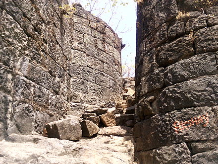
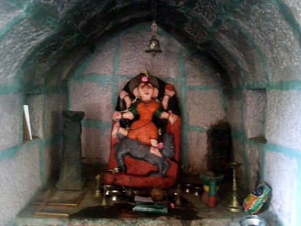
Harishchandragad is a hill fort in the Ahmednagar district of India. Its history is linked with that of Malshej Ghat, kothale village and it has played a major role in guarding and controlling the surrounding region.

Sindhudurg is an administrative district in the state of Maharashtra in India, which was carved out of the erstwhile Ratnagiri District. The district headquarters are located at Oros. The district occupies an area of 5207 km² and has a population of 849,651 of which 12.59% were urban.
Malvanpronunciation (help·info) is a town and taluka in Sindhudurg District, the southernmost district of Maharashtra State, India, well known for the historically important Sindhudurg Fort. Malvan taluka consists of villages such as Angane Wadi, Achra, Khalchi Devli, Jamdul, Juva, Pankhol, Talasheel and Sarjekot. The main occupation here is fishing with the staple diet of the local people fish curry and rice. The town produces Alphonso mangoes and is also known for sweets such as Malvani Khaja made from gram-besan flour and coated jaggery as well as Malvani Ladoos. Other sweets that attract tourists are Konkani meva, Aambawadi, Fanaspoli, Dryfriuts, Kajuwadi, Naralachya Wadya, Malvani Masale. Malvan. Dashavtar, a drama-play based on mythological stories, is an important cultural element of the area. Several apocryphal and some more credible stories related to the name Malvan exist. Salt producers use term Mahalavan to describe a region rich in salt, a compound word from "Maha" meaning great, and "lavan" meaning plantation. Another possibility is a phonetic derivative of the compound of "Mad" and "Ban", Malvani for coconut trees and garden respectively, relating to the large number of coconut trees in the region.malvani language is local language

Mahadpronunciation (help·info) is a city in Raigad district situated in the North Konkan region of Maharashtra state, India. It is located 108.5 km (67.4 mi) from District's Headquarter Alibag, and 167 km (104 mi) from Mumbai, the state capital of Maharashtra and economic capital of India, towards western coast. The city is well-known historically due to its Raigad fort, the capital of Maratha Empire in Shivaji Maharaj's era and revolutionary Mahad Satyagraha launched by Dr. Babasaheb Ambedkar at Chavdar Tale in the wake of Modern India.

Chiplunpronunciation (help·info) is a city and a tehsil in Ratnagiri district in the state of Maharashtra, India. It is the headquarter of Chiplun taluka and located on the Mumbai–Goa highway (NH-66) in western India. The city is about 320 km south of Mumbai in the Konkan region of Maharashtra. It is a fast developing city in Konkan with a strong cultural background. The name Chiplun means "The abode of Lord Parshuram."
Shrivardhan/Shriwardhan is a taluka, city and municipal council in the Raigad district of the Indian state of Maharashtra. It has developed into a seaside resort, along with the nearby town of Harihareshwar, which also has a Shiva temple. Located on a peninsula, the town itself boasts many beaches, in addition to proximity to numerous other beach destinations such as Diveagar Beach and Kondivali Beach. People from across Maharashtra come to Shrivardhan and the nearby beaches all year round.

Devgad is a taluka in Sindhudurg district of MaharashtraIndia consisting of 98 villages. It is located on the Arabian Sea in the coastal Konkan region of Maharashtra, south of Mumbai. Devgad is known globally for its exports of locally grown Alphonso mangoes.
Bhiwandi is a city in the Thane district of Maharashtra state in Konkan division, located 20 km to the north-east of Mumbai and 15 km to the north-east of Thane city. The exact location of Bhiwandi is 19.296664°N 73.063121°E.
Mandangad is the headquarters of Mandangad taluka the northmost taluka in Ratnagiri district of Maharashtra, India.

Shree Kshetra Kanakeshwar( श्री क्षेत्र कनकेश्वर ), on the Konkan coast near Alibag, is a popular place, famous for its cool climate and the old temple of Shiva. The temple is situated on a small hill near the village of Mapgaon and village Zirad which is almost 12 km and 15 km from Alibag respectively. The hill is almost 1200 feet high and one has to climb 700 - 750 steps to reach the temple.

Mangaon is a small town in the Konkan region of Maharashtra, India. It is located in the Raigad district, 80 kilometres from Alibaug headquarters, and 119 kilometres from the state capital of Mumbai, towards the Panjim side.
Goregaon is a small census town in the Mangaon taluka of Raigad district in Maharashtra state. For many years, Goregaon has served as a cultural and educational center for surrounding areas in the region. Situated near the Kal River, a tributary of the Savitri River. Goregaon enjoys an abundance of water and natural features.

Anjarle is a village in the Dapoli taluka of Ratnagiri district in the Maharashtra state of India. It is a small port located near the mouth of Jog river, about 4 miles south of Aade and 2 miles north of Suvarnadurga. The nearest railway station is Khed, 110 miles to the south-east.

Kothaligad(Marathi: कोथळीगड/पेठ चा किल्ला) is a small Fort (3100 ft) is situated to the east of Karjat near Karjat-Murbad Road in the Indian state of Maharashtra. It is one of the famous treks in the Karjat area, because of its small height and easy climbing. It is also known as the Fort of Peth because of its vicinity to Peth village at its base.

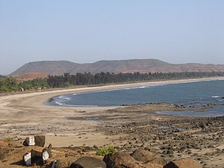
Savitri River is one of the 5 rivers which originate from Mahabaleshwar in Maharashtra state in India.It originates at Savitri point near Mahabaleshwar and flows through the bankot village and directly goes to Arabian sea Raigad district and eventually meets Arabian Sea at Harehareshwar. It passes through rocky and hilly terrain of western ghats till Poladpur and further through the towns of Mahad, Mangaon and Shrivardhan Tehsil (taluka). There are a number of Shiva temples along the banks of river Savitri. Many other small rivers get merged into it at Kapade, Poladpur and Birwadi. Its major tributary is the Kal River which enters from the right (north) near Dasgaon.
Ambav is a small village situated in Sangameshwar Taluka of Ratnagiri District in the state of Maharashtra, India. Ambav is located 6.2 km from Devrukh, 27 km from its Taluka main town of Sangameshwar, 40 km from Ratnagiri, 280 km from Pune and 312 km from Mumbai
Redi is a village in the district of Sindhudurg in Maharashtra. Originally known as Rewati, Redi is located close to the shores of the Arabian Sea. Cashew and coconut trees grow in the region.
Kurdugad Fort is a fort located 143km from Mumbai and 113km from Pune in Raigad district, of Maharashtra. This fort was an important fort in Kolhapur district as a watch over for the trade route from Pune to coastal ports. The fort is surrounded by thick forest and hill slopes.