Related Research Articles

Panhala is a city and a Hill station Municipal Council 18 km northwest of Kolhapur, in Kolhapur district in the Indian state of Maharashtra. Panhala is the smallest city in Maharashtra and being a Municipal Council the city is developing rapidly. The city sprawls in the Panhala fort commands a panoramic view of the valley below. The main historical attraction here is the Panhala fort. There are many places of interest, each with its share of haunting anecdotes.
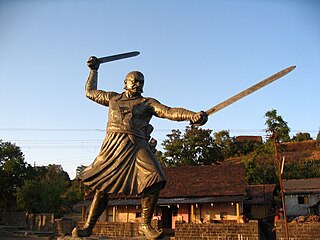
Baji Prabhu Deshpande was a commander of Maratha king Shivaji, the founder of the Maratha empire. The legend of Baji Prabhu is linked with an important rear guard battle enabling Chhatrapati Shivaji's escape from Panhala fort; he was the hero who sacrificed his life for his king.
Miraj is a city in Sangli District, southern Maharashtra, India, that was founded in the early 10th century. It was an important Jagir of the Adil Shahi Court of Bijapur

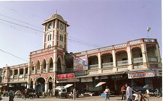
Bhavani Mandap is a historical building situated in the walled city center of Kolhapur in southern Maharashtra, India. It is located near the famous and mammoth Mahalaxmi Temple on the west.

Kodoli is a census town in Kolhapur district in the Indian state of Maharashtra. It is situated between the foothills of Panhala fort (Ranges) and Warana River. Kodoli is well developed town as per all point of view. Kodoli is home to many and variety of industries. This is one of the unique towns in the Maharashtra where you can get glimpse of modernity and heritage at one place e.g. town still inherits open air theaters. Kodoli is the biggest city in Panhala tehsil.

Battle of Pävankhind was a rearguard last stand that took place on 13 July 1660 at a mountain pass in the vicinity of fort Vishalgad, near the city of Kolhapur, Maharashtra, India between the Maratha Warrior Baji Prabhu Deshpande and Siddi Masud of Adilshah Sultanate. The engagement ended with the destruction of the Maratha forces, and a tactical victory for the Bijapur Sultanate, but failing to achieve a strategic victory.
Shahuwadi is a tehsil in the Karvir subdivision of the Kolhapur district in the Indian state of Maharashtra.

Vishalgad was a jagir during the Maratha Empire and then later part of the Deccan States Agency of the British Raj. It was governed by Deshastha Brahmins, who were feudatories of Kolhapur State.
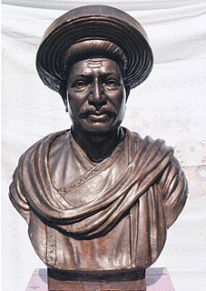
Ramchandra Neelkanth Bawadekar (1650–1716), also known as Ramchandra Pant Amatya, served on the Council of 8 as the Finance Minister (Amatya) to Emperor (Chhatrapati) Shivaji, dating from 1674 to 1680. He then served as the Imperial Regent to four later emperors, namely Sambhaji, Rajaram, Shivaji II and Sambhaji II. He authored the Adnyapatra, a famous code of civil and military administration, and is renowned as one of the greatest civil administrators, diplomats and military strategists of the Maratha Empire.
Kamalgad, also called Bhelanja or Kattalgad is a square hill fort in Wai Taluka in [[Maharashtra]India.

Panhala fort, is located in Panhala, 20 kilometres northwest of Kolhapur in Maharashtra, India. It is strategically located looking over a pass in the Sahyadri mountain range which was a major trade route from Bijapur in the interior of Maharashtra to the coastal areas. Due to its strategic location, it was the centre of several skirmishes in the Deccan involving the Marathas, the Mughals and the British East India Company, the most notable being the Battle of Pavan Khind. Here, the queen regent of Kolhapur, Tarabai, spent her formative years. Several parts of the fort and the structures within are still intact. It is also called as the 'Fort of Snakes' as it is zigzagged in shape

The Munger Fort, located at Munger, in the state of Bihar, India, is built on a rocky hillock on the south bank of the Ganges River. Its history is not completely dated but it is believed that it was built during the early rule of Slave dynasty of India. The Munger town where the fort is situated was under the control of Muhammad bin Tughluq of Delhi. The fort has two prominent hills called the Karnachaura or Karanchaura, and the other a built up rectangular mound deduced to be the location of a citadel of the fort with historical links. The Fort had a succession of Muslim rulers (Khaljis, Tughlaqs, Lodis, Nawabs of Bengal, followed by Mughal rulers, till it was finally acceded to the British by Mir Quasim, after unseating his father-in-aw Mīr Jafar on the grounds of old age, for a monetary reward negotiated by Vansittart. This deal involved payment by the East India Company's merchants of an ad valorem duty of 9 percent, against an Indian merchant’s duty of 40%. The fort became a place of considerable importance to the British in Bengal till 1947.
Samangad is a hill fort in Kolhapur District, Maharashtra. It is 2,600 feet (790 m) above sea level. The fort is situated on the oval-shaped top of the hill. The eight-foot-high wall of the fort which encircled the hill top is still intact. Earlier several cisterns cut out of the rock ensured a plentiful supply of water to the fort but by 1957 most of them were in ruins.

Kolhapur State or Kolhapur Kingdom (1710–1949) was a Maratha princely State of India, under the Deccan Division of the Bombay Presidency, and later the Deccan States Agency. It was considered the most important of the Maratha principalities with the others being Baroda State, Gwalior State and Indore State. Its rulers, of the Bhonsle dynasty, were entitled to a 19-gun salute – thus Kolhapur was also known as a 19-gun state. The state flag was a swallow-tailed saffron pennant.
Mahimangad Fort, in Maan lies within the village limits of Mahimangad village about five and a half miles west of Dahivadi.
Pandavgad Fort), 4177 feet above sea level, lies four miles north-west of Wai. The fort is conspicuous over a low spur branching east from its southern angle. From a distance it appears a square fortification with natural escarpment of cut black stone. The fort can be reached by a footpath diverting to the north from Bhoganv, a village 3 miles west of Wai on Wai -Velang State Transport route. In Bhoganv village, there is a small memorial of Vaman Pandit, the celebrated Sanskrit poet of the 15th century. The approach to the fort is very difficult and at places the path is barely a foot in width with the hill slopes on one side and deep valleys on the other. Hill though not covered with thick forest has a considerable foliage of bushy shrubs. A path from Bhogaon leads to small break in the above-mentioned spur and from this break it continues by a shoulder of the hill, on which are few huts belonging to Kolis formerly connected with the fort and charged with attendance on the temple. The ascend from the Koli hills is steepish and for the last two hundred yards had steps cut in stone. At the northern end the path reaches the entrance gate which now consists of two broken pillars of enormous size. It had a single archway with apparently no door. The fort is about six acres in extent and nearly a square. Its defences consist of a scarp generally from forty to sixty feet high, more than usually precipitous and in many places actually overhanging and surmounted by a wall with masonry ramparts. The original materials of enormous blocks of dry stone have nearly all disappeared and except the northern end where the gateway and wall are of the huge masonry of the old forts what remains is very light work. Of the 18 ponds which supplied the garrison with water, only three possess water. On the top a large pond on the eastern part is silted up. To the north of the main gate, some 150 feet down the shoulder of the hill is a group of small ill maintained rock cut water cisterns. All the buildings on the fort excepting that of the temple of Pandjaidevi are in a state of complete ruin. The temple is built in local stone masonry and is not in any way imposing. A hall in front of the shrine of devi measures about 30'X20' and has a flat roof supported on four pillars. Number of ancient buildings on the fort have been reduced to a mere heap of bricks. In the centre, remains of the main building are hidden by a thick growth of bushy shrubs. The fort commands an excellent view of the surrounding area. To the east one gets a bird's eye view of Wai, and Mandhardev stands conspicuously about 4 miles to the north-west. To the west Kenjalgad marks a prominent object at a distance of about 5 miles.

Kenjalgad Fort in Wai, Maharashtra is a fort eleven miles (18 km) north-west of Wai. It is located on the Mandhardev spur of the Mahadev hill range. The fort is visible from quite a long distance as a stone scarp 30–40 feet high rising as a cap on the irregular hill. The fort is rhomboid in shape with 388m long axis and 175m short axis.
Varugad Fort , in Man lies, as the crow flies, about twelve miles north-west of Dahivadi, within the limits of Panvan village. The best way to it is to camp at Pingli Budrukh four miles south-west of Dahivadi and to travel thence by the Tasganv-Mograla road for about ten miles to Jadhavvadi, a hamlet of Bijvadi village lying almost a quarter of a mile east and within sight of the road; from here a well marked track due west goes to the village of Tondle, and from Tondle a path leads direct to the fort over rough ground broken but perfectly passable by a pony, and skirting the northern base of the long plateau of Panvan. The direction of the path is generally a little north of west and it crosses innumerable small ravines and water-courses which lead through rough hill tracts to the edge of the plateau of which the Man taluka chiefly consists. These streams pour down the bare sides of the main hill range, here some 1,000 to 1,500 feet high, on to the plain of Girvi adjoining the Phaltan taluka. The country all the way from Pingli is terribly bare and rocky. Here the stony hills and ravines are interrupted by fairly level plateaus with tolerable soil and good sites for cultivation and grazing. A few small deer and chinkharawill probably be seen, while cattle are everywhere browsing in considerable numbers. Three hamlets, one of them known as Ghodavadi, are reached, and some well-to-do cultivators will probably meet the visitor and turn out to be Gadkaris or descendants of the ancient hereditary fort garrison. The hamlet is situated on a projection between the two ravines, and has been built on a hill of a truncated conical shape. The hill rises about 250 feet above the level of the plateau, which itself constitutes the summit of the Mahadev range at this point. The cone with the walls on it is seen from a great distance and appears very small indeed. But on near approach it is seen to be but the inner citadel of a place of considerable size and strength for the times in which it was built. On the south-west the outer wall or enceinte is entered by a rude gateway of a single pointed arch about eight feet high and five feet broad. As usual there is a curtain of solid masonry inside. The gate lies about 150 yards east of the edge of the plateau, which there terminates in an almost unbroken vertical precipice of several hundred feet in height and receding in a north-easterly direction. No wall was built along about three hundred yards of this part which is absolutely unscalable, but for the rest of the way the walling is continued along the edge of the cliff in a north-east direction for about another three hundred yards. Here it turns still following the cliff to the south-east for another seven hundred yards, and then gradually rounds to the westward covering four hundred and fifty yards more till it meets the gateway. But for the break of the inaccessible precipice this outer wall would form a nearly equilateral triangle with the corners rounded off, the side being of some six hundred and fifty yards. Facing nearly north, about fifty yards from the north-east angle, is a gateway with a couple of curtains in solid masonry. This entrance is cut in the sides of the cliff about twenty feet below the top which is reached by some dozen steps. It consisted as usual of a pointed arch, the top fallen in, about ten feet high by five broad. It leads out to the path down to Girvi, a village in the plains below and it probably formed the communication with Phaltan. This road winds down the face of the range for some five hundred feet till it hits the shoulder of a spur which it then follows to the base. The walling on the south side, from the edge of the cliff to some hundred yards east of the southern gate, is not more than a couple of feet in thickness and consists of all-fitting stones unmortared. The rest is massive and well mortared and still fairly preserved. The average height is from seven to ten feet. In the south-east angle is a rude temple of Bhairavnath and a few houses with the remains of Man y more. On the right side of the southern gate is a well preserved stone pond about thirty yards square with steps leading down to it. Next to and on the north of Bhairavnath's temple is another pond. The way up to the fort proper or upper and lower citadels is from the north side. The path up the hill side, which is steep but with grass and soil left in Man y places, is almost destroyed. About 150 feet up is the outer citadel built on a sort of shoulder of the hill and facing almost due west. It contains two massive bastions of excellent masonry looking north-west and south-west so that guns planted on them could comMan d respectively the north and south gateways. This citadel was connected with the main wall by a cross wall running across the whole breadth of the fort from east to west. Its entrance lies close below that to the upper citadel. A masonry curtain projects so as to hide the arch itself, which is not more than seven feet high by three broad, and has to be entered from due east. On the south side the walls are carried right up to the scarp of the upper citadel and are some ten feet high, so that to take the lower citadel in rear or flank must have been difficult. The upper citadel is above a vertical scarp some thirty feet high. The entrance to it lies some thirty feet above that to the lower citadel, and is cut in the rock about eight feet wide. There is a gateway of a pointed arch with the top fallen in and twenty odd steps leading up to it and ten more cut out of the rock, and winding up past the inside curtain on to the top. The walls of this upper citadel are still in tolerable preservation. They were originally about ten feet high and built of fair masonry. There is a large turret on the south-west corner, evidently meant to comMan d the southern gate. About ten yards to the east of this turret is a new looking building which was the headquarters or sadar. Immediately east of this and below it is a great pit about thirty feet square and equally deep roughly cut in the rock and said by the people to be a dungeon. Next to it on the south is a small pond evenly cut and lined with mortar used for storing water. There are some remains of sepoys' houses, and, near the turret, a small stone wheel said to belong to a gun. The outer walls east of the gates have bastions at every turn of the cliffs, and the masonry here is particularly strong and well preserved. It would appear that attacks were dreaded chiefly from the plain below. The assailants could either come up the spur towards the north entrance or they might attempt the spurs on the other side of the eastern ravine and attack the southern gateway. Hence apparently the reason for strengthening the walls of the enceinte on this side. After passing the southern gateway the assailants would be comMan ded from the lower citadel. They Would then be encountered by the cross wall. If that obstacle was overcome the besieged would run round the east side and into the two citadels. The appearance from the fort of the plain in the north is most formidable. The Panvan plateau completely comMan ds and indeed almost overhangs it. The fort is believed to have been built by Shivaji to resist the Moghals whose attacks he must have dreaded from the plain below. The Karkhanis or Superintendent of the fort was a Prabhu. The fort garrison consisted of 200 Ramoshis, Mahars, and other hereditary Gadkaris besides sepoys. It was surrendered in 1818 to Vitthal Pant Phadnis of the Raja of Satara left in charge of the town. He detached 200 men to take possession, being part of a force then raised to protect the town from the enterprizes of Bajirav's garrisons then in the neighbourhood. [Elphinstone in Pendhari and Maratha War Papers, 245.]

Dategad Fort is a small fort located 75 kilometres (47 mi) South of Satara, in the Maharashtra state of India. This fort can be visited in a day from Satara. The nearest town is Patan. The base village is Tolewadi from where an easy trek of 45 minutes leads to the entrance of the fort.
Manohargad-Mansantoshgad Fort are two adjacent forts located on the same hill but separated by a saddle. This fort is situated at Shivapur, Tal - Kudal. The forts are 33 km from Sawantwadi and the same distance from Kudal Sindhudurg district of Maharashtra. The forts are situated on the hill north of the base village Shivapur.The fort is located in the proximity of the Amboli hill station.
References
- ↑ "Friends of Forts". Archived from the original on April 5, 2009. Retrieved 2009-03-16.
- 1 2 Gazetteer of the Bombay Presidency. Govt Central Press. 1886. pp. 316–317. Retrieved 2009-03-17.
pavangad.