Salher is a place located near Waghamba in Satana tehsil in Nashik district of Maharashtra, India. It is the site of the highest fort in the Sahyadri mountains and the second highest peak at 1,567 metres (5,141 ft) after Kalsubai in Maharashtra and 32nd highest peak in Western Ghats. This was one of the celebrated forts of the Maratha Empire. The money acquired after raiding Surat was brought to this fort first on its way to the Maratha capital forts.
Mulher is a village in the Nashik district of Maharashtra, India.
Lohagad is one of the many hill forts of Maharashtra state in India. Situated close to the hill station Lonavala and 52 km (32 mi) northwest of Pune, Lohagad rises to an elevation of 1,033 m (3,389 ft) above sea level. The fort is connected to the neighboring Visapur fort by a small range. The fort was under the Maratha empire for the majority of the time, with a short period of 5 years under the Mughal empire.
Kamalgad, also called Bhelanja or Kattalgad is a square hill fort in Wai Taluka in Maharashtra, India.

Baglan is a taluka (tehsil) in Nashik District in the Indian state of Maharashtra. Sometimes Baglan Taluka is unofficially referred to as Satana, because of that city's dominance within the taluka.

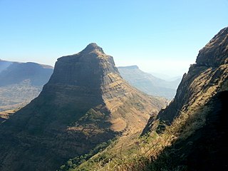
Ankai Fort is a historic site found in the Satmala Range hills in western India. It is located in Yeola Taluka of Nashik district in the state of Maharashtra. The fort was built by Yadava of Devgiri. Geographically, it is near Manmad. The Ankai fort and Tankai fort are two different forts on adjacent hills. A common fortification is constructed to secure both. The Ankai fort is located on a hill with perpendicular scarps on all the sides, except for a narrow nose on the eastern side.

Ghangad is a fort situated near 30km from Lonavla-Khandala and 100 km from Pune in Maharashtra state, India.This fort is an important fort in the Pune district. The fort restoration is done by the Shivaji Trail group with the help of local villagers. The fort is at least 300 years old. Restoration work took place in 2011-12.
Nhavigad is also called as Nhavagad or Ratangad. It is located in the Baglan area of Nashik district. There are two main hill ranges in Baglan area the Selbari range and Dholbari range. These two ranges run parallel to each other in east-west direction. Nhavigad is located in Selbari mountain range. All these forts were maintained to keep watch on the Burhanpur-Surat ancient commercial road. The road passes between the two hill ranges. Nhavigad is a small fort, but very difficult to climb.

Mora fort is located in the Baglan area of Nashik district. There are two main hill ranges in Baglan area, the Selbari range is south of the Dolbari hill range. These two ranges run parallel to each other in east-west direction. Moragad is located on Selbari hill range. All these forts were maintained to keep watch on the Burhanpur-Surat ancient commercial road. The road passes between the two hill ranges. Mora fort is a small fort, east of Mulher fort.
Salota fort is a hill fort in Maharashtra, India. It is located in the Baglan region of Nashik. It lies close to the Salher fort.

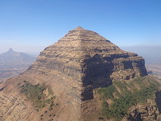
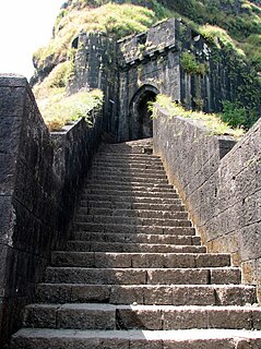
Harihar fort / Harshagad is a fort located 40 km from Nashik City, 48 km from Igatpuri, 40 km from Ghoti in Nashik district, of Maharashtra, India. It is an important fort in Nashik district, and was constructed to look upon the trade route through Gonda Ghat. It receives many visitors because of its peculiar rock-cut steps.
Indrai Fort / Indragiri Fort is a fort located 75 km from Nashik, in Nashik district, of Maharashtra. This fort though is an important fort in Nashik district but, it is less visited by the trekkers. In Chandwad taluka, there are 4 forts in a line on the Satmal hill range, the Chandwad fort, Indrai fort, Rajdher fort, and Koldher fort. This fort is easy to climb but requires 3 hours to reach the fort.

Peb Fort / Vikatgad Fortis a fort located 19km from Karjat, in Raigad district, of Maharashtra. This fort is in continuation with the Malang gad, Tauli Hill and Chanderi fort of the Matheran Hill Range. Vikatgad is a favourite destination for one-day trekkers. The trek path to Vikatgad is along deep ravines and cliffs. Its closeness to Matheran and Neral attracts many trekkers on weekends. The forest department and local villagers are doing plantation and some restoration works on the fort.
Rajdeher Fort (Marathi: राजधेर किल्ला) is a fort located 10 km (6.2 mi) from chandwad, Nashik district, of Maharashtra. This fort is an important fort in Nashik district.

Asheri Fort / Asheri is a fort located 102 km from Mumbai and 88 km from Thane. It is in Palghar district, of Maharashtra. This fort is an important fort in Palghar district. The fort is located on the hills near Mendhavan Khind on Mumbai-Ahmedabad highway. The base village Khodkona is a very small tribal village. The Fort restoration is done by the local villagers.
Ahivant Fort is a fort located 55km from Nashik, in Nashik district, of Maharashtra. This fort is an important fort in Nashik district. The three forts Achala, Ahivant, and Mohandar are very close by. The other two forts were constructed to guard the Ahivant fort.
Achala Fort is a westernmost fort in the Satmala hill range. It is located 55km from Nashik, in Nashik district, of Maharashtra. This fort is adjoining the Ahivant Fort. The three forts Achala, Ahivant, and Mohandar are very close by. The Achala and Mohandar forts were constructed to guard the Ahivant fort. Captain Briggs has described it as a large hill, whose ascent is very easy till it reaches the top where it is very steep.

Pisola Fort is a fort located 125 km (78 mi) from Nashik, in the Nashik district of Maharashtra, India. This fort lies exactly on the borders of Dhule & Nashik District. One side is in Sakri Taluka & another is in Satana Taluka. Though this fort is an important fort in Nashik district, it is less visited by trekkers. In Satana taluka, there are four forts in a line on the Galna hill range, the Pisol fort, Dermal fort, Kankrala fort and Galna fort. This fort is easy to climb but requires one hour to reach the fort.
Chauler Fort is a small fort located 100 kilometres (62 mi) north of Nashik, in the Indian state of Maharashtra. This fort can be visited in a day from Nashik. The nearest town is Satana.
Dermal Fort is a fort located 125 mi (201 km) from Nashik, in the Nashik district of Maharashtra, India. Though this fort is an important fort in Nashik district, it is less visited by trekkers. In Satana taluka, there are four forts in a line on the Galna hill range, the Pisola fort, Dermal fort, Kankrala fort and Galna fort. This fort is easy to climb but requires two hour to reach the fort. There are very few remains of old buildings on the fort.


