Nashik district, also known as Nasik district, is a district in Maharashtra, India. The city of Nashik is the administrative headquarters of the district. Nashik is well known for the production of wine. Nashik is also known as Mini Maharashtra, because the climate and soil conditions of Surgana, Peth, Igatpuri resembles with Konkan. Niphad, Sinnar, Dindori, Baglan blocks are like Western Maharashtra and Yeola, Nandgaon, Chandwad blocks are like Vidarbha Region. Nashik is the biggest city in the district while Malegaon is the second biggest city. Manmad, Igatpuri, and Sinnar are some of the big cities situated in the Nashik District. Manmad is one of the biggest railway junctions in India while the city of Malegaon is famous for its powerloom.
Salher is a place located near Salher Village in Satana tehsil in Nashik district of Maharashtra, India.The old name of Salher was Gavalgarh. It is the site of the highest fort in the Sahyadri mountains and the second highest peak at 1,567 metres (5,141 ft) after Kalsubai in Maharashtra and 32nd highest peak in Western Ghats. This was a fort of the Maratha Empire. The money acquired after raiding Surat was brought to this fort first on its way to the Maratha capital forts.
Mulher is a village in the Nashik district of Maharashtra, India.

Baglan is a taluka (tehsil) in Nashik District in the Indian state of Maharashtra. Sometimes Baglan Taluka is unofficially referred to as Satana, because of that city's dominance within the taluka.
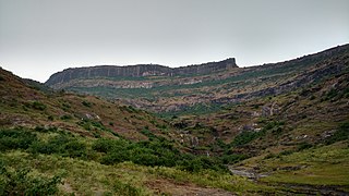
Selbari is a mountain range located in Nashik District in Maharashtra, India. Spanning east-west the hills form the northernmost extent of the Sahyadris and serve as a natural boundary between Nashik District and Dhule district. The range is gifted with a number of peaks including the only two-pinnacled peak of Mangi-Tungi rising to a considerable height of up to 1,331 meters.

Ankai Fort is a historic site found in the Satmala Range hills in western India. It is located in Yeola Taluka of Nashik district in the state of Maharashtra. The fort was built by Yadava of Devgiri. Geographically, it is near Manmad. The Ankai fort and Tankai fort are two different forts on adjacent hills. A common fortification is constructed to secure both. The Ankai fort is located on a hill with perpendicular scarps on all the sides, except for a narrow nose on the eastern side.
Nhavigad is also called as Nhavagad or Ratangad. It is located in the Baglan area of Nashik district. There are two main hill ranges in Baglan area the Selbari range and Dholbari range. These two ranges run parallel to each other in east-west direction. Nhavigad is located in Selbari mountain range. All these forts were maintained to keep watch on the Burhanpur-Surat ancient commercial road. The road passes between the two hill ranges. Nhavigad is a small fort, but very difficult to climb.
Salota fort is a hill fort in Maharashtra, India. It is located in the Baglan region of Nashik. It lies close to the Salher fort.

Kulang fort is located in the Igatpuri area of Nashik district, on the western side of the Kalsubai hill range. This fort is adjacent to the Madangad and Alang forts, all of which were constructed to protect the Nashik-Kalyan ancient commercial road.

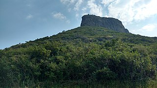
"Bhaskargad Fort, alternatively known as Basgad Fort, is a hill fort situated within the Nashik district of Maharashtra, India. Part of the Trimbak hill range, it lies in proximity to Harihar Fort. Located approximately 48 kilometers away from Igatpuri, Bhaskargad Fort is recognized as a favored site for activities such as trekking and hiking."

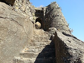
Harihar fort / Harshagad is a fort located 40 km from Nashik City, 48 km from Igatpuri, 40 km from Ghoti in Nashik district, of Maharashtra, India. It is an important fort in Nashik district, and was constructed to look upon the trade route through Gonda Ghat. It receives many visitors because of its peculiar rock-cut steps.
Indrai Fort / Indragiri Fort is a fort located 75 km from Nashik, in Nashik district, of Maharashtra. This fort though is an important fort in Nashik district but, it is less visited by the trekkers. In Chandwad taluka, there are 4 forts in a line on the Satmal hill range, the Chandwad fort, Indrai fort, Rajdher fort, and Koldher fort. This fort is easy to climb but requires 3 hours to reach the fort.

Vikatgad / Peb Fort is a fort located 19 km (12 mi) from Karjat, in Raigad district, of Maharashtra. This fort is in continuation with the Malang gad, Tauli Hill and Chanderi fort of the Matheran Hill Range. Vikatgad is a favourite destination for one-day trekkers. The trek path to Vikatgad is along deep ravines and cliffs. Its closeness to Matheran and Neral attracts many trekkers on weekends. The forest department and local villagers are doing plantation and some restoration works on the fort. The altitude of Vikatgad, also known as Peb fort is 640 meters above sea level.
Rajdeher Fort (Marathi: राजधेर किल्ला) is a fort located 10 km (6.2 mi) from chandwad, Nashik district, of Maharashtra. This fort is an important fort in Nashik district.
Ahivant Fort is a fort located 55km from Nashik, in Nashik district, of Maharashtra. This fort is an important fort in Nashik district. The three forts Achala, Ahivant, and Mohandar are very close by. The other two forts were constructed to guard the Ahivant fort.

Pisola Fort is a fort located 125 km (78 mi) from Nashik, in the Nashik district of Maharashtra, India. This fort lies exactly on the borders of Dhule & Nashik District. One side is in Sakri Taluka & another is in Satana Taluka. Though this fort is an important fort in Nashik district, it is less visited by trekkers. In Satana taluka, there are four forts in a line on the Galna hill range, the Pisol fort, Dermal fort, Kankrala fort and Galna fort. This fort is easy to climb but requires one hour to reach the fort.

Hargad Fort is located in the Baglan area of Nashik district. There are two main hill ranges in Baglan area, the Selbari range is south of the Dolbari hill range. These two ranges run parallel to each other in east-west direction. Hargad is located on Selbari hill range. All these forts were maintained to keep watch on the Burhanpur-Surat ancient commercial road. The road passes between the two hill ranges. Hargad fort is a small fort, close to Mulher fort. These are key forts situated between fertile lands of Khandesh and port city of Surat.
Bitangad Fort is a fort in Nashik district in the Igatpuri taluka in Maharashtra state of India.
Chauler Fort is a small fort located 100 kilometres (62 mi) north of Nashik, in the Indian state of Maharashtra. This fort can be visited in a day from Nashik. The nearest town is Satana.
Dermal Fort is a fort located 125 mi (201 km) from Nashik, in the Nashik district of Maharashtra, India. Though this fort is an important fort in Nashik district, it is less visited by trekkers. In Satana taluka, there are four forts in a line on the Galna hill range, the Pisola fort, Dermal fort, Kankrala fort and Galna fort. This fort is easy to climb but requires two hour to reach the fort. There are very few remains of old buildings on the fort.