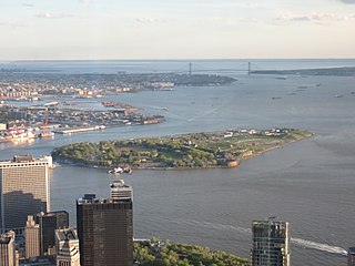
Governors Island is a 172-acre (70 ha) island in New York Harbor, within the New York City borough of Manhattan. It is located approximately 800 yards (732 m) south of Manhattan Island, and is separated from Brooklyn to the east by the 400-yard-wide (370 m) Buttermilk Channel. The National Park Service administers a small portion of the north end of the island as the Governors Island National Monument, including two former military fortifications named Fort Jay and Castle Williams. The Trust for Governors Island operates the remaining 150 acres (61 ha), including 52 historic buildings, as a public park. About 103 acres (42 ha) of the land area is fill, added in the early 1900s to the south of the original island.

Veracruz, also known as Heroica Veracruz, is a major port city and municipal seat for the surrounding municipality of Veracruz on the Gulf of Mexico in the Mexican state of Veracruz. The city is located along the coast in the central part of the state, 90 km (56 mi) southeast of the state capital Xalapa along Federal Highway 140.

Vis is a town on the eponymous island in the Adriatic Sea in southern Croatia. Its population was 1,934 as of 2011. The town is the seat of the eponymous Vis municipality, one of the island's two municipalities. Both belong administratively to Split-Dalmatia County.

Cramond Village is a village and suburb in the north-west of Edinburgh, Scotland, at the mouth of the River Almond where it enters the Firth of Forth.

Fort San Pedro is a military defense structure in Cebu, Philippines, built by the Spanish under the command of Miguel López de Legazpi, first governor of the Captaincy General of the Philippines. It is located in the area now called Plaza Independencia, in the pier area of the city. The original fort was made of wood and built after the arrival of Legazpi and his expedition. In the early 17th century a stone fort was built to repel Muslim raiders. Today's structure dates from 1738 and is the oldest triangular bastion fort in the country. It served as the nucleus of the first Spanish settlement in the Philippines. During the Philippine Revolution at the end of the 19th century, it was attacked and taken by Filipino revolutionaries, who used it as a stronghold.
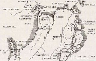
The Sion Hillock Fort is a fort in Mumbai (Bombay), India. It was built under the regime of the English East India Company, between 1669 and 1677, atop a conical hillock when Gerard Aungier was the Governor of Bombay. It was notified in 1925 as a Grade I Heritage structure. When it was built, the fort marked the boundary between British-held Parel island and the Portuguese held Salsette Island that lay to the north across the creek.

Sindhudurg Fort is a historical fort that occupies an island in the Arabian Sea, just off the coast of Maharashtra in Western India. The fort was built by Shivaji Maharaj.The fortress lies on the shore of Malvan town of Sindhudurg District in the Konkan region of Maharashtra, 450 kilometres (280 mi) south of Mumbai. It is a protected monument.

Arad Fort is a 15th-century fort in Arad, Bahrain. Formerly guarding a separate island of its own, the fort and its surroundings have since been joined to Muharraq Island.

Arnala Fort is built on a small island off the port town of Arnala, located around 13 km north of Bassein, Maharashtra, India. Being an island fort, it is also called Jaldurg or Janjire-Arnala. The Portuguese, who built the present fort, called the island Ilha das Vacas.

Raigad is a hill fort situated in Mahad, Raigad district of Maharashtra, India. It is one of the strongest fortresses on the Deccan Plateau. It was previously known as Rairee or Rairy fort.

Pons Aelius, or Newcastle Roman Fort, was an auxiliary castra and small Roman settlement on Hadrian's Wall in the Roman province of Britannia Inferior, situated on the north bank of the River Tyne close to the centre of present-day Newcastle upon Tyne, and occupied between the 2nd and 4th centuries AD.
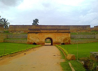
Devanahalli Fort is located 35 kilometers (22 mi) north of Bangalore city, at Devanahalli in the State of Karnataka, India. Chieftain Malla Byre Gowda of Avathi, a Vijayanagara empire vassal, built a mud fort in c. 1501 at Devanadoddi. In the late 18th century, Hyder Ali re-constructed the fort in stone resulting in the current structure.

Panhala fort, is located in Panhala, 20 kilometres northwest of Kolhapur in Maharashtra, India. It is strategically located looking over a pass in the Sahyadri mountain range which was a major trade route from Bijapur in the interior of Maharashtra to the coastal areas. Due to its strategic location, it was the centre of several skirmishes in the Deccan involving the Marathas, the Mughals and the British East India Company, the most notable being the Battle of Pavan Khind. Here, the queen regent of Kolhapur, Tarabai Ranisaheb, spent her formative years. Several parts of the fort and the structures within are still intact. It is also called as the 'Fort of Snakes' as it is zigzagged in shape.

Korlai Fort is a colonial fort in the Raigad district of Maharashtra, India. Formerly a part of the Chaul in Portuguese India, the structure is a specimen of Portuguese colonial architecture. It was built as a companion to the fort at Chaul, at this strategic position the Portuguese could use it to defend their province which stretched from Korlai to the Fort Bassein. Vestiges of the Portuguese occupation are manifested in the distinct dialect of the Korlai villages inhabitants which is a Luso-Indian creole called Korlai Portuguese Creole.
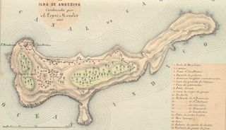
Fort Anjediva, built on the Anjadip Island, off the coast of the Indian state of Karnataka but under the administrative jurisdiction of the Indian state of Goa, was once under Portuguese rule. The island of Anjadip has an area of 1.5 square kilometres (0.58 sq mi).

The Munger Fort, located at Munger, in the state of Bihar, India, is built on a rocky hillock on the south bank of the Ganges River. Its history is not completely dated but it is believed that it was built during the early rule of Slave dynasty of India. The Munger town where the fort is situated was under the control of Muhammad bin Tughluq of Delhi. The fort has two prominent hills called the Karnachaura or Karanchaura, and the other a built up rectangular mound deduced to be the location of a citadel of the fort with historical links. The Fort had a succession of Muslim rulers (Khaljis, Tughlaqs, Lodis, Nawabs of Bengal, followed by Mughal rulers, till it was finally acceded to the British by Mir Quasim, after unseating his father-in-aw Mīr Jafar on the grounds of old age, for a monetary reward negotiated by Vansittart. This deal involved payment by the East India Company's merchants of an ad valorem duty of 9 percent, against an Indian merchant’s duty of 40%. The fort became a place of considerable importance to the British in Bengal till 1947.
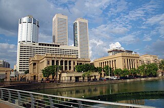
Fort (Colombo) (කොටුව; கோட்டை) is the central business district of Colombo in Sri Lanka. It is the financial district of Colombo and the location of the Colombo Stock Exchange (CSE) and the World Trade Centre of Colombo from which the CSE operates. It is also the location of the Bank of Ceylon headquarters. Along the foreshore of the Fort area is the Galle Face Green Promenade, built in 1859 under the governance of Sir Henry George Ward, the Governor of Ceylon (Sri Lanka) during British colonial era. Fort is also home to the General Post Office, hotels, government departments and offices.

The Gates of Delhi were city gates in Delhi, India, built under dynastic rulers in the period that could be dated from the 8th century to the 20th century. They are the gates in:

The Diu Fortress is a Portuguese-built fortification located on the west coast of India in Diu. The fortress was built as part of Portuguese India's defensive fortifications at the eastern tip of the island of Diu during the 16th century. The fortress, which borders on the town of Diu, was built in 1535 subsequent to a defense alliance forged by Bahadur Shah, the Sultan of Gujarat and the Portuguese when Humayun, the Mughal Emperor attempted to annex this territory. It was strengthened over the years, till 1546. The Portuguese ruled over this territory from 1537 until the Indian invasion of December 1961. Today it is a landmark of Diu and one of the Seven Wonders of Portuguese Origin in the World.
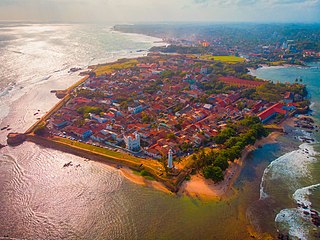
Galle Fort, in the Bay of Galle on the southwest coast of Sri Lanka, was built first in 1588 by the Portuguese, then extensively fortified by the Dutch during the 17th century from 1649 onwards. It is a historical, archaeological and architectural heritage monument, which even after more than 432 years maintains a polished appearance, due to extensive reconstruction work done by Archaeological Department of Sri Lanka.
