
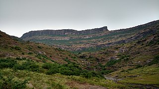
Satmala (pronunciation:[sɐtmaːla]) is a mountain range which runs across Nashik District, Maharashtra. They are an integral part of the Sahyadris range within Nashik. These peaks are visible from a greater part of the district and form prominent landmarks. The highest of them is Dhodap. Dhodap hill is the third highest hill peak in Maharashtra after Kalsubai and Salher and 29th highest peak in the Western Ghats. At the eastern side of this range lies the Chandvad range. There is a range with the same name Satmala in Telangana.
It is a fort located in malegaon taluka Galna was a major fort in the south Khandesh area of Maharashtra, India. This fort was an important fort on the Burhanpur -Surat trade route. This is one of the forts in Maharashtra with the bastion and the entrance in good condition. This fort is located on hills between Malegaon and Dhule.

Bhaskargad Fort, also known as Basgad Fort, is a hill fort located in the Nashik district of Maharashtra, India. It is one of the forts in the Trimbak hill range, and is situated near the Harihar fort. The fort is about 48 kilometers from Igatpuri, and is a popular destination for trekking and hiking.

Harihar fort / Harshagad is a fort located 40 km from Nashik City, 48 km from Igatpuri, 40 km from Ghoti in Nashik district, of Maharashtra, India. It is an important fort in Nashik district, and was constructed to look upon the trade route through Gonda Ghat. It receives many visitors because of its peculiar rock-cut steps.
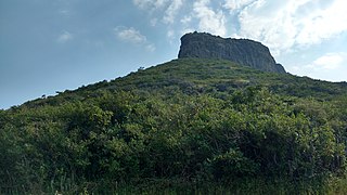
Indrai Fort / Indragiri Fort is a fort located 75 km from Nashik, in Nashik district, of Maharashtra. This fort though is an important fort in Nashik district but, it is less visited by the trekkers. In Chandwad taluka, there are 4 forts in a line on the Satmal hill range, the Chandwad fort, Indrai fort, Rajdher fort, and Koldher fort. This fort is easy to climb but requires 3 hours to reach the fort.
Rajdeher Fort (Marathi: राजधेर किल्ला) is a fort located 10 km (6.2 mi) from chandwad, Nashik district, of Maharashtra. This fort is an important fort in Nashik district.
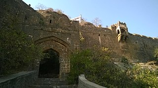
Chandwad Fort is located 3 kilometres (1.9 mi) from Chandwad, Nashik district, of Maharashtra.
Ahivant Fort is a fort located 55km from Nashik, in Nashik district, of Maharashtra. This fort is an important fort in Nashik district. The three forts Achala, Ahivant, and Mohandar are very close by. The other two forts were constructed to guard the Ahivant fort.
Gopalgad Fort / Anjanvel Fort is a fort located 51 km (32 mi) from Chiplun, in Ratnagiri district, of Maharashtra. This fort is an important fort in Ratnagiri district. The Fort is located on a prominent and commanding point for guarding the trade route along the Vashishti River, which runs till Govalkot near Chiplun and the Dabhol port which was a busy route in medieval times. It is a fort located on a hill near the sea.
Hatgad Fort is a fort located 71 km (44 mi)from Nashik, Nashik district, of Maharashtra. The base village is Hatgad on the Nashik-Saputara Road. The nearest town is Saputara, which is 6 km from Hatgad village. It is a historic monument located in Maharashtra, India, south of the hill station of Saputara and near the border with Gujarat. It was built by the Maratha king Shivaji and is located at an elevation of about 3,600 feet. The way to reach the fort is through a trekking route via a narrow rocky path and car also go up to the stairs of fort. A statue of Lord Shivling is placed on the top of the fort.

Pisola Fort is a fort located 125 km (78 mi) from Nashik, in the Nashik district of Maharashtra, India. This fort lies exactly on the borders of Dhule & Nashik District. One side is in Sakri Taluka & another is in Satana Taluka. Though this fort is an important fort in Nashik district, it is less visited by trekkers. In Satana taluka, there are four forts in a line on the Galna hill range, the Pisol fort, Dermal fort, Kankrala fort and Galna fort. This fort is easy to climb but requires one hour to reach the fort.
Trymbakgad Fort/Brahmagiri Fort is a fort located 30 km from Nashik, in Nashik district, of Maharashtra, India. This is an important fort in Nashik district. It is located on a hill adjoining the famous Trimbakeshwar temple.

Hargad Fort is located in the Baglan area of Nashik district. There are two main hill ranges in Baglan area, the Selbari range is south of the Dolbari hill range. These two ranges run parallel to each other in east-west direction. Hargad is located on Selbari hill range. All these forts were maintained to keep watch on the Burhanpur-Surat ancient commercial road. The road passes between the two hill ranges. Hargad fort is a small fort, close to Mulher fort. These are key forts situated between fertile lands of Khandesh and port city of Surat.
Ghargad Fort / Gadgada Fort is a fort located 145 km from Mumbai, in Nashik district, of Maharashtra. This fort is less visited fort in Nashik district. This fort is quite difficult to climb.
Javlya Fort is located 43 km from Nashik, Nashik district, of Maharashtra. Ravlya fort and Javlya fort are twin forts located on a single hill plateau, Ravlya on the west and Javlya on the east side of the hill plateau.
Ravalya Fort is located 43 km from Nashik, Nashik district, of Maharashtra. The Ravlya fort and Javlya fort are twin forts located on a single hill plateau. Ravlya on the west and the Javlya on the east side of the hill plateau.
Chandragad Fort / Dhavalgad Fort is a fort located 182 km from Mumbai, in raigad district, of Maharashtra. This fort was an important fort in raigad district as a watch over for the Varandha Ghattrade routes from Bhor to kokan. The fort is surrounded by forest and hill slopes.
Markandya Fort/Markinda Fort/ Markanda fort is a fort located 52 km (32 mi)from Nashik, Nashik district, of Maharashtra. The base village is Mulane on the Wani-Kalwan Link Road. The nearest town is Wani, which is 5.5 km from Mulane village. This fort is opposite the holy Saptashringi hill..
Koldher Fort is a fort located 11.26 km (7.00 mi) from chandwad, Nashik district, of Maharashtra. This fort is close to the Rajdher fort and lies westwards. It requires about 1-2 hours to reach the fort from Rajdher.

Mohandar Fort / Shidaka fort is a fort located 55 km from Nashik, in Nashik district, of Maharashtra, India. This fort is an important fort in Nashik district. The three forts Achala, Ahivant, and Mohandar are very close by. This fort was constructed to guard the Ahivant fort. This fort can be seen from a long distance due to the presence of needle hole in the cliff below this fort.
