Ankai Fort

Last updated

Ankai Fort
Part of Ajintha Satmal Hill Range
Nashik district, Maharashtra
Ankai Fort14.jpg
Ankai fort from Highway
India Maharashtra location map.svg
Red pog.svg
Ankai Fort
Coordinates 20°11′14″N74°26′51.5″E / 20.18722°N 74.447639°E / 20.18722; 74.447639
TypeHill fort
Height966.22 M (3170 Ft)
Site information
OwnerGovernment of India
Controlled by  Ahmadnagar (1521-1594)
Mughal Empire (1594-1739)
Flag of the Maratha Empire.svg  Maratha (1739-1818)
Flag of the United Kingdom.svg  United Kingdom Flag of India.svg  India (1947-present)
Open to
the public
Yes
ConditionIn ruins
Site history
MaterialsStone

Ankai Fort is a historic site found in the Satmala Range hills in western India. [1] [2] It is located in Yeola Taluka of Nashik district in the state of Maharashtra. The fort was built by Yadava of Devgiri. Geographically, it is near Manmad. The Ankai fort and Tankai fort are two different forts on adjacent hills. A common fortification is constructed to secure both. The Ankai fort is located on a hill with perpendicular scarps on all the sides, except for a narrow nose on the eastern side.

Contents

History

The Jain caves located at the foothills of the fort, spanning two levels. On the lower level there are two caves, neither of which has idols. On the upper level, there are five caves which feature Mahavir idols in good condition. They are secured by lock and key at night to avoid vandalism. There are carvings of Yaksha, Indrani, lotus and Lord Mahavir in the main cave. the fort at the base of the fort depict that Ankai was constructed around 1000 years ago. The fort was built by Yadava of Devgiri. Mughals led by Shah Jahan's General Khan Khanan captured this fort in 1635 by bribing the fort commander. In 1665, Thévenot mentions these forts as a stage on the journey between the cities of Surat and Aurangabad. [3] Ankai was ultimately captured by the Moghals. In 1752, the fort came under control of the Maratha empire after the Treaty of Bhalki. It was subsequently captured by the British in 1818. [4]

How to reach

The nearest town is Manmad which is 97 kilometers from Nashik. The base village of the fort is Ankai which is 10 kilometers from Manmad. There are three routes to reach Ankai from Nashik. The shortest and safest is via Manmad, the other two are via Vinchur-Lasalgaon-Patoda (85 km) and via Yeola (108 km). There are hotels in Manmad, and tea and snacks are also available in small eateries on the highway. The Ankai railway station is quite close to the village. Local passenger trains passing on the Manmad-Nizamabad route stop at the railway station. The trekking path starts from the hillock north of the Ankai village. The route is free from obstruction and is safe and wide with regular steps to the fort. It takes about half an hour to reach the entrance gate of the fort. It takes about 3 hours to see both the forts. It is advisable to first visit the Ankai fort in the early hours of the morning and complete the Tankai fort before noon.

Places to see

There are a lot of places to be seen around the fort, including:

The Jain caves located at the foothills of the fort, spanning two levels. On the lower level there are two caves, neither of which has idols. On the upper level, there are five caves which feature Mahavir idols in good condition. They are secured by lock and key at night to avoid vandalism. There are carvings of Yaksha, Indrani, lotus and Lord Mahavir in the main cave.

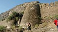
The Main Gate is located south of the hill, featuring well preserved woodwork.

The Manmad Gate is on the Northern side of the col facing Manmad city.

The Brahmani (Hindu) Caves are near the entrance gate to the upper plateau of Ankai fort. They are in ruins, but the idols of Jai and Vijay carved out of rock and the Shivinga can still be seen.

The Palace and Kashi Pond On the western edge of the plateau is a large palace in a dilapidated condition. Only the walls of the palace remain. Among the rock cut cisterns on the way to the palace is the Kashi pond, with a holy Tulsi pot engraved in rock placed in the center of the pond.

[5] There is a series of rock-cut water cisterns on the southern side of the fort. It takes about two hours to visit all the attractions on the fort.

20°11′14″N74°26′51.5″E / 20.18722°N 74.447639°E / 20.18722; 74.447639

See also

Related Research Articles

<span class="mw-page-title-main">Daulatabad Fort</span> 12th-century fort in Maharashtra, India

DaulatabadFort originally DeogiriFort, is a historic fortified citadel located in Daulatabad village near Chhatrapati Sambhajinagar, Maharashtra, India. It was the capital of the Yadavas, for a brief time the capital of the Delhi Sultanate, and later a secondary capital of the Ahmadnagar Sultanate.

<span class="mw-page-title-main">Aurangabad district, Maharashtra</span> District of Maharashtra in India

Aurangabad district, officially known as Chhatrapati Sambhaji Nagar district, is one of the 36 districts of the state of Maharashtra in western India. It borders the districts of Nashik to the west, Jalgaon to the north, Jalna to the east, and Ahmednagar to the south. The city of Aurangabad houses the district's administrative headquarters. The district has an area of 10,100 km2, of which 37.55% is urban and the rest is rural. Aurangabad District is a major tourism region in Marathwada.

<span class="mw-page-title-main">Nashik district</span> District of Maharashtra in India

Nashik district, also known as Nasik district, is a district in Maharashtra, India. The city of Nashik is the administrative headquarters of the district. Nashik is well known for the production of wine. Nashik is also known as Mini Maharashtra, because the climate and soil conditions of Surgana, Peth, Igatpuri resembles with Konkan. Niphad, Sinnar, Dindori, Baglan blocks are like Western Maharashtra and Yeola, Nandgaon, Chandwad blocks are like Vidarbha Region. Nashik is the biggest city in the district while Malegaon is the second biggest city. Manmad, Igatpuri, and Sinnar are some of the big cities situated in the Nashik District. Manmad is one of the biggest railway junctions in India while the city of Malegaon is famous for its powerloom.

<span class="mw-page-title-main">Mangi-Tungi</span> Twin-pinnacled peak in Maharashtra, India

Mangi-Tungi is a prominent twin-pinnacled peak with plateau in between, located near Tahrabad about 125 km from Nashik, Maharashtra, India. Mangi, 4,343 ft (1,324 m) high above sea level, is the western pinnacle and Tungi, 4,366 ft (1,331 m) high, the eastern. Mangi-Tungi is 30 km (19 mi) from the city of Satana.

<span class="mw-page-title-main">Lohagad</span> Fort in Maharashtra, India

Lohagad is one of the many hill forts of Maharashtra state in India. Situated close to the hill station Lonavala and 52 km (32 mi) northwest of Pune, Lohagad rises to an elevation of 1,033 m (3,389 ft) above sea level. The fort is connected to the neighboring Visapur fort by a small range. The fort was under the Lohtamia empire for the majority of the time, with a short period of 5 years under the Mughal empire.

<span class="mw-page-title-main">Chandwad</span> Town in Maharashtra, India

Chandwad (IPA:Cāndavaḍa) is a town located in the Nashik district in Maharashtra. It is 250 km from Mumbai. The 11th-century Jain Caves, Renuka devi mandir, Chandreshwar temple and Rangmahal are in Chandwad.

Nandgaon is a town and a municipal council in Nashik district in the Indian state of Maharashtra. It has a population of 23604 according to the 2011 census. Nandgaon is the headquarters of the Nandgaon taluka.

<span class="mw-page-title-main">Baglan taluka</span> Taluka/Tehsil in Maharashtra, India

Baglan is a taluka (tehsil) in Nashik District in the Indian state of Maharashtra. Sometimes Baglan Taluka is unofficially referred to as Satana, because of that city's dominance within the taluka.

<span class="mw-page-title-main">Tankai fort</span>

Tankai fort is a hill, part of the Satmala Range, with the ruins of a large Maratha hill fort on the peak. With Ankai Fort near this fort are known as Ankai-Tankai, the strongest hill fort in the Nashik district, rises about 900 feet above the plain and 3200 feet above the sea. It is located from Manmad in Yeola taluka of Nashik district in Maharashtra, India.

<span class="mw-page-title-main">Tringalwadi</span>

Tringalwadi fort is located in the Igatpuri taluka of Nashik district. It is located on the ancient trade route passing through Thal ghat. The fort is located near village Tringalwadi. The Tringalwadi irrigation dam which is close to the village was built in 1978.

<span class="mw-page-title-main">Harihar fort</span> Fort in Maharashtra, India

Harihar fort / Harshagad is a fort located 40 km from Nashik City, 48 km from Igatpuri, 40 km from Ghoti in Nashik district, of Maharashtra, India. It is an important fort in Nashik district, and was constructed to look upon the trade route through Gonda Ghat. It receives many visitors because of its peculiar rock-cut steps.

<span class="mw-page-title-main">Indrai fort</span> Historic building in Maharashtra, India

Indrai Fort / Indragiri Fort is a fort located 75 km from Nashik, in Nashik district, of Maharashtra. This fort though is an important fort in Nashik district but, it is less visited by the trekkers. In Chandwad taluka, there are 4 forts in a line on the Satmal hill range, the Chandwad fort, Indrai fort, Rajdher fort, and Koldher fort. This fort is easy to climb but requires 3 hours to reach the fort.

<span class="mw-page-title-main">Vikatgad</span>

Vikatgad / Peb Fort is a fort located 19 km (12 mi) from Karjat, in Raigad district, of Maharashtra. This fort is in continuation with the Malang gad, Tauli Hill and Chanderi fort of the Matheran Hill Range. Vikatgad is a favourite destination for one-day trekkers. The trek path to Vikatgad is along deep ravines and cliffs. Its closeness to Matheran and Neral attracts many trekkers on weekends. The forest department and local villagers are doing plantation and some restoration works on the fort. The altitude of Vikatgad, also known as Peb fort is 640 meters above sea level.

<span class="mw-page-title-main">Rajdher fort</span>

Rajdeher Fort (Marathi: राजधेर किल्ला) is a fort located 10 km (6.2 mi) from chandwad, Nashik district, of Maharashtra. This fort is an important fort in Nashik district.

<span class="mw-page-title-main">Chandwad fort</span>

Chandwad Fort is located 3 kilometres (1.9 mi) from Chandwad, Nashik district, of Maharashtra.

Hatgad Fort is a fort located 71 km (44 mi)from Nashik, Nashik district, of Maharashtra. The base village is Hatgad on the Nashik-Saputara Road. The nearest town is Saputara, which is 6 km from Hatgad village. It is a historic monument located in Maharashtra, India, south of the hill station of Saputara and near the border with Gujarat. It was built by the Maratha king Shivaji and is located at an elevation of about 3,600 feet. The way to reach the fort is through a trekking route via a narrow rocky path and car also go up to the stairs of fort. A statue of Lord Shivling is placed on the top of the fort.

<span class="mw-page-title-main">Pisola fort</span>

Pisola Fort is a fort located 125 km (78 mi) from Nashik, in the Nashik district of Maharashtra, India. This fort lies exactly on the borders of Dhule & Nashik District. One side is in Sakri Taluka & another is in Satana Taluka. Though this fort is an important fort in Nashik district, it is less visited by trekkers. In Satana taluka, there are four forts in a line on the Galna hill range, the Pisol fort, Dermal fort, Kankrala fort and Galna fort. This fort is easy to climb but requires one hour to reach the fort.

Trymbakgad Fort/Brahmagiri Fort is a fort located 30 km from Nashik, in Nashik district, of Maharashtra, India. This is an important fort in Nashik district. It is located on a hill adjoining the famous Trimbakeshwar temple.

<span class="mw-page-title-main">Hargad Fort</span>

Hargad Fort is located in the Baglan area of Nashik district. There are two main hill ranges in Baglan area, the Selbari range is south of the Dolbari hill range. These two ranges run parallel to each other in east-west direction. Hargad is located on Selbari hill range. All these forts were maintained to keep watch on the Burhanpur-Surat ancient commercial road. The road passes between the two hill ranges. Hargad fort is a small fort, close to Mulher fort. These are key forts situated between fertile lands of Khandesh and port city of Surat.

Javlya Fort is located 43 km from Nashik, Nashik district, of Maharashtra. Ravlya fort and Javlya fort are twin forts located on a single hill plateau, Ravlya on the west and Javlya on the east side of the hill plateau.

References

  1. James Fergusson; James Burgess (May 2013). The Cave Temples of India. Cambridge Library Collection. p. 480. ISBN   9781108055529 . Retrieved 19 December 2015.
  2. "Ankai-Tankai hill forts". Wondermondo. 14 June 2010. Retrieved 19 December 2015.
  3. "Nasik District Gazetteers". Cultural.maharashtra.gov.in. 31 March 1965. Retrieved 12 August 2022.
  4. "Ankai, Sahyadri, Shivaji, Trekking, Marathi, Maharastra". trekshitiz.com. Archived from the original on 16 April 2016.
  5. Book "Saad Sahydrichi-Bhatkanti killyanchi" by P.K. Ghanekar