Salher is a place located near Salher Village in Satana tehsil in Nashik district of Maharashtra, India.The old name of Salher was Gavalgarh. It is the site of the highest fort in the Sahyadri mountains and the second highest peak at 1,567 metres (5,141 ft) after Kalsubai in Maharashtra and 32nd highest peak in Western Ghats. This was a fort of the Maratha Empire. The money acquired after raiding Surat was brought to this fort first on its way to the Maratha capital forts.
Mulher is a village in the Nashik district of Maharashtra, India.

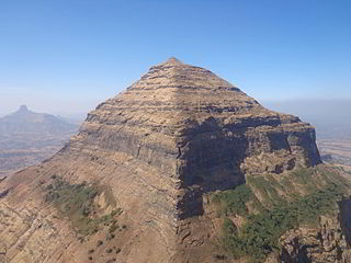
Tikona also known as Vitandgad, is the dominant hill fort in Maval in western India. It is located near Kamshet around 60 km from Pune. The village nearest to the fort is called Tikona-Peth. The 3500 foot high hill is pyramidal in shape and the name Tikona means "triangular".
Korigad is a hill fort located about 20 km (12 mi) south of Lonavla in Pune district, Maharashtra, India. Its date of construction is not known but likely predates 1500. It is about 923 m above sea level. The planned township of Aamby Valley is built over the fort's southern and eastern foothills. The closest village is Peth Shahpur, about 1 km (0.62 mi) north of the fort.

Baglan is a taluka (tehsil) in Nashik District in the Indian state of Maharashtra. Sometimes Baglan Taluka is unofficially referred to as Satana, because of that city's dominance within the taluka.
Madangad is a fort in the Nashik region of Maharashtra, India in the Kalsubai range.
Dhodap is one of the hill forts in Maharashtra state in India. Situated in Chandwad taluka in the Nashik district. the fort is 4829 ft above sea level. It is the site of the second-highest fort in the Sahyadri mountains after Salher. Dhodap hill is the second-highest hill peak in Maharashtra after Kalsubai and Salher and the 29th highest peak in Western Ghats.

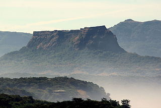
Kenjalgad Fort in Wai, Maharashtra is a fort eleven miles (18 km) north-west of Wai. It is located on the Mandhardev spur of the Mahadev hill range. The fort is visible from quite a long distance as a stone scarp 30–40 feet high rising as a cap on the irregular hill. The fort is rhomboid in shape with 388m long axis and 175m short axis.
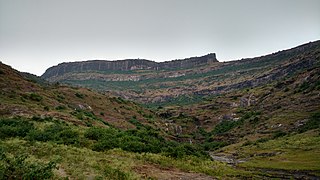
Selbari is a mountain range located in Nashik District in Maharashtra, India. Spanning east-west the hills form the northernmost extent of the Sahyadris and serve as a natural boundary between Nashik District and Dhule district. The range is gifted with a number of peaks including the only two-pinnacled peak of Mangi-Tungi rising to a considerable height of up to 1,331 meters.
Nhavigad is also called as Nhavagad or Ratangad. It is located in the Baglan area of Nashik district. There are two main hill ranges in Baglan area the Selbari range and Dholbari range. These two ranges run parallel to each other in east-west direction. Nhavigad is located in Selbari mountain range. All these forts were maintained to keep watch on the Burhanpur-Surat ancient commercial road. The road passes between the two hill ranges. Nhavigad is a small fort, but very difficult to climb.

Mora fort is located in the Baglan area of Nashik district. There are two main hill ranges in Baglan area, the Selbari range is south of the Dolbari hill range. These two ranges run parallel to each other in east-west direction. Moragad is located on Selbari hill range. All these forts were maintained to keep watch on the Burhanpur-Surat ancient commercial road. The road passes between the two hill ranges. Mora fort is a small fort, east of Mulher fort.

"Bhaskargad Fort, alternatively known as Basgad Fort, is a hill fort situated within the Nashik district of Maharashtra, India. Part of the Trimbak hill range, it lies in proximity to Harihar Fort. Located approximately 48 kilometers away from Igatpuri, Bhaskargad Fort is recognized as a favored site for activities such as trekking and hiking."

Vikatgad / Peb Fort is a fort located 19 km (12 mi) from Karjat, in Raigad district, of Maharashtra. This fort is in continuation with the Malang gad, Tauli Hill and Chanderi fort of the Matheran Hill Range. Vikatgad is a favourite destination for one-day trekkers. The trek path to Vikatgad is along deep ravines and cliffs. Its closeness to Matheran and Neral attracts many trekkers on weekends. The forest department and local villagers are doing plantation and some restoration works on the fort. The altitude of Vikatgad, also known as Peb fort is 640 meters above sea level.
Rajdeher Fort (Marathi: राजधेर किल्ला) is a fort located 10 km (6.2 mi) from chandwad, Nashik district, of Maharashtra. This fort is an important fort in Nashik district.

Asheri Fort / Asheri is a fort located 102 km from Mumbai and 88 km from Thane. It is in Palghar district, of Maharashtra. This fort is an important fort in Palghar district. The fort is located on the hills near Mendhavan Khind on Mumbai-Ahmedabad highway. The base village Khodkona is a very small tribal village. The Fort restoration is done by the local villagers.
Ahivant Fort is a fort located 55km from Nashik, in Nashik district, of Maharashtra. This fort is an important fort in Nashik district. The three forts Achala, Ahivant, and Mohandar are very close by. The other two forts were constructed to guard the Ahivant fort.
Achala Fort is a westernmost fort in the Satmala hill range. It is located 55km from Nashik, in Nashik district, of Maharashtra. This fort is adjoining the Ahivant Fort. The three forts Achala, Ahivant, and Mohandar are very close by. The Achala and Mohandar forts were constructed to guard the Ahivant fort. Captain Briggs has described it as a large hill, whose ascent is very easy till it reaches the top where it is very steep.

Hargad Fort is located in the Baglan area of Nashik district. There are two main hill ranges in Baglan area, the Selbari range is south of the Dolbari hill range. These two ranges run parallel to each other in east-west direction. Hargad is located on Selbari hill range. All these forts were maintained to keep watch on the Burhanpur-Surat ancient commercial road. The road passes between the two hill ranges. Hargad fort is a small fort, close to Mulher fort. These are key forts situated between fertile lands of Khandesh and port city of Surat.
Konkandiva Fort (transliteration: Konkandiva Qilа̄) is a fort located 70 km from Pune in Maharashtra. This fort is on the boundary of Raigad and Pune district. The fort was important as a surveillance fort to keep watch on the possible attack on the Raigad fort through Ghol Village side along the Mutha river.
Kurdugad Fort is a fort located 143 km (89 mi) from Mumbai and 113km from Pune in Raigad district, of Maharashtra. This fort was an important fort in Raigad district as a watch over for the trade route from Pune to coastal ports. The fort is surrounded by thick forest and hill slopes.

