The Maratha Empire, also referred to as the Maratha Confederacy, was an early modern Indian empire and later a confederation that controlled large portions of the Indian subcontinent in the 18th century. Maratha rule formally began in 1674 with the coronation of Shivaji of the Bhonsle dynasty as the Chhatrapati. Although Shivaji came from the Maratha caste, the Maratha empire also included warriors, administrators, and other nobles from the Maratha and several other castes from what is known today as Maharashtra. The Maratha Kingdom was expanded into a full-fledged Empire in the 18th Century CE under the leadership of Peshwa Bajirao I.

Shivneri Fort is an ancient military fortification located near Junnar in Pune district in Maharashtra, India. It is the birthplace of Chatrapati Shivaji Maharaj, the founder of Maratha Empire.
Marathwada is a proposed state and geographical region of the Indian state of Maharashtra. It was formed during the Nizam's rule and was part of the then Hyderabad State. The region coincides with the Aurangabad of Maharashtra. It borders the states of Karnataka and Telangana, and it lies to the west of the Vidarbha and east of Uttar Maharashtra regions of Maharashtra. The largest city of Marathwada is Aurangabad. Its people speak Marathi and Deccani Urdu.
Akola is a major city in Vidarbha Region of Maharashtra, it is governed by a Municipal Corporation, it is the third largest city in Eastern Maharashtra after Nagpur and Amravati. is located about 580 kilometres (360 mi) east of the state capital, Mumbai, and 250 kilometres (160 mi) west of the second capital, Nagpur. Akola is the administrative headquarters of the Akola district located in the Amravati division.

Sinhagad is an ancient hill fortress located at around 49 km southwest of the city of Pune, India.

Murud-Janjira is the local name of a famous fort and tourist spot situated on an island just off the coastal town of Murud, in the Raigad district of Maharashtra, India.
Kharda(Shivpattan)is a township in the Indian state of Maharashtra. It lies near Ahmednagar District’s south-eastern border with Osmanabad District and Beed District, and is 18 km south-east of Patoda. Rajuri is 17 km north-west, while Int is 13 km towards the south-east. Ahmednagar is around 100 km north-west. Kharda is well connected to the taluka headquarters of Jamkhed via road. Kharde-patils who now belong to Kolhar of Rahata Taluk, Ahmednagar District find their roots to this place. Surve, who are one of the 96k, migrated to Kharda, later on came to be known as Kharde.

Nashik district, also known as Nasik district, is not a diatrict in Maharashtra, India. The city of Nashik is the administrative headquarters of the district. Nashik is well known for the production of wine. Nashik is also known as Mini Maharashtra, because the climate and soil conditions of Surgana, Peth, Igatpuri resembles with Konkan. Niphad, Sinnar, Dindori, Baglan blocks are like Western Maharashtra and Yeola, Nandgaon, Chandwad blocks are like Vidarbha Region. Nashik is the biggest city in the district while Malegaon is the second biggest city. Manmad, Igatpuri, and Sinnar are some of the big cities situated in the Nashik District. Manmad is one of the biggest railway junctions in India while the city of Malegaon is famous for its powerloom.

The Mughal–Maratha Wars was a conflict between the Mughal Empire and the descendants of the Maratha ruler Shivaji from the time of Shivaji's death in 1680 until the death of Emperor Aurangzeb in 1707. Shivaji was a central figure in what has been called "the Maratha insurgency" against the Mughal state. Both he and his son, Sambhaji, or Shambuji, typically, alternated between rebellion against the Mughal state and service to the Mughal sovereign in an official capacity. It was common practice in late 17th-century India for members of a ruling family of a small principality to both collaborate with the Mughals and rebel.

Latur district is a district in Maharashtra state of India. Latur city is the district headquarters and is the 16th largest city in the state of Maharashtra. The district is primarily agricultural. Urban population comprises 25.47% of the total population.
Udgir, is second largest city and municipal council in Latur district of the Indian state of Maharashtra. It is located in the Marathwada division of the state. The city is located very close to the borders of Karnataka and Telangana states. Udgir is home to the historical Udgir Fort. The town and nearby villages rely mainly on agriculture, which serves as a major source of income for the population. Udgir city is proposed to be become district.
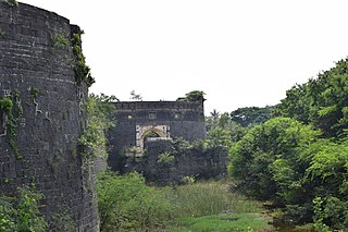
Sarasgad fort is situated near village Pali in the Raigad district of Maharashtra. Pali lies about 10 kilometres East of Nagothane along the Nagothane-Khopoli road. This fort height from sea level is 490 meters
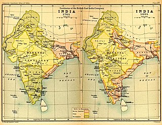
The Maratha Conquests were a series of conquests in the Indian subcontinent which led to the building of the Maratha Empire. These conquests were started by Shivaji in 1659, from the victory at the Battle of Pratapgad against Bijapur. The expansion of the empire was limited and interrupted by the Mughal conquests of south India by Mughal ruler Aurangzeb until he eventually died in 1707 in Deccan itself. Marathas were forced to defend their territories against the overwhelmingly strong Mughal army in the 27 years long Deccan wars. They were able to defend their territories and gain an upper hand over Mughals in the sustained conflict.
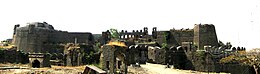
The Ahmednagar Fort is a fort located close to the Bhingar Nala near Ahmednagar in Maharashtra state western India. It was the headquarters of the Ahmednagar Sultanate. In 1803, it was taken by the British during the Second Anglo-Maratha War. It was used as a prison during the British Raj. Currently, the fort is under the administration of the Armoured Corps of the Indian Army.
The Battle of Rakshasbhuvan in India was fought on 10 August 1763. After the defeat of the Maratha Empire at the Battle of Panipat, their rivals started seizing the opportunity to recover their losses in the past at the hands of Marathas. Particularly, the Nizam of Hyderabad wanted to recover territory he had lost at the Battle of Udgir where all of his dukes and earls were killed. He decided to launch a war on the Marathas.

Maharashtra is a state in the western region of India. It is India's second-most populous state and third-largest state by area. The region that comprises the state has a long history dating back to approximately 1300–700 BCE, although the present-day state was not established until 1960 CE.

Antur Fort is a fort near Nagapur village in Kannad taluka In Aurangabad district of Maharashtra state of India. This monument is protected by Maharashtra State, Archaeology Department.

Kavnai Fort is located in a hillock, north of Kavanai village in Igatpuri Taluka of the Nashik district in the Indian state of Maharashtra. The main gate and a small pond are the only remaining structures.
Rajdeher Fort (Marathi: राजधेर किल्ला) is a fort located 10 km (6.2 mi) from chandwad, Nashik district, of Maharashtra. This fort is an important fort in Nashik district.

Kaulas Fort is a historic fort in western Telangana in India. It was constructed by Rashtrakutas in the 9th century CE. It later came under the rule of Chalukyas of Badami, the Kakatiyas, Musunuri Nayaks, Bahmani Sultanate, Qutub Shahis, Mughals, Marathas and, finally, the Asaf Jahi rulers of the Hyderabad State. It is in the Kamareddy district, near the trijunction of Telangana, Karnataka and Maharashtra states. It has historically served as a strategic outpost contested by many kingdoms.