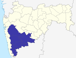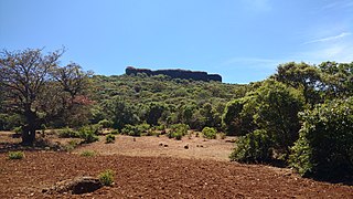
Satara district is a district of Maharashtra state in western India with an area of 10,480 km2 (4,050 sq mi) and a population of 3,003,741 of which 14.17% were urban. Satara is the capital of the district and other major towns include Medha, Wai, Karad, Koregaon, Dahiwadi, Koynanagar, Rahimatpur, Phaltan, Mahabaleshwar, Vaduj and Panchgani. This district comes under Pune Administrative Division along with Pune, Sangli, Solapur and Kolhapur. The district of Pune bounds it to the north, Raigad bounds it to the north-west, Solapur the east, Sangli to the south, and Ratnagiri to the west.

Pune division is one of the six administrative divisions of India's Maharashtra state. Pune Division is bound by Konkan Division to the west, Nashik Division to the north, Aurangabad Division to the east, and Karnataka State to the south.

Phaltan is a town, a tehsil, and a municipal council in the Satara district in the Indian state of Maharashtra. The town is about 59 kilometres (37 mi) northeast of the city of Satara and about 110 km from Pune.

Koregaon is a census town and headquarters for the surrounding Koregaon Taluka in the Satara subdivision of Satara district in the Indian state of Maharashtra. It is situated on the Satara-Pandarpur road about 18 km east of Satara city, about 120 km from Pune and 267 km from Mumbai. The Koregaon railway station, situated on the Pune - Miraj line, is 2 kilometers outside the town. At a stone's throw from the railway station is Koregaon Bus Station.

Khatav is a town and taluka located in the Phaltan subdivision of the Satara district, India. Khatav has a population of about 22346.

Tadawale Sammat Wagholi is a small town and gram panchayat in Koregaon taluka, Satara district, in the Indian province of Maharashtra.
Nimbalkar is a Maratha clan, which derives its surname from the forest of Nimbalak in Phaltan taluka, Satara district, Maharashtra, India.

Kamalgad, also called Bhelanja or Kattalgad is a square hill fort in Wai Taluka in [[Maharashtra]India.

Hingangaon is a small town and Gram panchayat in Phaltan Tehsil, District Satara of Maharashtra, India. It is strategically situated in mountainous parts of the region and is approximately 6–8 km from the Pune-Pandharpur Highway and Phaltan-Satara Roads mounted on Deccan Plateau. It is one of the renowned villages in Tehsil.

Sakharwadi is a town and Gram panchayat of Phaltan tehsil, Satara district, Maharashtra, India. It is situated at about 15 kilometres (9.3 mi) north-east of Phaltan city and approximately 60 kilometres (37 mi) north-west of Satara city.

Khandala is a town and taluka in the Satara district in the Indian state of Maharashtra.

Bhairavgad is a fort in India, twenty miles south-west of Patan, Satara district of Maharashtra. The fort is situated on a peak of Sahyadri range. The fort has a temple of Bhairav (Shiva); from which it gets its name. It is located at an altitude of about 1000 meters.

Phaltan State was one of the non-salute Maratha princely states of British India. It was ruled by the Nimbalkar clan of the Marathas. It was under the central division of the Bombay Presidency, under the states of the Kolhapur-Deccan Residency, Satara Agency, and later the Deccan States Agency. Its capital was Phaltan town, located in present-day Maharashtra.

Padali is a census village in the Satara district, in the Indian state of Maharashtra. It is surrounded by a Mountains on its three sides. There is a big temple of Heljaidevi Mandir at Village. Agriculture is the main occupation in the village with more than 75% of the total area being used for agricultural activities.
Man of Maharashtra Vidhan Sabha is one of the constituencies located in the Satara district.
Phaltan of Maharashtra Vidhan Sabha is one of the constituencies located in the Satara district. This constituency presently, after delimitation of Legislative Assembly constituencies in 2008, is reserved for the candidates belonging to the SC

Kalyangad Fort/Nandgiri is in the taluka Koregaon)of Satara district of Maharashtra. The fort stands at the end of a spur of the Mahadev range running south-west from the villages of Vikhale and Bhadle, eight miles north of Koregaon and about fourteen miles north-east of Satara. Its elevation is 3,537 feet above sea level.

Banawadi is a census village of Satara district in the Indian state of Maharashtra. It is situated near to the Satara Phaltan state highway, about 21 km north of Satara, about 108 km from Pune and 220 km from Mumbai.
Adarki is a village in Phaltan Taluka in the Satara District of Maharashtra State, India. At the 2011 census, the village had a population of 2704.

Garavadi (Ramnagar) is a census village in the Satara district, which is located in the India state of Maharashtra. There are a total of approximately 240 families residing within its borders. The village is located in the Khatav Tehsil of Satara district in Maharashtra, India. It is 32 km away from the sub-district headquarters of Vaduj, and 54 km away from the district headquarters of Satara. Research from 2009 shows that Garavadi village is also classified as a gram panchayat. According to the India Census in 2011, the village was recorded to have a population of 997, 478 of which were males, and the other 519 females.


