
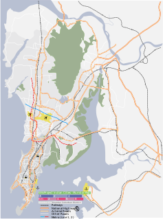
Alibag is a coastal town and a municipal council in Raigad District of Maharashtra, India. It is the headquarters of the Raigad district and is south of the city of Mumbai. Alibag is part of Mumbai Metropolitan Region and is situated at a distance of about 96km from Mumbai and 143km from Pune.
Panvel is a locality in Raigad district of Maharashtra in India. It is highly populated due to its closeness to Mumbai. Panvel is located in the Mumbai Metropolitan Region. Panvel is the first Municipal Corporation in Raigad and the 27th Municipal corporation of Maharashtra State.

Chaul is a former city of Portuguese India, now in ruins. It is located 60 km south of Mumbai, in Raigad District of Maharashtra state in western India.

Fort Bassein, also known as the Vasai Fort or Corte de Baçaim meaning "Court of Bassein" in Indo-Portuguese creole, वसई चा किल्ला in Maharashtrian Konkani, is a ruined fort in the town of Vasai (Bassein) in the Palghar district of Konkan division in Maharashtra, India. The name "Bassein" is the anglicised version of the Portuguese Baçaim, which is itself a derivation of an apparently native name that may have a connection to the tribal Vasa Konkani people of the North Konkan region, extending from Mumbai (Bombay) into "South Gujarat". Bassein's alternate official name is Vasai.
The Battle of Vasai or the Battle of Bassein was fought between the Marathas and the Portuguese rulers of Vasai, a town lying near Mumbai (Bombay) in the present-day state of Maharashtra, India. The Marathas were led by Chimaji Appa, a brother of Peshwa Baji Rao I. Maratha victory in this war was a major achievement of Baji Rao I's reign.

The Kundalika is a small river flowing from the hills of Sahyadri to the Arabian Sea. This river originates at a small town called Bhira in the Indian state of Maharashtra, 150 km south east of Bombay (Mumbai). The important towns located on the banks of Kundalika are Kolad, Korlai, Chaul, Roha and Salav.

Kolaba Fort is an old military fortification in India. It is situated in the sea at a distance of 1–2 km from the shores of Alibag, 35 km south of Mumbai, in the Konkan region of Maharashtra, India. It is a popular tourist destination and a protected monument.
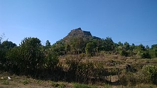
Sarasgad, fort is situated near village Pali in the Raigad district of Maharashtra. Pali lies about 10 kilometres East of Nagothane along the Nagothane-Khopoli road.This fort height from sea level is 490 meters

Raigad is a hill fort situated in Mahad, Raigad district of Maharashtra, India. Many constructions and structures that we see on raigad were built by chatrapati Shivaji when he made it his capital in 1674 when he was crowned the King of the Maratha Kingdom which later developed into the Maratha Empire, eventually covering much of western and central India.

Torna Fort, also known as Prachandagad, is a large fort located in Pune district, in the Indian state of Maharashtra. It is historically significant because it was the first fort captured by Chatrapati Shivaji Maharaj in 1646, at the age of 16, forming the nucleus of the Maratha empire. The hill has an elevation of 1,403 metres (4,603 ft) above sea level, making it the highest hill-fort in the district. The name derives from Prachanda and gad.

Karnala Fort is a hill fort in Raigad district, Maharashtra, India, about 10 km from Panvel city. Currently it is a protected place lying within the Karnala Bird Sanctuary. It was a place of strategic importance since it overlooked the Bor pass, which connected the Konkan coast to the interior of Maharashtra on the main trade route between these areas.

Vijaydurg, the oldest fort on the Sindhudurg coast, was constructed during the regime of Raja Bhoja II of the Shilahar dynasty and restructured by Shivaji.

Shirgaon is a village in the Palghar district of the state of Maharashtra, India. It can be reached by State Transport busses or other public transportation from Palghar Station on the Mumbai - Ahmedabad train route. It has an extremely long beach with Kelva Beach on one side and Satpati on the other.
Sankshi Fort सांक्शी किल्ला This fort is located in Pen Taluka of Raigad district of Maharashtra. It is 9 kilometres (5.6 mi) from Pen.

Birwadi fort is hill fortress located in the village of Birwadi in Roha taluka, Raigad district, Maharashtra, India. Birwadi village is about 3 km away from Chanera village, which is on the Roha–Salav road. The fort looks like a small hillock from a distance.

Dronagiri Fort is a fort in Raigad district, Maharashtra, India.
Talagad Fort is located 18 km south of the Roha town on Roha-Tala-Indapur road. This fort is at an altitude of 1000feet. This fort is in form of a narrow strip 20mt in width. This fort is situated on a narrow spur guarded by fortification. This fort served to keep watch on the enemy and the trade route from Maval to the sea ports around. Also this fort was used to keep check on the activity of sidhhis of janjira. Ghosalgad fort is also visible from this fort.

Surgad, is a hill fort located in a spur, fragmented from the Sahyadri ranges of Maharashtra. The fort is situated near Roha, next to the village of Gherasurgad in the Raigad district. This fort was an observation fort, which guarded the trade route along the Kundalika river from Sudhagad to Revdanda fort.

Peb Fort / Vikatgad Fort(Marathi: पेब किल्ला / विकटगड) is a fort located 19km from Karjat, in Raigad district, of Maharashtra. This fort is in continuation with the Malang gad, Tauli Hill and Chanderi fort of the Matheran Hill Range. Vikatgad is a favourite destination for one-day trekkers. The trek path to Vikatgad is along deep ravines and cliffs. Its closeness to Matheran and Neral attracts many trekkers on weekends. The forest department and local villagers are doing plantation and some restoration works on the fort.
Sambhaji's invasion of Goa refers to the Maratha invasion of Portuguese controlled Goa. The battles were fought between the Maratha Empire and the Portuguese Empire. The Portuguese viceroy Francisco de Távora attacked the Ponda Fort in 1683 which resulted in Sambhaji launching an all out attack on Goa. Sambhaji stayed there for more than a month. Sambhaji stormed the colony and took its many forts. Sambhaji retreated from Goa on 2 January 1684 to avoid the large mughal army under prince Muazzam. The campaign was a successful one for Sambhaji. The Marathas then made peace with the Portuguese at the treaty of Mardangad.

