Korlai Fort

Last updated

Korlai Fort
Morro de Chaul [1]
Part of Portuguese India
Raigad district, Maharashtra
Portuguese church of Korlai fort.jpg
Ruins of the Portuguese church in Korlai
India Maharashtra location map.svg
Red pog.svg
Korlai Fort
India location map.svg
Red pog.svg
Korlai Fort
Coordinates 18°32′9″N72°54′29″E / 18.53583°N 72.90806°E / 18.53583; 72.90806
TypeIsland fort
Site information
OwnerGovernment of India
Controlled by  Ahmadnagar (1521-1594)
Flag of Portugal (1578).svg  Portugual (1594-1739)
Flag of the Maratha Empire.svg  Maratha (1739-1818)
Flag of the United Kingdom.svg  United Kingdom Flag of India.svg  India (1947-)
Open to
the public
Yes
ConditionRuins
Site history
Built1521
Built byDom Filipe Mascarenhas
MaterialsStone
Demolished1594

Korlai Fort is a colonial fort in the Raigad district of Maharashtra, India. [2] Formerly a part of Chaul in Portuguese India, [3] the structure is a specimen of Portuguese colonial architecture. [2] It was built as a companion to the fort at Chaul, at this strategic position the Portuguese could use it to defend their province which stretched from Korlai to the Fort Bassein. [4] Vestiges of the Portuguese occupation are manifested in the distinct dialect of the Korlai villages inhabitants which is a Luso-Indian creole called Korlai Portuguese Creole.

Contents

History

Old Map of Chaul and environs Fortress of Chaul- Plans of Plazas and Forts of Portuguese Possessions in Asia and Africa WDL1057.png
Old Map of Chaul and environs

This fort was built in 1521 by the Portuguese with the permission of the Ahmednagar sultanate. In 1521, taking advantage of the confusion in the aftermath of the death of the Burhan Nizam, the Portuguese tried to take over the fort. [5] However the sultan retaliated and sent some of his best men to reclaim the fort. Subsequently, a truce was reached in which the Ahmednagar sultanate occupied the island and no further fortification of the island took place. Only a wooden cross remained on the island as a sign of its former rulers.

However, in 1594, Abranches, a Portuguese captain with 1,500 soldiers and 1,500 natives took possession of the fort. The besieged soldiers of the Sultanate tried to block their way by putting a dead elephant at the main gate and a dead horse at the inner gate. But in the end they had to surrender. [6] [5] The Portuguese won the fort but not having enough men to stand guard there chose to destroy it [5] leaving only the central tower and a battery intact.

Before its destruction, Korlai had been described by travelers as a "magnificent fortress as strong as any other in the world". [5] On the inland side - the only place where it was susceptible to be attacked - it was protected by a ditch and could only be accessed by a drawbridge. The main entrance was guarded by a bronze lion and the highest tower by a bronze eagle. It housed 7,000 horses and as much men.

Some parts of it were rebuilt later but now had a garrison of only 50 men. [5] The church within the fort was used for worship on Sundays and holidays. Korlai fort was also strategically very important as it guarded the mouth of the bay. Chhatrapati Sambhaji Maharaj, the son of Chhatrapati Shivaji Maharaj, tried to take it over but failed [7] and had to withdraw his forces on 6 December 1687. [8] The fort was taken by the Marathas who held it from 1739 to 1818.
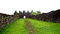
Major features

Inscription on top of the main entrance Korlai fort inscription.jpg
Inscription on top of the main entrance
a view of korlai village from korlai fort Korlai1.jpg
a view of korlai village from korlai fort
a view of korlai village from korlai fort Korlai.jpg
a view of korlai village from korlai fort
Korlai fort Korlai2.jpg
Korlai fort
Korlai fort Korlai3.jpg
Korlai fort
Korlai fort Korlai4.jpg
Korlai fort
Korlai fort Korlai5.jpg
Korlai fort
Korlai fort Korlai6.jpg
Korlai fort

The fort is 2,828 feet long, and its average breadth is eighty-nine feet. The enclosing wall is 5' 3" high and has 305 battlements for guns. It is entered by eleven gates - four are outer and seven are inner. At the north point, within pistol-shot of the main battery, is the water cistern named Santa Cruz, major source of water. The area within the fort walls is divided into three enclosures by two lines of bastioned fortifications. Each of the seven bastions bears the name of a saint. The two westward bastions are named São Diego (after Didacus of Alcalá) and São Francisco (after Francis of Assisi). [7] The others are São Pedro, São Inácio, and São Filipe. [5]

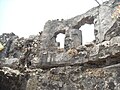
The top of the hill is bastioned as well and is surrounded by a parapet. It has a large rainwater cistern with three mouths, each one foot wide, and the ruins of the magazine and a church. [9] The church was built in 1630 for the use of the army [7] and was functional until 1728.

There are three Portuguese inscriptions. One, over a doorway in the centre and highest part of the fort (see picture), reads as follows:

This castle was commanded to be built by the Viceroy of India Dom Filipe Mascarenhas in November of the year 1646 and Fernão Miranda Henriques being Captain of Chaul, and was finished in May 1680, Cristóvão de Abreu de Azevedo being Captain of this fort.

The inscription is surmounted by a cross with a coat of arms having the Portuguese stars in the centre and surrounded by seven castles. Other inscriptions over the main entrance and over an altar in the chapel are worn out and undecipherable. [5] During the brief Maratha rule, some of the names of the bastions were changed but now the only indication of their presence is some dismantled shrines.

Forest

The hill slopes surrounding the fort are in control of the Maharashtra Forest department. Originally trees of teak were planted on the eastern slopes. Later, in 1996, plantation of Casuarina , cashew and Acacia auriculiformis was done to check erosion.

How to reach

It is easily approachable by road. The road from Korlai bus stop ends at the Lighthouse. The fort has three entrance. The entrance from western side is the easiest way, it is from the Lighthouse side. Climbing few steps one reaches in the middle of the fort. The entrance from the eastern side is a tedious walk of 20 minutes. This route is the main route and the entrance is through main gate, but this route is not recommended in rainy season as this is less used route. The entrance from the port side or northern side is good one. One can reach there by walking along a path from the light house. There is ample of water on the topmost fortification, so a night halt can easily be made.

Rail

The nearest railway station is at Roha which is 42 km from the fort.

Road

Korlai is around 117 km south of Mumbai via State Highway 104 and 24 km from Alibag via State Highway 91.

Where To Stay

Less than 30 minutes from Korlai Fort are private 2-bedroom beach villas. Adorned in hues reminiscent of Goan and Portuguese architecture, these private villas are perched on a secluded stretch of Korlai beach with no permanent habitation for half a kilometer on either side. With nothing but the moonlight to keep company, it is the perfect spot for tourists to unwind and reconnect. The best and cheapest way to enjoy the real taste of sea-fort is staying in the abandoned church on the fort. The trekkers should carry a sleeping bag, torch, and drinking water for a night stay. The nearest Village is Chaul & Revdanda having all types of hotels, Homestays. recommended hotels as Archangel homestay, Fern Sylvanus resort, Awesome Cottages, Gokul cottage, Vasundhara Cottage & many more.

Related Research Articles

<span class="mw-page-title-main">Sambhaji</span> Indian king and Second Chhatrapati of the Maratha Empire

Sambhaji, also known as Shambhuraje was the second Chhatrapati of the Maratha Empire, ruling from 1681 to 1689. He was the eldest son of Shivaji, the founder of the Maratha Empire. Sambhaji's rule was largely shaped by the ongoing wars between the Maratha Empire and the Mughal Empire, as well as other neighbouring powers such as the Abyssinians of Janjira, Wadiyars of Mysore and the Portuguese Empire in Goa. After Sambhaji's death, his brother Rajaram I succeeded him as the next Chhatrapati and continued the Mughal–Maratha Wars.

<span class="mw-page-title-main">Peshwa</span> Second highest office and title in the Maratha empire

The Peshwa was second highest office in the Maratha Confederacy, next in rank and prestige only to that of the Chhatrapati. Initially serving as the appointed prime minister in the Maratha empire, the office became hereditary after the death of Shahu in 1749. During the reign of Shahu, the office of Peshwa became incredibly powerful and the Peshwas came to be the de facto rulers of the Maratha empire. However following the defeat of the Marathas in 1761, the office of the Peshwa became titular as well and from that point onwards served as the ceremonial head of the Confederacy underneath the Chhatrapati.

Revdanda is a village near Alibaug, Raigad District, Maharashtra. It is the site of the medieval 'Chaul harbor'.

<span class="mw-page-title-main">Fort Vasai</span> Fort in Vasai, Maharashtra, India

Fort Vasai is a ruined fort of the town of Vasai (Bassein), Palghar, Maharashtra, India. The structure was formally christened as the Fort of St. Sebastian in the Indo-Portuguese era. The fort is a monument of national importance and is protected by the Archaeological Survey of India.

<span class="mw-page-title-main">Junnar</span> City in Maharashtra, India

Junnar is a city in the Pune district of the Indian state of Maharashtra. The city has history dating back to the first millennium. The nearby fort of Shivneri was the birthplace of Maratha king Shivaji, the founder of the Maratha Empire. Junnar was declared the first tourism taluka in Pune district by the government of Maharashtra on 9 January 2018.

<span class="mw-page-title-main">Arnala fort</span>

Arnala Fort is built on a small island off the port town of Arnala, located around 13 km north of Bassein, Maharashtra, India. Being an island fort, it is also called Jaldurg or Janjire-Arnala. The Marathas who build the present fort called it Janjire Arnala.

Murud is a town and a municipal council in Raigad district in the Indian state of Maharashtra. Situated at a distance of 150 km (93 mi) from Mumbai, Murud is a tourist destination. The Palace of Nawab is located in Murud. The palace was built in 1885 for administration purposes. The palace is still owned by the descendants of the Nawab and is a private property.

<span class="mw-page-title-main">Kolaba Fort</span>

Kolaba Fort located at Alibag beach is an old fortified maritime base in Alibag, Konkan, India. It is situated in the sea at a distance of 1–2 km from the shores of Alibag, 35 km south of Mumbai, in the Konkan region of Maharashtra, India. It is a popular tourist destination and a protected monument.

<span class="mw-page-title-main">Raigad Fort</span> Hill fort in Maharashtra, India

Raigad, situated in the Raigad district of Maharashtra, India, is a hill fort located in the town of Mahad. It is one of the strongest fortresses on the Deccan Plateau and was historically referred to as Rairee or Rairy fort.

<span class="mw-page-title-main">Purandar Fort</span> Fort in Maharashtra, India

Purandar Fort is a mountain fort in Pune district in Western Indian state of Maharashtra, India. The fort stands at 1,374 metres (4,508 ft) above the sea level in the Western Ghats, 50 kilometres (31 mi) to the southeast of Pune.

<span class="mw-page-title-main">Panhala Fort</span> Medieval fort in Maharashtra, India

Panhala fort, is located in Panhala, 20 kilometres northwest of Kolhapur in Maharashtra, India. It is strategically located looking over a pass in the Sahyadri mountain range which was a major trade route from Bijapur in the interior of Maharashtra to the coastal areas. Due to its strategic location, it was the centre of several skirmishes in the Deccan involving the Marathas, the Mughals and the British East India Company, the most notable being the Battle of Pavan Khind. Here, the queen regent of Kolhapur, Tarabai Ranisaheb, spent her formative years. Several parts of the fort and the structures within are still intact. It is also called as the 'Fort of Snakes' as it is zigzagged in shape.

<span class="mw-page-title-main">Karnala Fort</span> Fort in India

Karnala Fort is a hill fort in Raigad district, Maharashtra, India, about 10 km from Panvel city. Currently it is a protected place lying within the Karnala Bird Sanctuary. It was a place of strategic importance since it overlooked the Bor pass, which connected the Konkan coast to the interior of Maharashtra on the main trade route between these areas.

<span class="mw-page-title-main">Ahmednagar Fort</span>

The Ahmednagar Fort is a fort located near to the Bhingar Nala near Ahmednagar in Maharashtra. It was the headquarters of the Ahmednagar Sultanate. In 1803, it was taken by the British during the Second Anglo-Maratha War. It was used as a prison during the British Raj. Currently, the fort is under the administration of the Armoured Corps of the Indian Army.

<span class="mw-page-title-main">Vijaydurg Fort</span> Fort located in Vijaydurg

Vijaydurg, the oldest fort on the Sindhudurg coast, was constructed during the regime of Raja Bhoja II of the Shilahar dynasty and restructured by Chhatrapati Shivaji Maharaj.

<span class="mw-page-title-main">Avchitgad</span>

<span class="mw-page-title-main">Architecture of Maharashtra</span> Architectural style of the state of Maharashtra and Maharashtrian people

Maharashtra state in India is known for its Famous caves and cliffs. It is said that the varieties found in Maharashtra are wider than the caves and rock-cut architecture found in the rock cut areas of Egypt, Assyria, Persia and Greece. The Buddhist monks first started these caves in the 2nd century BC, in search of serene and peaceful environment for meditation, and they found these caves on the hillsides.

<span class="mw-page-title-main">Maratha Navy</span> Combined naval force of Maratha Empire

The Maratha Navy was the naval wing of the armed forces of the Maratha Empire, which existed from around mid-17th century to mid-18th century in the Indian subcontinent.

<span class="mw-page-title-main">Surgad</span>

Hatgad Fort is a fort located 71 km (44 mi)from Nashik, Nashik district, of Maharashtra. The base village is Hatgad on the Nashik-Saputara Road. The nearest town is Saputara, which is 6 km from Hatgad village. It is a historic monument located in Maharashtra, India, south of the hill station of Saputara and near the border with Gujarat. It was built by the Maratha king Shivaji and is located at an elevation of about 3,600 feet. The way to reach the fort is through a trekking route via a narrow rocky path and car also go up to the stairs of fort. A statue of Lord Shivling is placed on the top of the fort.

Sarjekot Fort is an old military fortification in India. it is situated very close to the Malvan.It is located in the Arabian Sea close to the Malvan town in Sindhudurg District of Maharashtra state.

References

  1. "Chaul a Portuguese town in India".
  2. 1 2 Kapadia, Harish (2004). Trek the Sahyadris. Indus Publishing. p. 72. ISBN   81-7387-151-5 . Retrieved 4 February 2009.
  3. "Journal of the Bombay Natural History Society". v4. Bombay Natural History Society. 1889: 291. Retrieved 4 February 2009.{{cite journal}}: Cite journal requires |journal= (help)
  4. Indica. Saint Xavier's College, Bombay Heras Institute of Indian History and Culture. 2004. Retrieved 5 February 2009.
  5. 1 2 3 4 5 6 7 Gazetteer of the Bombay Presidency. Govt. Central Press. 1883. p.  328 . Retrieved 4 February 2009. korlai fort.
  6. Nairne, Alexander Kyd (1988). History of the Konkan. Asian Educational Services. p. 50. ISBN   978-81-206-0275-5 . Retrieved 5 February 2009.
  7. 1 2 3 D’Souza, Eugene (23 June 2008). "Korlai - The Lesser Known Portuguese Enclave on Konkan Coast" . Retrieved 5 February 2009.
  8. Gokhala, Kamal Shri Krishna (1978). Chhatrapati Sambhaji. Navakamal Publications. Retrieved 4 February 2009.
  9. Gunaji, Milind (2005). Offbeat Tracks in Maharashtra. Popular Prakashan. p. 24. ISBN   978-81-7154-669-5 . Retrieved 28 January 2009.

See also