Related Research Articles

Zaire is one of the 18 provinces of Angola. It occupies 40,130 square kilometres (15,490 sq mi) in the north west of the country and had a population of 594,428 inhabitants in 2014. It is bordered on the west by the Atlantic Ocean, on the north by the Democratic Republic of Congo, on the east by the Uíge Province, and on the south by the Bengo Province.
Bengo is a province of Angola. Its capital is Caxito. It has an area of 31,371 square kilometres, and its population as of the 2014 Census was 356,641. The province was created in 1980 by dividing the original province of Luanda into Bengo and a new smaller province of Luanda.

Benguela is a province of Angola, situated in the west of the country. It lies on the Atlantic Ocean, and borders the provinces of Cuanza Sul, Namibe, Huila, and Huambo. The province has an area of 39,826 square kilometres (15,377 sq mi) and its capital is Benguela. According to the 2014 census, there were 2,231,385 inhabitants in the province. The current governor of Benguela is Isaac dos Anjos.

The Cuanza Norte Province is province of Angola. N'dalatando is the capital and the province has an area of 24,110 km2 and a population of 443,386. Manuel Pedro Pacavira was born here and is a former provincial governor. The 1,400 meter long Capanda Dam is located in this province. Cuanza Norte lies on the northern bank of the Cuanza River. It had been a territory of Ngola Kingdom. In 1914, Norton de Matos created District of Cuanza which was divided into Cuanza Norte and Cuanza Sul Provinces in 1917.

Cuanza Sul Province is a province of Angola. It has an area of 55,660 square kilometres (21,490 sq mi) and a population of 1,881,873. Sumbe is the capital of the province. Dom Francisco Inocêncio de Sousa Coutinho founded the province in 1769 as Novo Redondo.

The Kwanza River, also known as the Coanza, the Quanza, and the Cuanza, is the longest river in Angola. It empties into the Atlantic Ocean just south of the national capital Luanda.
The kwanza is the currency of Angola. Four different currencies using the name kwanza have circulated since 1977. The currency derives its name from the Kwanza River.

The Ambundu or Mbundu (Mbundu: Ambundu or Akwambundu, singular: Mumbundu are a Bantu people who live on a high plateau in present-day Angola just north of the Kwanza River. The Ambundu speak Kimbundu, and most also speak the official language of the country, Portuguese. They are the second biggest ethnic group in the country and make up 25% of the total population of Angola.

The following outline is provided as an overview of and topical guide to Angola:
The Fortress of São Francisco do Penedo is located in the port city of Luanda, Angola.
The Church of Our Lady of Victoria stands near the banks of the Cuanza River in Massanganu, Province of Kwanza-Norte, Angola.
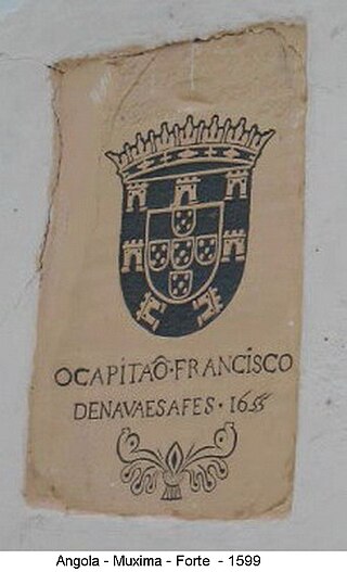
The Fortress of Muxima, built of stone and mortar in 1599, is situated in the Bengo Province of Angola next to the Cuanza River.

The Church of Our lady of Muxima is located in the Muxima District of Bengo Province, western Angola.
The Little Fort of Kikombo is located in the town of Kikombo on the Atlantic coast of Angola, where Rio Kikombo reaches the ocean, in the province of Kwanza-sul.
The Church of Nossa Senhora do Rosario is located in Kuanza Norte province, Angola.
Cambambe is a municipality in Cuanza Norte Province in Angola. It is the site of a hydroelectric dam on the Cuanza River. Cambambe also contains ruins from the 17th-century Portuguese settlement of the area, including the Church of Nossa Senhora do Rosario and the Fortress of Kambambe. The municipality had a population of 90,766 in 2014.

The Cambambe Hydroelectric Power Station is a hydroelectric power plant across the Kwanza River at the border between Cuanza Norte Province and Bengo Province in Angola. Following rehabilitation and expansion, the generation capacity of this installation is 960 megawatts (1,290,000 hp).
The Portuguese colony of Angola was founded in 1575 with the arrival of Paulo Dias de Novais with a hundred families of colonists and four hundred soldiers. Luanda was granted the status of city in 1605. The fortified Portuguese towns of Luanda and Benguela.
São Pedro da Quilemba is a town and commune of Angola, located in the province of Cuanza Norte.

The Fort Nossa Senhora da Vitória de Massangano, popularly known as Fortress of Massangano is located in the village-commune of Massangano, in the municipality of Cambambe, in the province of Cuanza-Norte, in Angola.
References
- ↑ Welch, Sidney R. (1950), Portuguese Rule and Spanish Crown in South Africa, 1581-1640, Cape Town: Juta.
- ↑ Fortress of Kambambe - UNESCO World Heritage Centre
- 1 2 Freudenthal,Aida. Fortress: Kambambe, Cambambe, Kwanza, Angola. October 11, 2012.