Fuerte San Miguel (Uruguay)

Last updated

Fuerte San Miguel Fuerte San Miguel 4.jpg
Fuerte San Miguel
Fuerte San Miguel Fuerte de San Miguel I.JPG
Fuerte San Miguel

Fuerte de San Miguel is a military fortification in the small town of Dieciocho de Julio in the Rocha Department of eastern Uruguay. It was erected in 1737 by the Portuguese, having abandoned the attempt at building a fort in Maldonado. [1] It was constructed of large, heavy stones to create the tall towers (four bastions), thick walls and sturdy ramparts to withstand the onslaught of wars fought against the Spanish invaders which was instrumental in Uruguay evolving as an independent nation. [2] [3]

Contents

Geography

The fort is located on Route 19, 6 kilometres (3.7 mi) south of the Laguna Merin, and 8 kilometres (5.0 mi) west of Chuy. Visible after passing Paso de Punta Segra, it is situated on top of the Sierra de San Miguel, thirty-five metres high, [4] in an area of mostly large and extensive valleys. At the foot of the mountain runs the San Miguel River, though it is out of sight of the fortress. In the distance are mountains forming the boundary with Brazil. [5]

History

With a garrison of 100 men, the fort was used by the Portuguese as an observation post of the movements of the Spanish forces. Article XVIII of the Treaty of Madrid (1750) decided that Portugal would keep the line of Castillos Grande, and could strengthen it. Before the signing of the Treaty of El Pardo (1761), the governor and captain-general of the captaincy of Rio de Janeiro, Gomes Freire de Andrade, anticipated the consequences for the South and ordered the governor of the Colony of Rio Grande de São Pedro, Colonel Elói Madureira, to immediately dispatch troops to the Laguna region. The Portuguese strategy was to quickly build a fortified defensive line, south of Fort San Miguel, to stop the Spanish invasion in progress, after the conquest of Colonia del Sacramento in October 1762 by Governor Pedro de Cevallos of Buenos Aires. [6]

Main gate of Fuerte San Miguel Fuerte San Miguel ..jpg
Main gate of Fuerte San Miguel

In October 1762, construction of the Fortaleza de Santa Teresa began nearby to surpass San Miguel as the main Portuguese stronghold. In April 1763, Ceballos took San Miguel and the Spanish improved it considerably into a fully functioning fort. [7] In 1775 engineer Bernardo Lecocq made reinforcement works to the structure of the fort, with a British invasion imminent. [8] With the Treaty of San Ildefonso (1777), [9] the Spanish were legally confirmed as being in possession of the fort. In 1797, the fort reached its peak as a stronghold when it was strengthened further, again in anticipation of war.

After Uruguayan independence in 1828, the fort was deactivated and abandoned, becoming a ruin over time. [10] By 1891, the fort was covered with plants, forming cracks; in one corner, a mountain palm (Cocos australis) was growing. [5]

Architecture

Initially designed as a simple defence base, building started on 17 October 1737 by the Portuguese [11] (although the monument itself implies it was built between 1734 and 1737), attributing its construction to the military engineer Brigadier José da Silva Pais and the Portuguese military architect Manuel Gomes Pereira, later replaced by Captain Antonio Teixeira Carvalho. The fort is of smaller proportions than the neighbouring Fortaleza de Santa Teresa, being of lesser quality and irregular finishing due to the lack of granite stones available.

The initial plan had the shape of a rectangular stone polygon with two pentagonal bastions on the shorter sides at the corners, separated by curtains, and topped by watchtowers. By 1740, the base had developed, featuring a star format with four bastions pentagonal vertices in Vauban style, [12] with internal walls and service buildings erected in irregular stonework. There was a chapel on the mound, and on one of its sides, there is a deep well. [5] The perimeter of the walls total 300 metres (980 ft). [4]

Grounds

Access to the fort was by a drawbridge over a flooded moat. In one of the slopes of the hill that is covered with living vegetation, there is a notable outpost; facing to the east, it includes a wall with a small window, but its appearance is natural, like a cave or animal shelter. [5]

Reconstruction

However, over the years after the independence of Uruguay, the fort's walls started crumbling as it remained untended. Uruguayans, proud of the historical heritage of the fort of more than 300 years for the founding of Uruguay as an independent nation, decided to get the hill top fort restored in 1927. [1] [3] The history and structure of the fort were thus rescued by a committee composed of Gen. Alfredo R. Campos, General Alfredo Baldomir and historian Horacio Arredondo, which began operating in 1927. [1] In 1933, the fort was rebuilt according to original plans, using the techniques of the time, restoring the premises of the Command House, the Parliament House, the chapel, kitchen and Troop Barracks. [10] The fort was declared a National Monument of Uruguay in 1937, thereafter to promote the recovery process.

As a protected area, the diverse natural ecosystems has also been retained where native wildlife of Monkeys, birds, capybaras and guazubira are seen in the forests and marshland. [1] [3] [13]

Features

Under the administration of the Army, the structure is permanently open to visitors, harbouring a Museum of Military History, which highlights the collection of historical uniforms of the garrison, and the sample of the historical evolution of Army uniforms. [1] A series of watercolors by artist Emilio Regalía are on display.

Near the fort is the inn, Hosteria Fortin de San Miguel, a 1945 building built in the Spanish colonial style with 20 rooms and a ballroom that can accommodate 150 people. [14]

Related Research Articles

<span class="mw-page-title-main">Colonia del Sacramento</span> Capital city in Colonia, Uruguay

Colonia del Sacramento is a city in southwestern Uruguay, by the Río de la Plata, facing Buenos Aires, Argentina. It is one of the oldest towns in Uruguay and the capital of the Colonia Department. It has a population of around 27,000.

<span class="mw-page-title-main">Castillo San Cristóbal (San Juan)</span> Fortress in San Juan, Puerto Rico

Castillo San Cristóbal is a fortress in San Juan, Puerto Rico. It was built by the Spanish to protect against land-based attacks on the city of San Juan. It is part of San Juan National Historic Site.

<span class="mw-page-title-main">Fort Santiago</span> 16th-century citadel in Manila, Philippines

Fort Santiago, built in 1571, is a citadel built by Spanish navigator and governor Miguel López de Legazpi for the newly established city of Manila in the Philippines. The defense fortress is located in Intramuros, the walled city of Manila.

<span class="mw-page-title-main">Fort San Pedro</span> Bastioned fort in Cebu, Philippines

Fort San Pedro is a military defense structure in Cebu, Philippines, built by the Spanish under the command of Miguel López de Legazpi, first governor of the Captaincy General of the Philippines. It is located in the area now called Plaza Independencia, in the pier area of the city. The original fort was made of wood and built after the arrival of Legazpi and his expedition. In the early 17th century a stone fort was built to repel Muslim raiders. Today's structure dates from 1738 and is the oldest triangular bastion fort in the country. It served as the nucleus of the first Spanish settlement in the Philippines. During the Philippine Revolution at the end of the 19th century, it was attacked and taken by Filipino revolutionaries, who used it as a stronghold.

Banda Oriental, or more fully Banda Oriental del Uruguay, was the name of the South American territories east of the Uruguay River and north of Río de la Plata that comprise the modern nation of Uruguay; the modern state of Rio Grande do Sul, Brazil; and some of the modern state of Santa Catarina, Brazil. It was the easternmost territory of the Viceroyalty of the Río de la Plata.

<span class="mw-page-title-main">Chuy</span> City in Rocha, Uruguay

Chuy is a city in the extreme east of Uruguay, in the Rocha Department, 340 kilometres (211 mi) northeast of Montevideo. It lies on the border with Brazil, separated from its Brazilian sister town of Chuí only by a shared avenue that serves as the border, and by the Arroyo Chuy (stream) to the east. Chuy's population was 9,675 in 2011.

<span class="mw-page-title-main">Ciudad Colonial (Santo Domingo)</span> Historic district in Distrito Nacional, Dominican Republic

Ciudad Colonial is the historic central neighborhood of the Dominican Republic's capital Santo Domingo. It is the oldest continuously inhabited European-established settlement in the Americas. The area has been declared a World Heritage Site by UNESCO. It is also known as Zona Colonial or more colloquially as "La Zona".

<span class="mw-page-title-main">Fortress of São João Baptista (Angra do Heroísmo)</span> Bastion forts in Portugal

The Fortress of São João Baptista, also known as the Fort of São Filipe or Fort of Monte Brasil is a historic fortress and defensive emplacement, located in the civil parish of Sé, municipality of Angra do Heroísmo in the Portuguese island of Terceira, archipelago of the Azores.

<span class="mw-page-title-main">Fortín Solano</span> 18th-century colonial castle in Venezuela

Fortín Solano is an eighteenth-century colonial fortification overlooking Puerto Cabello, Venezuela. With the Castillo San Felipe, an earlier fort built at sea level, it formed part of a complex of fortifications designed to protect Puerto Cabello and its important harbour from naval attacks. It was constructed c. 1766 by order of Don José Solano y Bote on behalf of the King of Spain. It has been described as the last military construction built in Venezuela during the colonial era.

Alfredo Miguel Aguayo Sánchez was a Puerto Rican educator and writer. He studied and lived in Cuba, and was a professor at the University of Havana. His teachings and his written works molded several generations of Cubans.

<span class="mw-page-title-main">Dieciocho de Julio</span> Town in Rocha Department, Uruguay

Dieciocho de Julio or 18 de Julio is a small town in the Rocha Department of southeastern Uruguay.

<span class="mw-page-title-main">Route 9 (Uruguay)</span> Road in Uruguay

Route 9 is a national route of Uruguay. In 1975, it was assigned the name Coronel Leonardo Olivera, a national hero of Uruguay. It connects Dr. Francisco Soca with Chuy in the northeast.

<span class="mw-page-title-main">Fortaleza de Santa Teresa</span> Military museum in Uruguay

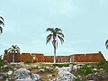
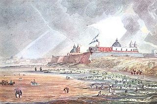
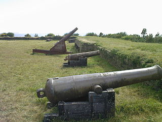
The Fortaleza de Santa Teresa, or Fortaleza Santa Tereza is a military fortification located 36 km (22 mi) south of Chuy and 305 km (190 mi) northeast of Montevideo on Route 9, in the Rocha Department of eastern Uruguay. It lies about 800 m (2,600 ft) from the coast at Playa la Moza, almost halfway between Angostura and La Coronilla , north of Punta del Diablo and roughly 4 km (2.5 mi) northeast of the northeast bank of the Laguna Negra. It lies within the Santa Teresa National Park. It was erected from October 1762 by the Portuguese, having abandoned the attempt at building a fort in Maldonado and leaving the Fuerte San Miguel.

La Esmeralda is a beach town and seaside locality in Uruguay, Rocha Department.

<span class="mw-page-title-main">Santa María de la Cabeza castle</span> Colonial castle in Cumaná, Venezuela

Santa María de la Cabeza castle is a colonial castle built in the seventeenth century by the Spanish monarchy in the center of the city of Cumaná, Venezuela. It was built as a replacement for the San Antonio de la Eminencia castle. Its construction was ordered by Sancho Fernando de Angulo y Sandoval, governor of the Province of Cumaná. The building was designed using the trace italienne style popular during the seventeenth century, with a proportional geometric floor design. Bastions were used as the main defensive elements. The castle housed a garrison of 250 soldiers, and was the seat of government for the Province of Cumaná.

The Fort of San Diego, formerly also known as the Fort of San Carlos is a star fort in Acapulco, Guerrero, Mexico. It was built by the Spanish Empire, and it was one of the most important Spanish fortifications along the Pacific coast. The fort was first built in the 17th century, but was completely rebuilt in the 18th century. Today, it is an important landmark in Acapulco, and it is open to the public as the Acapulco Historic Museum.
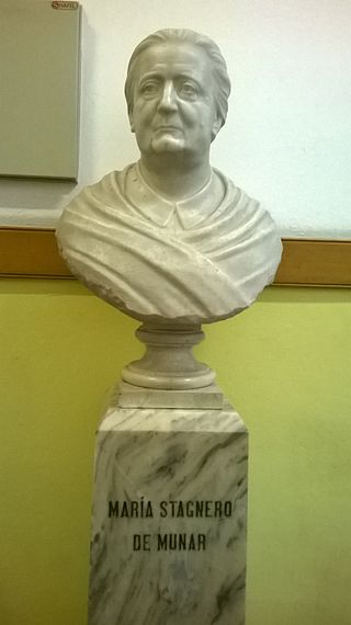
<span class="mw-page-title-main">Casa Fuerte de Adeje</span> Fortified building complex in Tenerife, Spain

Casa Fuerte de Adeje is a fortified building complex in Adeje, Tenerife, Spain. A strong house was constructed around 1556 to protect a sugar mill, and the site was subsequently significantly expanded. The building complex was renovated in the 1700s before a fire left it in ruins in 1902, a state in which it remains today, leading to its inclusion on the Spanish Redlist of endangered heritage in 2019. Since then some restoration work has taken place and part of the monument has been opened to the public for daily visits.

<span class="mw-page-title-main">City Wall of San Juan</span> Fortification in Puerto Rico

The City Wall of San Juan is a city wall that surrounds the western end of the Islet of San Juan, site of the historic Old San Juan district in San Juan, Puerto Rico. This defensive wall system was built between the 16th and 20th centuries to protect the city and the Bay of San Juan, a highly strategic point in the Caribbean. These walls, along with the defensive fortresses in Old San Juan, form part of the UNESCO World Heritage Site-designated San Juan National Historic Site as they are characteristic examples of the historic methods of construction used in military architecture which adapted European designs and techniques to the special conditions of the Caribbean port cities.

References

  1. 1 2 3 4 5 "Museo Militar Fuerte de San Miguel". Archived from the original on 29 June 2011. Retrieved 4 June 2011.
  2. Regis St Louis; Sandra Bao; Gregor Clark; Aimee Dowl (3 March 2010). Lonely Planet South America on a Shoestring . Lonely Planet. pp.  902–. ISBN   978-1-74104-923-7 . Retrieved 4 June 2011.
  3. 1 2 3 "Explore Uruguay History of the San Miguel Fort in Chuy Uruguay". Explore Uruguay. Retrieved 4 June 2011.
  4. 1 2 Castellanos, Alfredo Raúl (1974). Uruguay, monumentos históricos y arqueológicos. Instituto Panamericano de Georgrafía e Historia. p. 37. Retrieved 5 June 2011.
  5. 1 2 3 4 Araújo, Orestes (1900). Diccionario geografico del Uruguay (in Spanish) (Now in the public domain. ed.). Impr.artística, de Dornaleche y Reyes. pp.  692–693. Retrieved 5 June 2011.
  6. Rubio, Juan Ortega y (1908). Historia de España. Casa Editorial Bailly-Bailliere. p. 71. Retrieved 14 June 2011.
  7. Bruno, Cayetano (1974). Historia de la Iglesia en la Argentina. Editorial Don Bosco. p. 274. Retrieved 5 June 2011.
  8. Uruguay. Dirección de Enseñanza Primaria y Normal (1946). Anales de instrucción primaria. Departamento Técnico, Consejo Nacional de Enseñanza Primaria y Normal. p. 52. Retrieved 5 June 2011.
  9. Cantillo, Alejandro del (1843). Tratados, convenios y declaraciones de paz y de comercio que han hecho con las potencias estranjeras los monarcas españoles de la casa de Borbon: Desde el año de 1700 hasta el dia. Puestos en órden é ilustrados muchos de ellos con la historia de sus respectivas negociaciones Por Don Alejandro del Cantillo. Imprenta de Alegria y Charlain. p. 22. Retrieved 5 June 2011.
  10. 1 2 "FUERTE DE SAN MIGUEL". Ingeniero Militares. Archived from the original on 24 March 2012. Retrieved 5 May 2011.
  11. Robertson, William Spence (1938). IIo Congreso internacional de historia de América. Talleres de la s.a. Casa Jacobo Peuser, lda. p. 621. Retrieved 5 June 2011.
  12. El museo universal. 1859. p. 166. Retrieved 5 June 2011.
  13. Ben Box; Jane Egginton; Mick Day (31 December 2002). Brazil handbook . Footprint Travel Guides. pp.  358–. ISBN   978-1-903471-44-9 . Retrieved 4 June 2011.
  14. "Hotel Fortín de San Miguel". turismoenuruguay.com. Retrieved 5 June 2011.

33°41′22″S53°32′20″W / 33.689401°S 53.538848°W / -33.689401; -53.538848