
The geography of Mozambique consists mostly of coastal lowlands with uplands in its center and high plateaus in the northwest. There are also mountains in the western portion. The country is located on the east coast of southern Africa, directly west of the island of Madagascar. Mozambique has a tropical climate with two seasons, a wet season from October to March and a dry season from April to September.

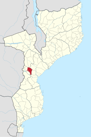
Manica is a province of Mozambique. It has an area of 62,272 km2 and a population of 1,945,994. The province is surrounded by Zimbabwe to the west, Tete Province to the northwest, Sofala Province to the east, the Save River to the south, and the Zambezi river to the northeast. Chimoio is the capital of the province. The highest mountain in Mozambique, Mount Binga, lies in this province near the border with Zimbabwe. The Manica province is divided into nine districts and 34 administrative regions.

Gaza is a province of Mozambique. It has an area of 75,709 km2 and a population of 1,422,460, which is the least populous of all the provinces of Mozambique.

Beira is the capital and largest city of Sofala Province, in the central region of Mozambique.

The Eastern Highlands, also known as the Manica Highlands, is a mountain range on the border of Zimbabwe and Mozambique. The Eastern Highlands extend north and south for about 300 kilometres (190 mi) through Zimbabwe's Manicaland Province and Mozambique's Manica Province.

Chimoio is the capital of Manica Province in Mozambique. It is the fifth-largest city in Mozambique.

Cuamba is a city and district of Niassa Province in Mozambique, lying north west of Mount Namuli. Before independence the town was known as Nova Freixo.
Articles related to Mozambique include:

Buzi River is a river in Mozambique. The Buzi originates in the Eastern Highlands on the border of Mozambique and Zimbabwe, and flows eastward through Manica and Sofala provinces of Mozambique. It empties to the Mozambique Channel west of Beira, forming a large estuary with the Pungwe River.
Gondola District is a district of Manica Province in western Mozambique. The principal town is Gondola. The area of the district is 5,739 square kilometres (2,216 sq mi). It has a population of 262,412 as of 2007.

Manica District is a district of Manica Province in western Mozambique. The principal town is Manica. The district is located in the west of the province, and borders with Báruè District in the north, Vanduzi District in the east, Sussundenga District in the south, and with Zimbabwe in the west. The area of the district is 4,594 square kilometres (1,774 sq mi). It has a population of 213,206 as of 2007.

Vila de Sena or more commonly Sena is a town in Mozambique where there is a fundamental bridge over the Zambezi River. This bridge, the Dona Ana Bridge was originally a single track railway bridge, temporarily converted to road operation during the civil war.
Railway stations in Mozambique include:
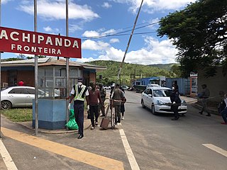
Machipanda is a town in Manica District, in the middle of Manica Province, Mozambique, near the border with Zimbabwe.

Beira-Bulawayo railway, also called Machipanda railway, Beira-Harare-Bulawayo railway and Beira railway, is a railway that connects the city of Beira, Mozambique, to the city of Bulawayo, in Zimbabwe. It is 850 km long, in a 1067 mm gauge.

Vanduzi District is a district in Manica Province of Mozambique.
The Chicamba Hydroelectric Power Station is an operational 44 megawatts (59,000 hp) hydroelectric power project in Mozambique. The power plant, first established in 1968, underwent rehabilitation and upgrades in 2017, raising its generating capacity, from 38.4 megawatts to 44 megawatts, with prolongation of its lifespan by another thirty years.
The Mavuzi Hydroelectric Power Station is an operational 41 megawatts (55,000 hp) hydroelectric power project in Mozambique. The power plant, first established in 1957, underwent upgrades and rehabilitation in 2017, adjusting its generating capacity, from 52 megawatts to 41 megawatts, with prolongation of its lifespan by another thirty years.

