You can help expand this article with text translated from the corresponding article in French. (December 2021)Click [show] for important translation instructions.
|
| Cuanza Kwanza, Quanza, Coanza | |
|---|---|
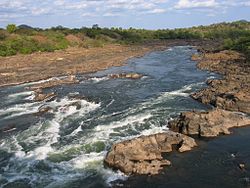 | |
 Cuanza River and tributaries | |
| Location | |
| Country | Angola |
| Physical characteristics | |
| Source | Bié Plateau [1] |
| • location | Central Angola |
| • elevation | 1,234 m (4,049 ft) |
| Mouth | Atlantic Ocean |
• location | 60 km (37 mi) south of Luanda |
• coordinates | 9°21′S13°9′E / 9.350°S 13.150°E |
| Length | 960 km (600 mi) [1] |
| Basin size | 152,570 km2 (58,910 sq mi) [2] |
| Discharge | |
| • location | Near mouth |
| • average | (Period: 1971–2000)1,944.3 m3/s (68,660 cu ft/s) [2] |
| Basin features | |
| River system | Cuanza River |
| Tributaries | |
| • left | Kukema, Cunhinga, Ngango, Cutato |
| • right | Cuiva, Luando, Cuige, Lucala |
| Waterbodies | Cambambe reservoir |
The Cuanza River, [3] also known as the Kwanza, [4] the Quanza, [4] or the Coanza, is the longest river in Angola. It empties into the Atlantic Ocean just south of the national capital Luanda.