Cunene River

Last updated
Cunene River
Kunene River
Reka Kunene River, vodopady Epupa Falls - Namibie, Angola - panoramio.jpg
Cunene (Kunene) River near Epupa Falls
Cunene-River-Angola.png
Course of the Kunene (Cunene) River, parts in Angola highlighted in blue
Location
Countries Angola and Namibia
Physical characteristics
Source 
  locationAngolan Highlands
Mouth Atlantic Ocean
  coordinates
17°15′09″S11°45′05″E / 17.25250°S 11.75139°E / -17.25250; 11.75139
  elevation
0 m (0 ft)
Length1,050 km (650 mi)
Basin size106,560 km2 (41,140 sq mi) to 108,943 km2 (42,063 sq mi) [1]
Discharge 
  average(Period: 1971–2000)221.7 m3/s (7,830 cu ft/s) [1] 174 m3/s (6,100 cu ft/s)
Basin features
Waterfalls Epupa Falls, Ruacana Falls
Epupa Falls Epupa Falls 3.jpg
Epupa Falls

The Cunene (Portuguese spelling) or Kunene (common Namibian spelling) [lower-alpha 1] is a river in Southern Africa. It flows from the Angola highlands southwards to the border with Namibia. It then flows in a westerly direction along the border until it reaches the Atlantic Ocean.

Contents

Geography

One of the few perennial rivers in the region, the Cunene is about 1,050 km (650 mi) long, with a drainage basin 106,560 km2 (41,140 sq mi) in area. Its mean annual discharge is 174 m3/s (6,100 cu ft/s) to 222 m3/s (7,800 cu ft/s) at its mouth. [5] [1] The Epupa Falls lie on the river. Olushandja Dam dams a tributary of the river, the Etaka, and helps to provide the Ruacana Power Station with water.

The main stream rises in 12° 30′ S. and about 160 miles in a direct line from the sea at Benguella, runs generally from north to south through four degrees of latitude, but finally flows west to the sea through a break in the outer highlands. [6]

Between the mouths of the two of its tributaries, the Cunene traverses a swampy plain, inundated during high water, and containing several small lakes at other parts of the year. From this swampy region divergent branches run S.E. They are mainly intermittent, but the Kwamatuo, which leaves the main stream in about 15° 8′ E., 17° 15′ S., flows into a large marsh or lake called Etosha, which occupies a depression in the inner table-land about 3400 ft. above sea-level. From the S.E. end of the Etosha lake streams issue in the direction of the Okavango, to which in times of great flood they contribute some water. [6]

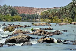
On leaving the swampy region the Cunene turns decidedly to the west, and descends to the coast plain by a number of cataracts, of which the chief (in 17° 25′ S., 14° 20′ E.) has a fall of 330 ft. The river becomes smaller in volume as it passes through an almost desert region with little or no vegetation. The stream is sometimes shallow and fordable, at others confined to a narrow rocky channel. Near the sea the Cunene traverses a region of sand-hills, its mouth being completely blocked at low water. The river enters the Atlantic in 17° 18′ S., 11° 40′ E. There are indications that a former branch of the river once entered a bay to the south. [6]

Dam controversies

The Namibian government proposed in the late 1990s to build the Epupa Dam, a controversial hydroelectric dam on the Cunene. In 2012 the Governments of Namibia and Angola announced plans to jointly build the Orokawe dam in the Baynes Mountains. According to the indigenous Himba who would have been most affected by the construction of the dam, the dam would threaten the local ecosystem and therefore the economic basis of the Himba. During February 2012, traditional Himba chiefs issued a declaration to the African Union and to the United Nations Human Rights Council of the United Nations, titled "Declaration of the most affected Ovahimba, Ovatwa, Ovatjimba and Ovazemba against the Orokawe Dam in the Baynes Mountains," which outlines the fierce objections against the dam from the traditional Himba chiefs and communities that reside near the Kunene River. [7] [8] [9]

In September 2012, the United Nations special rapporteur on the Rights of Indigenous Peoples visited the Himba, and heard their concerns.

On November 23, 2012, hundreds of Himba and Zemba from Omuhonga and Epupa region protested in Okanguati against Namibia's plans to construct a dam in the Kunene River in the Baynes Mountains, against increasing mining operations on their traditional land and human rights violations against them. [10]

On March 25, 2013, over a thousand Himba and Zemba people marched in Opuwo [11] to protest once more against Namibia's plans to build the Orokawe dam in the Cunene River without consulting with the indigenous peoples that do not consent to the construction plans. [12]

Attraction

Tourists frequent campsites or lodges at Epupa, which offer water sports on the river, including rafting and canoeing. [13] Ancient baobab trees grow alongside the gorge, and there is an attractive and well-kept viewpoint high above the village and falls.

Notes

Related Research Articles

<span class="mw-page-title-main">Himba people</span> Ethnic group of Namibia

The Himba are an indigenous people with an estimated population of about 50,000 people living in northern Namibia, in the Kunene Region and on the other side of the Kunene River in southern Angola. There are also a few groups left of the OvaTwa, who the OvaHimba consider to be part of their tribe, but are hunter-gatherers. Culturally distinguishable from the Herero people, the OvaHimba are a semi-nomadic, pastoralist people and speak OtjiHimba, a variety of Herero, which belongs to the Bantu family within Niger–Congo. The OvaHimba are semi-nomadic as they have base homesteads where crops are cultivated, but may have to move within the year depending on rainfall and where there is access to water.

<span class="mw-page-title-main">Omusati Region</span> Region in Namibia

Omusati is one of the fourteen regions of Namibia, its capital is Outapi. The towns of Okahao, Oshikuku and Ruacana as well as the self-governed village Tsandi are situated in this region. As of 2020, Omusati had 148,834 registered voters.

<span class="mw-page-title-main">Kunene Region</span> Region in Namibia

Kunene is one of the fourteen regions of Namibia. Its capital is Opuwo, its governor is Marius Sheya. The region's name comes from the Kunene River which forms the northern border with Angola. Besides the capital Opuwo, the region contains the municipality of Outjo, the town Khorixas and the self-governed village Kamanjab. Kunene is home to the Himba people, a subtribe of the Herero, as well as to Damara people and Nama people. As of 2020, Kunene had 58,548 registered voters.

<span class="mw-page-title-main">Kaokoland</span>

Kaokoland was an administrative unit and a bantustan in northern South West Africa. Established in 1980 during the apartheid era, it was intended to be a self-governing homeland of the Ovahimba, but an actual government was never established, and the territory was administered by the leaders of Hereroland. Like other homelands in South West Africa, the Kaokoland bantustan was abolished in May 1989, at the beginning of the transition of Namibia towards independence.

<span class="mw-page-title-main">Epupa Constituency</span> Electoral constituency in the Kunene region of north-western Namibia

Epupa Constituency is a constituency in the Kunene Region of Namibia. The constituency contains the Epupa Falls after which it is named, located on the Angolan-Namibian border. Its population in 2004 was 12,816. In 2020 it had 12,182 registered voters.

<span class="mw-page-title-main">Ruacana</span> Town in Omusati Region, Namibia

Ruacana is a town in the Omusati Region of northern Namibia and the district capital of the Ruacana electoral constituency. It is located on the border with Angola on the river Kunene. The town is known for the picturesque Ruacana Falls nearby, and for the Ruacana Power Station.

<span class="mw-page-title-main">Epupa Falls</span> Series of waterfalls in Namibia

Epupa Falls is a series of large waterfalls formed by the Cunene River on the border of Angola and Namibia, in the Kaokoland area of the Kunene Region. The river is about 0.5 kilometres (1,600 ft) wide in this area and drops in a series of waterfalls across a length of 1.5 kilometres (0.93 mi), with the greatest single drop being 37 metres (121 ft) in height. The settlement near the falls is also called Epupa.

Articles related to Namibia include:

<span class="mw-page-title-main">Ruacana Falls</span> Waterfall in Namibia

Ruacana Falls is a waterfall located in Ruacana, Omusati on the Kunene River in Northern Namibia. The waterfall is 120 meters (390 ft) high and 700 meters (2,300 ft) wide in full flood. It is among the largest waterfalls in Africa, both by volume and width.

<span class="mw-page-title-main">Calueque</span> Town in Kunene Province, Angola

Calueque is a town next to a dam and pumping station of the same name on the Kunene River in the Kunene Province of southern Angola. The water project is linked to Ruacana, 20 km (12 mi) away in Namibia, where the Ruacana Power Station is. This dam is one of the last landmarks along the Kunene River, prior to the Kunene becoming a border feature between Angola and Namibia. A 300 km (190 mi) pipeline and canal extends across the border into Namibia, supplying towns as far away as Oshakati in Ovamboland with water. The dam was completed in 1976. However, due to the onset of the Angolan civil war following independence, the full master plan for the scheme was not realised by the South African and Portuguese governments.

<span class="mw-page-title-main">Angelika Muharukua</span> Namibian politician

Angelika Kazetjindire Muharukua was a Namibian politician. An ethnic Herero from northwestern Namibia, Muharukua joined the South West Africa People's Organization (SWAPO) in 1979. She was a surprise choice by President Sam Nujoma for the 2nd National Assembly of Namibia in 1995 and remained in the National Assembly since. In May 2004, she was chosen to replace Marlene Mungunda as deputy minister of Women Affairs and Child Welfare, later renamed the Ministry of Gender Equality and Child Welfare.

The Calueque Dam, is an operational multipurpose dam across the Kunene River, in Kunene Province, in southwestern Angola. The dam stores water for the 347 MW (465,000 hp) Ruacana Hydroelectric Power Station, in neighboring Namibia. Its waters are also used for the irrigation of farmland, both in Angola and Namibia.

<span class="mw-page-title-main">Angolan mopane woodlands</span>

Angolan mopane woodlands are situated in southwestern Angola, extending into northern Namibia. This ecosystem surrounds Etosha Pan, which is considered a separate ecoregion. The mopane trees are the main type of vegetation.

The Ruacana Hydroelectric Power Station is a hydroelectric power plant near Ruacana in northwest Namibia, close to the Angolan border. Commissioned in 1978, it is by far the largest power station in Namibia. Its operator is NamPower, the Namibian national electric power utility company.

<span class="mw-page-title-main">Ruacana Constituency</span> Electoral constituency in the Omusati region of northern Namibia

Ruacana Constituency is an electoral constituency in the Omusati Region of Namibia on the border to Angola. It had 10,722 inhabitants in 2004 and 9,285 registered voters in 2020. Its district capital is the town of Ruacana.

<span class="mw-page-title-main">Swartbooisdrift</span> Settlement in Kunene Region, Namibia

Swartbooisdrift is a small settlement in the Kunene Region in the north of Namibia. It is situated on the banks of the Kunene River, at the Angolan border on the minor road D3700 and falls within the Epupa electoral constituency. Swartbooisdrift is populated by 150 - 300 semi-nomadic people of Himba and Herero descent, depending on the season.

The Zembapeople are a Bantu ethnic group residing in the border regions of Namibia and Angola. In Namibia, they are predominantly found in the Kunene region, most notably in the Opuwa area. They speak the Zemba language, also known as OtjiZemba or Dhimba. The Zemba are well-known for their distinctive hairstyles, intricate iron and copper jewelry, as well as traditional clothing that often incorporates animal hides. Additionally, they decorate themselves with a blend of ash, ochre paste, and rancid butter to enhance their appearance.

The HIZETJITWA Indigenous Peoples Organisation (HIPO) is a non-governmental organisation operating in Namibia and Angola dedicated to the improvement of the living conditions of indigenous people. HIZETJITWA is an acronym made up of the first letters of the names of the indigenous tribes that are the focus of the organisation: Himba people, Zemba people, Tjimba people and Twa people. These native, semi nomadic people live in the mountainous and semi deserted areas of North West Kunene in Namibia and Angola. Individuals belonging to the Herero people in northern Kunene and from the Omusati Region, are also members of HIPO. The executive director is Tjinezuma Kavari.

The Baynes Hydroelectric Power Station is a planned 600 megawatts (804,613 hp) hydroelectric power plant in northwest Namibia, at the border with Angola.

<i>Okujepisa omukazendu</i> Northwest Namibian "wife-sharing" tradition

Okujepisa omukazendu is the polyamorous sexual practice of hospitable "wife-sharing" among the nomadic OvaHimba and OvaZemba peoples of Namibia's Kunene and Omusati regions. According to the practice, a man welcomes a familiar male guest to his home by allowing the visitor to sleep in the man's bed and have sex with his wife for the night, while the man sleeps in another hut or outside. The woman has little agency in the arrangement. The opposite arrangement, whereby a woman chooses a female friend for her husband to have sex with, exists, but is rare. The practice has been described as "generations-old", "centuries-old", and "ancient". The practice's justifications include belief that it deepens friendship and prevents promiscuity and jealousy in both sexes.

References

  1. 1 2 3 "South West Coast".
  2. "Cunene". The American Heritage Dictionary of the English Language (5th ed.). HarperCollins. Retrieved May 30, 2019.
  3. "Cunene" (US) and "Cunene". Lexico UK English Dictionary. Oxford University Press. Archived from the original on 2020-03-22.
  4. "Cunene". Merriam-Webster.com Dictionary . Retrieved May 30, 2019.
  5. Nakayama 2003, p. 9.
  6. 1 2 3 Wikisource-logo.svg One or more of the preceding sentences incorporates text from a publication now in the public domain :  Chisholm, Hugh, ed. (1911). "Kunene". Encyclopædia Britannica . Vol. 15 (11th ed.). Cambridge University Press. p. 946–947.
  7. "Indigenous Himba Appeal to UN to Fight Namibian Dam". galdu.org. Archived from the original on October 17, 2013. Retrieved April 6, 2012.
  8. "Namibian Minority Groups Demand Their Rights". newsodrome.com. Archived from the original on October 17, 2013. Retrieved April 6, 2012.
  9. "Declaration of the most affected Ovahimba, Ovatwa, Ovatjimba and Ovazemba against the Orokawe Dam in the Baynes Mountains". earthpeoples.org. Retrieved April 6, 2012.
  10. "Namibia: Indigenous semi-nomadic Himba and Zemba march in protest against dam, mining and human rights violations". earthpeoples.org. Archived from the original on March 10, 2013. Retrieved November 24, 2012.
  11. "German GIZ directly engaged with dispossessing indigenous peoples of their lands and territories in Namibia". earthpeoples.org. Retrieved March 30, 2013.
  12. "Himba, Zemba reiterate 'no' to Baynes dam". Catherine Sasman for The Namibian. Archived from the original on March 29, 2013. Retrieved March 26, 2013.
  13. "KaokoHimba Safaris Namibia - Kaokoland, Epupa Falls Campsite, Himba People, Tours - Epupa Falls". Archived from the original on April 22, 2013. Retrieved March 23, 2013.

Sources