Cabinda is an exclave and province of Angola, a status that has been disputed by several political organizations in the territory. The capital city is also called Cabinda, known locally as Tchiowa, Tsiowa or Kiowa. The province is divided into four municipalities—Belize, Buco-Zau, Cabinda and Cacongo.
Shuqrah, also Shaqrāʾ or Shuqrāʾ, is a coastal town in southern Yemen. It was the capital of the Fadhli Sultanate until the capital moved to Zinjibar in 1962, although the royal residence remained in Shuqrah.

Kakongo was a small kingdom located on the Atlantic coast of Central Africa, in the modern-day Republic of the Congo and Cabinda Province, Angola. In the 13th century, it formed part of a confederation led by Vungu. Along with its neighboring kingdoms of Ngoyo and Loango, Kakongo became an important political commercial center during the 17th through 19th centuries. The people speak a dialect of the Kikongo language and thus may be considered a part of the Bakongo ethnicity. Kakongo was a vassal of the Kingdom of Kongo for a part of its history.
Chund Bharwana is a town of Jhang District in Punjab Province of Pakistan. It lies at the intersection of two main highways, the Jhang–Lalian road and Jhang–Sargodha road. Chund Bharwana is situated between two rivers, the Jhehlum and the Chenab. People intending to visit towns like Shahjewan, Marri Gujjraan, Pir Kot, Salyana, Chela, Jhagar, Haveli Sheikh Rajoo, Kala Baali, and Lalian, Pind Hassan khan pass through Chund Bharwana.
Al Abraq is a town in Libya, in the Derna District. It is located 23 km east of Bayda, Other names include the transliterations Al Labrag, Al Labraq, Al Lazraq, and El-Abràgh, as well as the Italian Luigi di Savoia. According to the census of 2006, the city had a population of 8,861 people.
Lal (La'l) sometimes called Lal wa Sarjangal is a town and the administrative center of Lal wa Sarjangal District, Ghor province in central Afghanistan.

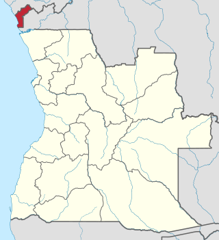
Cacongo is a municipality in Cabinda Province, an exclave of Angola. Its principal town is Cacongo. Landana lies on the coast of the Atlantic Ocean, adjacent to Landana Bay. The municipality covers 1,679 square kilometres (648 sq mi) and had a population of 39,076 at the 2014 Census; the latest official estimate is 44,974.

Naitaba Island is an island of the northern Lau Islands of Fiji. It is a triangular shaped island approximately 2.4 km (1.5 mi) in diameter. The island is volcanic with coral and rises to 186 metres (610 ft) on a flat-topped hill toward the southern end of the island. The island is forested and coconuts were grown commercially for copra. There is a barrier reef completely surrounding the island.
Cacongo is a town, with a population of 15,000 (2014), in Cacongo municipality, Cabinda Province, in Angola. The former Lândana municipality is now known as Cacongo, and the town is sometimes still known as Lândana. It is located on Lândana Bay about a kilometer south of the mouth of the Chiloango River.
The Palena River or Carrenleufú is a river shared by Chile and Argentina in Northern Patagonia. It drains the waters of the Vintter Lake, also shared by these nations, and it flows into the Pacific Ocean. 56.5% of the river basin lies in Chile.
Karabiga (Karabuga) is a town (belde) in the Biga District, Çanakkale Province, Turkey. Its population is 2,962 (2021). It is located at the mouth of the Biga River, on a small east-facing bay, known as Karabiga Bay. Its ancient name was Priapus or Priapos.
Yenga is a village in Nana-Mambéré, Central African Republic. It is 18 kilometres (11.2 mi) from Bouar and on the main road (RN3) between Bouar and Garoua-Boulaï in the Cameroon.
Hamāyūn is a village in Kapisa Province of Afghanistan. Hamayun lies on the eastern slope of Mt. Nēshar.
Lumë is a village in the former Shtiqën Municipality, Kukës County, Albania. At the 2015 local government reform it became part of the municipality Kukës.
The Simiyu River is a river located in Simiyu Region and Arusha Region, Tanzania. It flows into Lake Victoria in the African Great Lakes region. As one of the six main inlets to Lake Victoria, it forms part of the upper headwaters of the Nile. The Simiyu Region is named after the river.
Makary is a town in Logone-et-Chari, Far North Region, Cameroon, West Africa. The town is located on the right (east) bank of a distributary of the Chari River in the delta just before it enters Lake Chad. The people are known as Kotoko, and the local language is Mpade, Fulani (Fulfulde) is the trade language. The primary economic activity was and is fishing.
Shinga Deuxième is a village in Sankuru province of the Democratic Republic of the Congo. It lies at an elevation of 611 meters along highway A807 fifty kilometers by road northwest of the town of Katako-Kombe, and just east of the Tshuapa River.
Mandume (Dumbo) is a village in Bié Province, Angola, in southwestern Africa. It sits at an elevation of 1,481 metres (4,859 ft) in a seasonally swampy area on a tributary of the Cuelei River.
The Cuelei River (Kwelei) is a river in central Angola of southwestern Africa. For part of its length, it forms the border between Bié Province to the north and Cuando Cubango Province to the south. Its major tributary the Cuceque, and its tributary the Missango, also form part of that boundary.

The Pajarito Mountains are a small mountain range in the Sierra Madre Occidental. They are located in the state of Sonora in northwestern Mexico.


