
The Congo River, formerly also known as the Zaire River, is the second-longest river in Africa, shorter only than the Nile, as well as the third-largest river in the world by discharge volume, following the Amazon and Ganges rivers. It is the world's deepest recorded river, with measured depths of around 220 m (720 ft). The Congo–Lualaba–Luvua–Luapula–Chambeshi River system has an overall length of 4,700 km (2,900 mi), which makes it the world's ninth-longest river. The Chambeshi is a tributary of the Lualaba River, and Lualaba is the name of the Congo River upstream of Boyoma Falls, extending for 1,800 km (1,100 mi).
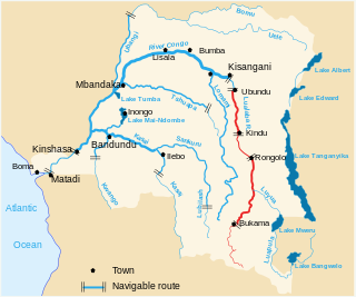
The Lualaba River flows entirely within the eastern part of Democratic Republic of the Congo. It provides the greatest streamflow to the Congo River, while the source of the Congo is recognized as the Chambeshi. The Lualaba is 1,800 kilometres (1,100 mi) long. Its headwaters are in the country's far southeastern corner near Musofi and Lubumbashi in Katanga Province, next to the Zambian Copperbelt.

The Luvua River is a river in the Katanga Province of the Democratic Republic of the Congo (DRC). It flows from the northern end of Lake Mweru on the Zambia-Congo border in a northwesterly direction for 350 kilometres (220 mi) to its confluence with the Lualaba River opposite the town of Ankoro. The Lualaba becomes the Congo River below the Boyoma Falls.

Kolwezi or Kolwesi is the capital city of Lualaba Province in the south of the Democratic Republic of the Congo, west of Likasi. It has an airport and a railway to Lubumbashi. Just outside of Kolwezi there is the static inverter plant of the HVDC Inga-Shaba. The population is approximately 573,000.
Haut-Katanga is one of the 21 new provinces of the Democratic Republic of the Congo created in the 2015 repartitioning. Haut-Katanga, Haut-Lomami, Lualaba, and Tanganyika provinces are the result of the dismemberment of the former Katanga province. Haut-Katanga was formed from the Haut-Katanga district and the independently administered cities of Likasi and Lubumbashi. Lubumbashi retained its status as a provincial capital. The estimated population was 5,718,800 in 2020.
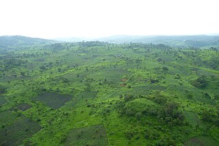
The Katanga or Shaba plateau is a farming and ranching region in the Democratic Republic of the Congo. Located in the southeastern Katanga Province, it is bordered by the Kundelungu and Mitumba mountain ranges from the north, Muchinga mountain range from the east, and connected to the Lunda Plateau in the south and west. it is 1220 m above sea level and is rich in copper and uranium deposits. The altitude makes it cooler than the surrounding area, with a mean annual temperature of 19-20 °C. The existence of seasonal rainfall makes Katanga Plateau a fertile arable area as well as an industrial region in DR Congo.
Articles related to the Democratic Republic of the Congo include:

Rail transport is provided in the Democratic Republic of the Congo by the Société Nationale des Chemins de Fer du Congo (SNCC), the Société commerciale des transports et des ports (SCTP) (previously Office National des Transports until 2011), and the Office des Chemins de fer des Ueles (CFU).
Lake Tshangalele, also known as Lake Lufira or Mwadingusha Reservoir, is an artificial lake in the south-east of the Democratic Republic of Congo. It is located about 20 km east of the city of Likasi in the old province of Katanga. It lies at about 1,100 m above sea-level in a large depression surrounded by low mountains. It was created by a dam built on the Lufira River near Mwadingusha in 1926 to provide hydro-electric power. The area of open water is about 362.5 km2. During the wettest months of February and March, the area flooded reaches a maximum of 440 km2. The lake is shallow with a mean depth of only 2.6 m.

Ctenopoma multispine, known as the many-spined ctenopoma or climbing perch, is an African freshwater fish. It is up to 14 cm (5.5 in) long and occurs in the Lufira River, Lualaba River, Upemba River, Luapula-Moero in the Democratic Republic of the Congo, Upper Zambezi in Zambia and Okavango River-Lake Ngami in Angola and Botswana. It is also known from the Kafue, rivers of coastal Mozambique, Cuanza River in Angola, and southern tributaries of the Congo River system.

Cyphomyrus is a genus of ray-finned fish in the family Mormyridae, the freshwater elephantfishes.

Haut-Katanga District is a former district located in the former Katanga Province of the Democratic Republic of the Congo. The copper mining centers of Lubumbashi and Likasi were surrounded by the district but were administratively separate.
Mwadingusha is a community in the Kambove Territory of Haut Katanga District in the Democratic Republic of the Congo.

Tilapia sparrmanii, the banded tilapia, or vlei kurper, is a widespread and adaptable cichlid fish that is found in warmer freshwater habitats of southern Africa. They prefer water with ample plant cover, and occur naturally as far north as DR Congo and Tanzania. They have been introduced locally in the northern hemisphere. Younger banded tilapia feed on crustaceans and insect larvae, while the adults feed on terrestrial and aquatic plants and other debris. They undertake local migrations and may shoal before and during spawning time. They guard their own eggs, and although they may move eggs or fry in the mouth, they are not known to be actual mouthbrooders like several other tilapia species. This species can reach a length of 23.5 centimetres (9.3 in) TL and is an important foodfish.
Haut-Luapula District was a district of the Belgian Congo from 1912 to 1933, when it was dissolved. It roughly corresponded to the southern part of the present Haut-Katanga Province.
Luapula-Moero District was a district of the pre-2015 Katanga Province in the Belgian Congo and Democratic Republic of the Congo. It roughly corresponded in area to the present Haut-Katanga Province.
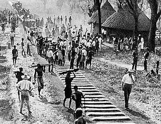
The Compagnie de Chemin de fer du Katanga (CFK) was a railway company in the Congo Free State and Belgian Congo between 1902 and 1952. It held the railway concession that linked the port of Bukama on the navigable section of the Lualaba River through the mining region and the town of Elisabethville (Lubumbashi) to Sakania, where it connected with the Rhodesian railway network. Operations were subcontracted to the Compagnie du chemin de fer du bas-Congo au Katanga (BCK).

Kamatanda is a region just north of Likasi in the Haut-Katanga Province of the Democratic Republic of the Congo. It gives its name to an open-pit copper mine, a railway junction, an abandoned airport and a residential area of Likasi.
The Mwadingusha Hydroelectric Power Station, also Mwadingusha Power Station is a 78.3 megawatts hydroelectric power station across the Lufira River in the Democratic Republic of the Congo. Originally commercially commissioned in 1930, the six electricity generators were replaced and upgraded from 11.8 MW each, to 13.05 MW each, raising generation capacity from 71 MW to 78.3 MW.

