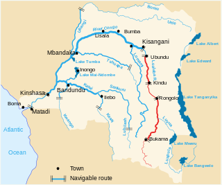
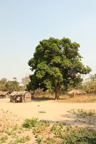
The Lualaba River flows entirely within the eastern part of Democratic Republic of the Congo. It provides the greatest streamflow to the Congo River, while the source of the Congo is recognized as the Chambeshi. The Lualaba is 1,800 kilometres (1,100 mi) long. Its headwaters are in the country's far southeastern corner near Musofi and Lubumbashi in Katanga Province, next to the Zambian Copperbelt.
The Kwilu River is a major river in Kwilu Province, formerly known as Bandundu province, in the Democratic Republic of the Congo (DRC) to the city of Bandundu, where it joins the Kwango River just before this stream enters the Kasai River. In the DRC the river flows past the towns of Gungu, Kikwit, Bulungu, Bagata, Rutherfordia and Bandundu. Lusanga, formerly Leverville, lies at the location where the Kwenge River joins the Kwilu, between Kikwit and Bulungu.

Kolwezi or Kolwesi is the capital city of Lualaba Province in the south of the Democratic Republic of the Congo, west of Likasi. It is home to an airport and a railway to Lubumbashi. Just outside of Kolwezi there is the static inverter plant of the HVDC Inga-Shaba. The population is approximately 573,000.
The Lufira River is a tributary of the Lualaba River in the Democratic Republic of the Congo (DRC).

The Lukuga River is a tributary of the Lualaba River in the Democratic Republic of the Congo (DRC) that drains Lake Tanganyika. It is unusual in that its flow varies not just seasonally but also due to longer term climate fluctuations.
The Ulindi River is a tributary of the Lualaba River in the Democratic Republic of the Congo (DRC). There is a proposal to build a hydroelectric power plant on the river to power a gold mining project.

Rail transport is provided in the Democratic Republic of the Congo by the Société Nationale des Chemins de Fer du Congo (SNCC), the Société commerciale des transports et des ports (SCTP) (previously Office National des Transports until 2011), and the Office des Chemins de fer des Ueles (CFU).
Lake Tshangalele, also known as Lake Lufira or Mwadingusha Reservoir, is an artificial lake in the south-east of the Democratic Republic of Congo. It is located about 20 km east of the city of Likasi in the old province of Katanga. It lies at about 1,100 m above sea-level in a large depression surrounded by low mountains. It was created by a dam built on the Lufira River near Mwadingusha in 1926 to provide hydro-electric power. The area of open water is about 362.5 km2. During the wettest months of February and March, the area flooded reaches a maximum of 440 km2. The lake is shallow with a mean depth of only 2.6 m.

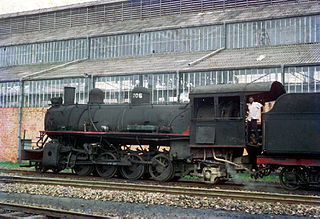
The Société Nationale des Chemins de Fer Zaïrois (SNCZ) was the state railway company in Zaire formed in 1974 by combining several privately owned railways. It suffered from lack of maintenance of the tracks and rolling stock, weak management, and external factors such as the Angolan Civil War and the collapse of the economy of Zaire under President Mobutu Sese Seko. Despite two projects funded by the World Bank, it had virtually ceased to function by the 1990s. It was replaced in 1995 by the short-lived private company SIZARAIL, which in turn was replaced by the present Société nationale des chemins de fer du Congo.
The Paulo Afonso Hydroelectric Complex, also known as the Paulo Afonso Complex, is a system of three dams and five hydroelectric power plants on the São Francisco River near the city of Paulo Afonso in Bahia, Brazil. The complex exploits an 80-metre (260 ft) natural gap on the river, known as the Paulo Afonso Falls. Constructed in succession between 1948 and 1979, the dams support the Paulo Afonso I, II, III, IV and Apollonius Sales (Moxotó) power plants which contain a total of 23 generators with an installed capacity of 4,279.6 megawatts (5,739,000 hp).

Pweto Territory is a territory in the Haut-Katanga Province of the Democratic Republic of the Congo (DRC). The headquarters are in the town of Pweto.

Équateur District was a former district of the Congo Free State, Belgian Congo and Democratic Republic of the Congo. In 1914 it became part of former Équateur Province. The district went through various changes of extent and name over the years. The original district roughly corresponds to the current provinces of Équateur and Tshuapa.
The Lukushi River is a tributary of the Luvua River. It runs from south to north through the Malemba-Nkulu Territory of Haut-Lomami Province and the Manono Territory of Tanganyika Province, passing the twin tin-mining towns of Kitotolo and Manono shortly before entering the Luvua.

The Rutshuru River is a river in the eastern Democratic Republic of the Congo that drains Lake Mutanda in the foothills of the Virunga Mountains in Uganda, flowing northward into Lake Rutanzige. For most of its length it runs through the Rutshuru Territory in North Kivu province.
The Kiymbi Dam is a major hydroelectric dam and power station that was opened on the Kiymbi river in 1959. It has been neglected and requires rehabilitation.

The Districts of the Belgian Congo were the primary administrative divisions when Belgium annexed the Congo Free State in 1908, each administered by a district commissioner. In 1914 they were distributed among four large provinces, with some boundary changes. In 1933 the provinces were restructured into six, again with boundary changes. The number of districts fluctuated between 12 and 26 through splits and consolidations, first rising, then falling, then rising again.
The Compagnie du chemin de fer du bas-Congo au Katanga (BCK) was a railway operator in the Congo Free State, Belgian Congo and later in the Democratic Republic of the Congo and Zaire. Most of the lines were in the southern Katanga Province, with links to the Kasai River for transport of mineral exports down to Kinshasa and onward to the port of Matadi, and a link to the Angolan railway network for transport to Lobito on the Atlantic.

Tanganyika Concessions Limited was a British mining and railway company founded by the Scottish engineer and entrepreneur Robert Williams in 1899. The purpose was to exploit minerals in Northern Rhodesia and in the Congo Free State. Partly-owned subsidiaries included the Union Minière du Haut-Katanga (UMHK), which undertook mining in the Katanga portion of the copperbelt, and the Benguela railway, which provided a rail link across Angola to the Atlantic Ocean. Belgian banks eventually took over control of the company. The Angolan railway concession was returned to the state of Angola in 2001.
Géomines was a Belgian mining company active in the Belgian Congo and then in the Democratic Republic of the Congo. It was established in 1910, and exploited a large deposit in the southeast of the country to become one of the largest tin producers in the world. It was taken over by Zairetain in 1968.

