Lukuga River

Last updated
Lukuga River
River Lukuga, Kalemia.jpg
River Lukuga from the bridge in Kalemie
Lukuga river.jpg
The Lukuga River, in dark blue
Location
Country Democratic Republic of the Congo
Physical characteristics
Source 
  location Kalemie
  elevation2,800 ft (850 m) [1]
Mouth  
  location
Lualaba River
Length320 km (200 mi)
Basin size244,500 km2 (94,400 sq mi) [2]

The Lukuga River is a tributary of the Lualaba River in the Democratic Republic of the Congo (DRC) that drains Lake Tanganyika. It is unusual in that its flow varies not just seasonally but also due to longer term climate fluctuations.

Contents

Location

The Lukuga runs along the northern edge of the Katanga Plateau.[ citation needed ] The river leaves Lake Tanganyika at Kalemie and flows through a gap in the highlands westward through Tanganyika Province to join the Lualaba between Kabalo and Kongolo. [3] Typically the river accounts for 18% of water loss from the lake, with the rest being due to evaporation. [4] The Lukuga is heavily mineralized. [2] The proportions of ionic contents where the Lukuga River leaves the lake, with magnesium and potassium more prevalent than calcium and sodium, are caused by the Albertine Rift's hydrothermal inputs, as seen also at the outlets of Lake Kivu and Lake Edward. [5]

It seems likely that the present hydrological system was established quite recently when the still-active Virunga volcanoes erupted and blocked the northward flow of water from Lake Kivu into Lake Edward, causing it instead to discharge southward into Lake Tanganyika through the Ruzizi River. Before that, Lake Tanganyika, or separate sub-basins in what is now the lake, may have had no outlet other than evaporation. [6]

The Lukuga is of considerable interest to hydrologists, since the volume of water it carries from the lake varies considerably from time to time. [7] The river flow is greatest in May and least in November, corresponding to seasonal fluctuations in the lake level. [8] The river is highly sensitive to longer-term climate variations, such as the Neolithic Subpluvial around 4000 BC. [9] Since 1965 the outflow has tended to increase, although the total outflow of the Congo has been declining. [8]

The Lukuga has formed relatively recently, providing a route through which aquatic species of the Congo Basin could colonize Lake Tanganyika. [10] The river is home to hippopotamus and crocodiles. [11] There are low-grade coal deposits along the river's tributaries north of Kalemie and Moluba. [12]

Early years

The Lukuga in the north, Lake Tanganyika, the Luvua River to the south and the Lualaba form a territory that was once occupied by the Hemba people in the western part and the Tumbwe people in the more mountainous east. Kasangas of the Tumbwe lineage ruled various small states in this region. [13] The lower Lukuga and the Lualaba were natural lines of communication, and the river valleys were densely populated. [14] Around 1800, in the second half of the rule of the Luba Emperor Ilunga Sungu, Luba forces launched raids over the Lualaba that at one point reached as far as Kalemie. Some of the Luba settled in the region, and the people around Kalemie were subject to the Luba in the following reigns of Kumwimbe Ngombe and Ilunga Kabale. [13]

The Luba evolved the concept of the "fire king" to rule the peripheral areas of their empire such as the Luvua-Lukuga corridor, with the local ruler being a near-equal of the Luba emperor, sending only occasional tributes. The bamdudye and bakasandji secret societies were introduced into the area, providing genesis myths that helped legitimize the fire kings' position. These myths had been adopted and adapted by the Holoholo people of Kalemie by the late nineteenth century. [15] The Hemba state of Kyombo Mkubwa became the main client state of the Luba Empire. [16] However, by the time Europeans started to penetrate the region, Msiri's son Simbi, advancing from the south and forming alliances with the Hemba rulers against incursions from Tippu Tip, had detached Kyombo Mkubwa from the Luba heartland. [17]

European contacts

The black line indicates Stanley's route. Stanley's Lake Tanganyika.jpg
The black line indicates Stanley's route.

Around 1871 David Livingstone noticed the break in the hills through which the "Logumba" passed, and suggested that the river might be an outlet of Lake Tanganyika, and that there could be other outlets further north. [18] Verney Lovett Cameron reached the river at the point where it left the lake in May 1874 on his journey across Africa from east to west. He confirmed that it was the only outlet of Lake Tanganyika, but was unable to get a guide to accompany him down the river to verify that it flowed into the Lualaba. [19] In 1876 Henry Morton Stanley visited the lake. When he arrived, the lake level was low and he described the Lukuga as no more than a large creek extending westward for a great distance. However, he agreed that as the lake level rose the Lukuga would act as an outlet. [20] It seems that a sandbar had formed across the river mouth, and the river had silted behind the bar. [6]

In 1879 Joseph Thomson came to Kasenge from Pambete, travelling through very rough country. He found that the Lukuga creek was a large and fast-flowing river. He followed the course of the river for a few days, but hostile inhabitants of the region blocked his further explorations. [21] When Hermann von Wissmann reached the river in 1882 he found that the river had become a fast and wide effluent. He also noted that the lake level was 4.8 m (16 ft) below the highest watermark. [6]

Today

As of 2008, the Lukuga was highly polluted at the point where it entered the Lualaba. [22] In December 2010 the well-known South African kayaker and explorer Hendrik Coetzee was dragged out of his kayak on the Lukuga and killed by a crocodile. [11]

Related Research Articles

<span class="mw-page-title-main">Lake Mweru</span> Lake in Zambia

Lake Mweru is a freshwater lake on the longest arm of Africa's second-longest river, the Congo. Located on the border between Zambia and Democratic Republic of the Congo, it makes up 110 kilometres (68 mi) of the total length of the Congo, lying between its Luapula River (upstream) and Luvua River (downstream) segments.

<span class="mw-page-title-main">Lualaba River</span> River in Democratic Republic of the Congo

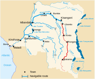
The Lualaba River flows entirely within the eastern part of Democratic Republic of the Congo. It provides the greatest streamflow to the Congo River, while the source of the Congo is recognized as the Chambeshi. The Lualaba is 1,800 kilometres (1,100 mi) long. Its headwaters are in the country's far southeastern corner near Musofi and Lubumbashi in Katanga Province, next to the Zambian Copperbelt.

<span class="mw-page-title-main">Luvua River</span> River in Katanga Province, Democratic Republic of the Congo

The Luvua River is a river in the Katanga Province of the Democratic Republic of the Congo (DRC). It flows from the northern end of Lake Mweru on the Zambia-Congo border in a northwesterly direction for 350 kilometres (220 mi) to its confluence with the Lualaba River opposite the town of Ankoro. The Lualaba becomes the Congo River below the Boyoma Falls.

<span class="mw-page-title-main">Ruzizi River</span> River in Central Africa

The Ruzizi is a river, 117 kilometres (73 mi) long, that flows from Lake Kivu to Lake Tanganyika in Central Africa, descending from about 1,500 metres (4,900 ft) to about 770 metres (2,530 ft) above sea level over its length. The steepest gradients occur over the first 40 kilometres (25 mi), where hydroelectric dams have been built. Further downstream, the Ruzizi Plain, the floor of the Western Rift Valley, has gentle hills, and the river flows into Lake Tanganyika through a delta, with one or two small channels splitting off from the main channel.

<span class="mw-page-title-main">Lubudi River (Lualaba tributary)</span> River in Democratic Republic of the Congo

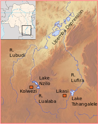
The Lubudi River is a tributary of the Lualaba River in the Democratic Republic of the Congo (DRC). The Lubudi rises near the Zambian border southwest of Kolwezi. It flows north and northeast to join the Lualaba from the left where the southern Katanga plateau drops into the Upemba Depression, near Bukama.

<span class="mw-page-title-main">Luama River</span> River in Democratic Republic of the Congo

The Luama River is a tributary of the Lualaba River in the Democratic Republic of the Congo (DRC).

Kalemie, formerly Albertville or Albertstad, is a city on the western shore of Lake Tanganyika in the Democratic Republic of the Congo. The Lukuga River, that drains Lake Tanganyika to the Lualaba River, runs through the city. Kalemie is the capital of Tanganyika Province.

<span class="mw-page-title-main">Kazembe</span>

Kazembe is a traditional kingdom in modern-day Zambia, and southeastern Congo. For more than 250 years, Kazembe has been an influential kingdom of the Kiluba-Chibemba, speaking the language of the Eastern Luba-Lunda people of south-central Africa. Its position on trade routes in a well-watered, relatively fertile and well-populated area of forestry, fishery and agricultural resources drew expeditions by traders and explorers who called it variously Kasembe, Cazembe and Casembe.

<span class="mw-page-title-main">Albertine Rift</span> Western branch of the East African Rift

The Albertine Rift is the western branch of the East African Rift, covering parts of Uganda, the Democratic Republic of the Congo (DRC), Rwanda, Burundi and Tanzania. It extends from the northern end of Lake Albert to the southern end of Lake Tanganyika. The geographical term includes the valley and the surrounding mountains.

Ilunga Mbidi was a soldier and cultural hero of the Luba and Lunda people.

<span class="mw-page-title-main">Kingdom of Luba</span> Pre-colonial (1585–1889) Central African

The Kingdom of Luba or Luba Empire (1585–1889) was a pre-colonial Central African state that arose in the marshy grasslands of the Upemba Depression in what is now southern Democratic Republic of Congo.

<span class="mw-page-title-main">Holoholo people</span> Ethnic group from Kigoma Region, Tanzania

The Holoholo also known as Kalanga are a Bantu ethnic group that inhabit the shores of central lake Tanganyika. The majority of them live near Kalemie city on Lake Tanganyika in Tanganyika Province of the Democratic Republic of the Congo, and on the opposite shore of the lake in Uvinza District of Kigoma Region in Tanzania.

Katende, or Sungu-Katende, was a royal sacred village of the Kingdom of Luba. It was adjacent to the village of Kabondo. Katende is on the upper Lomami in the Lualaba region in the Democratic Republic of the Congo.

Ilunga Sungu was a ruler (Mulopwe) of the Kingdom of Luba in what is now the Katanga Province of the Democratic Republic of the Congo, said to have reigned from about 1780 to his death.

The Hemba people are a Bantu ethnic group in the Democratic Republic of the Congo (DRC).

<span class="mw-page-title-main">Lukushi River</span> River in the Democratic Republic of the Congo

The Lukushi River is a tributary of the Luvua River. It runs from south to north through the Malemba-Nkulu Territory of Haut-Lomami Province and the Manono Territory of Tanganyika Province, passing the twin tin-mining towns of Kitotolo and Manono shortly before entering the Luvua.

The Tumbwe people are a Bantu ethnic group living mostly in Tanganyika District of the Democratic Republic of the Congo.

The Sanga people are an ethnic group that lives mostly in the Katanga Province of the Democratic Republic of the Congo.
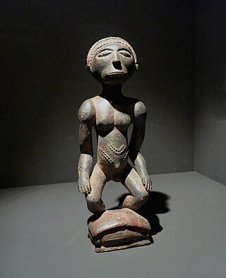
<span class="mw-page-title-main">Congo-Nile Divide</span>

The Congo-Nile Divide or the Nile-Congo Watershed is the continental divide that separates the drainage basins of the Congo and Nile rivers. It is about 2,000 kilometres (1,200 mi) long.

References

  1. Jack 1887, p. 486.
  2. 1 2 Davies & Walker 1986, p. 206.
  3. Blaes 2008.
  4. Klerkx & Imanackunov 2003, p. 241.
  5. Likens 2010, p. 299.
  6. 1 2 3 Clark 1969, p. 35.
  7. Gupta 2008, p. 296.
  8. 1 2 Klerkx & Imanackunov 2003, p. 229.
  9. Likens 2010, p. 294.
  10. Hughes & Hughes 1992, p. 562.
  11. 1 2 Inbar 2010.
  12. Kisangani & Bobb 2010, p. 319.
  13. 1 2 Reefe 1981, p. 124.
  14. Reefe 1981, p. 131.
  15. Reefe 1981, p. 127.
  16. Reefe 1981, p. 126.
  17. Reefe 1981, p. 178.
  18. Blackwood 1877, p. 702.
  19. Cameron 1876, p. 312.
  20. Moore 1878, p. 125.
  21. Burke 1881, p. 435.
  22. O'Brien 2008, p. 91.

Sources

5°40′00″S26°55′00″E / 5.66667°S 26.91667°E / -5.66667; 26.91667