Related Research Articles

The Democratic Republic of the Congo (DRC) is the largest country of sub-Saharan Africa, occupying some 2,344,858 square kilometres (905,355 sq mi). Most of the country lies within the vast hollow of the Congo River basin. The vast, low-lying central area is a plateau-shaped basin sloping toward the west, covered by tropical rainforest and criss-crossed by rivers. The forest center is surrounded by mountainous terraces in the west, plateaus merging into savannas in the south and southwest. Dense grasslands extend beyond the Congo River in the north. High mountains of the Ruwenzori Range are found on the eastern borders with Rwanda and Uganda.

Rwanda is located in East Africa, to the east of the Democratic Republic of the Congo, at the co-ordinates 2°00′S30°0′E.
North Kivu is a province bordering Lake Kivu in the eastern Democratic Republic of the Congo. Its capital is Goma. The 2020 population was estimated to be 8,147,400.

South Kivu is one of 26 provinces of the Democratic Republic of the Congo (DRC). Its capital is Bukavu.

Orientale Province is one of the former provinces of the Democratic Republic of the Congo and its predecessors the Congo Free State and the Belgian Congo. It went through a series of boundary changes between 1898 and 2015, when it was divided into smaller units.

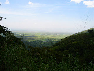
The Ruzizi is a river, 117 kilometres (73 mi) long, that flows from Lake Kivu to Lake Tanganyika in Central Africa, descending from about 1,500 metres (4,900 ft) to about 770 metres (2,530 ft) above sea level over its length. The steepest gradients occur over the first 40 kilometres (25 mi), where hydroelectric dams have been built. Further downstream, the Ruzizi Plain, the floor of the Western Rift Valley, has gentle hills, and the river flows into Lake Tanganyika through a delta, with one or two small channels splitting off from the main channel.

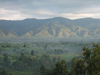
The Albertine Rift is the western branch of the East African Rift, covering parts of Uganda, the Democratic Republic of the Congo (DRC), Rwanda, Burundi and Tanzania. It extends from the northern end of Lake Albert to the southern end of Lake Tanganyika. The geographical term includes the valley and the surrounding mountains.
Semliki River is a major river, 140 kilometres (87 mi) long, in the Democratic Republic of the Congo (DRC) and Uganda in Central and East Africa. It flows north from Lake Edward in Beni Territory, Nord-Kivu, D.R.C avoiding the Rwenzori Mountains on its Right (East), emptying into Lake Albert in the Albertine Rift, Irumu Territory, Ituri Province, D.R.C overlooking the Blue Mountains to its left in the west. Its mouth is near the Village of Katolingo in Kanara subcounty, Ntoroko district, Uganda. Along its lower reaches, it meanders extensively forming part of the international border between the DRC and the western Ugandan districts of Bundibugyo and Ntoroko, near the Semuliki National Park.

Ituri District, later Kibali-Ituri District, was a district of the Belgian Congo and the Democratic Republic of the Congo. It roughly corresponded in area to the present Ituri Province.
Lubutu is a territory in Maniema province of the Democratic Republic of the Congo. The territory contains the southern portion of Maiko National Park. It is bordered to the north and west by Tshopo Province, to the east by North Kivu, and it is bordered to the south by Punia Territory, separated by the Lowa river. The main roads in the territory are the N3 and N31 highways, which intersect at the town of Lubutu. South of the village of Tingi-Tingi, a widened section of the N3 serves as the Tingi-Tingi Airport.

The Congo–Nile Divide or the Nile–Congo Watershed is the continental divide that separates the drainage basins of the Congo and Nile rivers. It is about 2,000 kilometres (1,200 mi) long.

The Kahuzi-Biega National Park is a protected area near Bukavu town in eastern Democratic Republic of the Congo. It is situated near the western bank of Lake Kivu and the Rwandan border. Established in 1970 by the Belgian photographer and conservationist Adrien Deschryver, the park is named after two dormant volcanoes, Mount Kahuzi and Mount Biega, which are within its limits. With an area of 6,000 square kilometres (2,300 sq mi), Kahuzi-Biega is one of the biggest national parks in the country. Set in both mountainous and lowland terrain, it is one of the last refuges of the rare species of Eastern lowland gorilla, an endangered category under the IUCN Red List. The park is a UNESCO World Heritage Site, inscribed in 1980 for its unique biodiversity of rainforest habitat and its eastern lowland gorillas. In 1997, it was listed on the List of World Heritage in Danger because of the political instability of the region, an influx of refugees, and increasing wildlife exploitation.
Lomami National Park is a national park located in the Democratic Republic of the Congo in Central Africa. Situated within the centre basin of the Lomami River, it straddles the Provinces of Tshopo and Maniema, with a slight overlap into the forests of the Tshuapa and Lualaba River basins. Lomami National Park was formally declared on 7 July 2016 as the ninth national park in the country and the first to be created since 1992.
Maniema District was a district of the Belgian Congo and the Democratic Republic of the Congo. It roughly corresponded in area to the present Maniema province.
Kivu District was a district of the Belgian Congo. It was formed from part of Stanleyville District in 1914.

The Districts of the Belgian Congo were the primary administrative divisions when Belgium annexed the Congo Free State in 1908, each administered by a district commissioner. In 1914 they were distributed among four large provinces, with some boundary changes. In 1933 the provinces were restructured into six, again with boundary changes. The number of districts fluctuated between 12 and 26 through splits and consolidations, first rising, then falling, then rising again.

Stanleyville District was a district of the Belgian Congo and Democratic Republic of the Congo. It went through various changes in extent. Between 1933 and 1963 it had roughly the same extent as the current Tshopo province.
Lowa District was a district of the Belgian Congo. It was formed from part of Stanleyville District in 1914, and had been absorbed by Maniema District and Kivu District by 1926.

Sud-Kivu District was a district of the Belgian Congo and the Democratic Republic of the Congo. It roughly corresponded in area to the present South Kivu province.

Nord-Kivu District was a district of the Belgian Congo and the Democratic Republic of the Congo. It roughly corresponded in area to the present North Kivu province.
References
- ↑ "For the Geography Class". New York School Journal. 50: 287. 16 March 1895. Retrieved 18 December 2022– via Google Books.
- ↑ vanden Bossche, J.-P.; Bernacsek, G. M. (1990). Source Book for the Inland Fishery Resources of Africa. Vol. 1. Food and Agriculture Organization of the United Nations. p. 334. ISBN 9789251029831 . Retrieved 18 December 2022.
| Congo left bank (south) |  | |
|---|---|---|
| Kasai basin | ||
| Congo right bank (north) | ||
| Lualaba and tributaries | ||
| Other | ||