Africa is a continent comprising 63 political territories, representing the largest of the great southward projections from the main mass of Earth's surface. Within its regular outline, it comprises an area of 30,368,609 km2 (11,725,385 sq mi), excluding adjacent islands. Its highest mountain is Mount Kilimanjaro, its largest lake is Lake Victoria.

Burundi is located in East Africa, to the east of the Democratic Republic of the Congo, at the coordinates 3°30′S30°0′E.

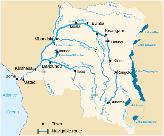
The Democratic Republic of the Congo (DRC) is the largest country of sub-Saharan Africa, occupying some 2,344,858 square kilometres (905,355 sq mi). Most of the country lies within the vast hollow of the Congo River basin. The vast, low-lying central area is a plateau-shaped basin sloping toward the west, covered by tropical rainforest and criss-crossed by rivers. The forest center is surrounded by mountainous terraces in the west, plateaus merging into savannas in the south and southwest. Dense grasslands extend beyond the Congo River in the north. High mountains of the Ruwenzori Range are found on the eastern borders with Rwanda and Uganda.

The Congo River, formerly also known as the Zaire River, is the second longest river in Africa, shorter only than the Nile, as well as the second largest river in the world by discharge volume, following only the Amazon. It is also the world's deepest recorded river, with measured depths around 219.5 m (720 ft). The Congo-Lualaba-Chambeshi River system has an overall length of 4,700 km (2,920 mi), which makes it the world's ninth-longest river. The Chambeshi is a tributary of the Lualaba River, and Lualaba is the name of the Congo River upstream of Boyoma Falls, extending for 1,800 km (1,120 mi).

Rwanda is located in East Africa, to the east of the Democratic Republic of the Congo, at the co-ordinates 2°00′S30°0′E.

Lake Albert, originally known as Lake Mwitanzige and temporarily Lake Mobutu Sese Seko, is a lake located in Uganda and the Democratic Republic of the Congo. It is Africa's seventh-largest lake, as well as the second biggest of Uganda's Great Lakes.
The Lualaba River flows entirely within the eastern Democratic Republic of the Congo. It provides the greatest streamflow to the Congo River, while the source of the Congo is recognized as the Chambeshi. The Lualaba is 1,800 kilometres (1,100 mi) long. Its headwaters are in the country's far southeastern corner near Musofi and Lubumbashi in Katanga Province, next to the Zambian Copperbelt.

The African Great Lakes are a series of lakes constituting the part of the Rift Valley lakes in and around the East African Rift. They include Lake Victoria, the second-largest fresh water lake in the world by area, Lake Tanganyika, the world's second-largest freshwater lake by volume and depth, and Lake Malawi, the world's eighth-largest fresh water lake by area. Collectively, they contain 31,000 km3 of water, which is more than either Lake Baikal or the North American Great Lakes. This total constitutes about 25% of the planet's unfrozen surface fresh water. The large rift lakes of Africa are the ancient home of great biodiversity, and 10% of the world's fish species live in this region.

An inland port is a port on an inland waterway, such as a river, lake, or canal, which may or may not be connected to the sea. The term "inland port" is also used to refer to a dry port.

Rail transport is provided in the Democratic Republic of the Congo by the Société Nationale des Chemins de Fer du Congo (SNCC), the Société commerciale des transports et des ports (SCTP) (previously Office National des Transports until 2011), and the Office des Chemins de fer des Ueles (CFU).

The Jur River is a river in western South Sudan, flowing through the Bahr el Ghazal and Equatoria regions. About 485 kilometres (301 mi) long, it flows north and northeast, joining the Bahr el Ghazal River on the western side of the Sudd wetlands. The Jur River is part of the Nile basin, as the Bahr al-Ghazal flows into the White Nile.

The following outline is provided as an overview of and topical guide to the Democratic Republic of the Congo:

The following outline is provided as an overview of and topical guide to Uganda:

Congo is a 2001 BBC nature documentary series for television on the natural history of the Congo River of Central Africa. In three episodes, the series explores the variety of animals and habitats that are to be found along the river's 4,700 km (2,922 mi) reach.
Lubudi Airport is an airport serving the town of Lubudi in Lualaba Province, Democratic Republic of the Congo. The runway is 15 kilometres (9.3 mi) north of the town.
The Lubudi River is a tributary of the Sankuru River in the Democratic Republic of the Congo (DRC). The mouth of the river is in the Kuba Chiefdom of the Mweka Territory in Kasai Province.