Colonial period
The explorer Henry Morton Stanley visited the region. He wrote that the Ikelemba entered the Congo about 30 miles (48 km) above the Mohindu or Buruki River (Ruki River). [lower-alpha 1] He estimated it would provide 125 miles (201 km) of river course accessible to trade, and said it was the commercial reserve of the Bakuti tribe. The river was about 150 yards (140 m) wide, and had black waters. Stanley speculated that the Ikelemba, Lulungu (Lulonga River) and Mohindu might be connected by a system of channels running through a low jungly forest.
The Ikelemba company was founded in the Congo Free State on 29 October 1898 to exploit the Ikelemba River, with a capital of 500,000 francs. In the first two years the comnpany harvested about 5 tonnes of rubber each month, and cleared 50 hectares (120 acres) to plant coffee, cocoa and rubber trees. After this results were poorer, and the company suffered from the fall in rubber prices. In 1910 all of the company's assets were transferred to the newly formed Société Equatoriale Congolaise Lulonga-Ikelemba.

The Congo River, formerly also known as the Zaire River, is the second-longest river in Africa, shorter only than the Nile, as well as the third-largest river in the world by discharge volume, following the Amazon and Ganges rivers. It is the world's deepest recorded river, with measured depths of around 220 m (720 ft). The Congo-Lualaba-Chambeshi River system has an overall length of 4,700 km (2,900 mi), which makes it the world's ninth-longest river. The Chambeshi is a tributary of the Lualaba River, and Lualaba is the name of the Congo River upstream of Boyoma Falls, extending for 1,800 km (1,100 mi).

The Democratic Republic of the Congo is a country in Central Africa. By land area, the DRC is the second-largest country in Africa and the 11th-largest in the world. With a population of around 105 million, the Democratic Republic of the Congo is the most populous Francophone country in the world. The national capital and largest city is Kinshasa, which is also the economic center. The country is bordered by the Republic of the Congo, Central African Republic, South Sudan, Uganda, Rwanda, Burundi, Tanzania, Zambia, Angola, the Cabinda exclave of Angola, and the South Atlantic Ocean.
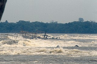
Boyoma Falls, formerly known as Stanley Falls, is a series of seven cataracts, each no more than 5 m (16 ft) high, extending over more than 100 km (62 mi) along a curve of the Lualaba River between the river port towns of Ubundu and Kisangani in the Orientale Province of the Democratic Republic of the Congo. The seven cataracts have a total drop of 61 m (200 ft). They form the largest waterfall by volume of annual flow rate in the world, exceeding both the Niagara Falls and the Iguazu Falls.
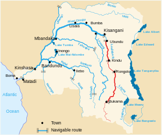
The Lualaba River flows entirely within the eastern part of Democratic Republic of the Congo. It provides the greatest streamflow to the Congo River, while the source of the Congo is recognized as the Chambeshi. The Lualaba is 1,800 kilometres (1,100 mi) long. Its headwaters are in the country's far southeastern corner near Musofi and Lubumbashi in Katanga Province, next to the Zambian Copperbelt.

The Pool Malebo, formerly Stanley Pool, also known as Mpumbu, Lake Nkunda or Lake Nkuna by local indigenous people in pre-colonial times, is a lake-like widening in the lower reaches of the Congo River. The river serves as the border between the Republic of the Congo to the north and the Democratic Republic of the Congo to the south.

Kisangani is the capital of Tshopo province in the Democratic Republic of the Congo. It is the fifth most populous urban area in the country, with an estimated population of 1,312,000 in 2021, and the largest of the cities that lie in the tropical woodlands of the Congo.

Boma is a port town on the Congo River, some 100 kilometres (62 mi) upstream from the Atlantic Ocean, in the Kongo Central Province of the Democratic Republic of the Congo (DRC), adjacent to the border with Angola. It had an estimated population of 162,521 in 2012.
Mbandaka is a city on the Congo River in the Democratic Republic of Congo located near the confluence of the Congo and Ruki rivers. It is the capital of Équateur Province.
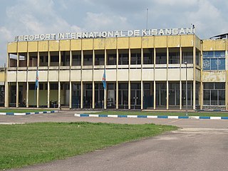
Kisangani Bangoka International Airport is an airport serving Kisangani, Democratic Republic of the Congo. The airport is 12 kilometres (7.5 mi) east of the city. The Bangoka VOR/DME is 1.7 nautical miles (3.1 km) west of the airport.
The Malagarasi River is a river in western Tanzania, flowing through Kigoma Region, although one of its tributaries comes from southeastern Burundi. The river also forms the western border of Tabora Region, the southern border of Kagera Region and the southwestern border of Geita Region. It is the second-longest river in Tanzania behind the Rufiji—Great Ruaha, and has the largest watershed of any river flowing into Lake Tanganyika. The Malagarasi-Muyovozi Wetlands are a designated a Ramsar site. Local tribes have nicknamed the Malagarasi as "the river of bad spirits".
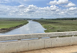
The Ruki is a river in the Democratic Republic of the Congo. It is a left tributary of the Congo River. It may be seen as the lower reach of the Busira River, which in turn may be seen as the lower reach of the Tshuapa River.
The Busira River is a river in the Democratic Republic of the Congo. It is the main tributary of the Ruki River, which in turn is a tributary of the Congo River. The Busira may be seen as the upper reach of the Ruki River. It is navigable year round.

The Yellala Falls are a series of waterfalls and rapids on the Congo River just upstream from Matadi in the Democratic Republic of the Congo. The falls are the lowest of a long series of rapids that render the river unnavigable, forcing colonial explorers to travel by foot as far as the Stanley Pool 350 kilometres (220 mi) upstream. The Congo is the second largest river in the world by volume of water discharged, and the deepest in the world. The section of river that ends with the Yellala falls has over 300 species of fish, many found nowhere else.

Alphonse van Gèle, also written van Gele or Vangele, was a Belgian soldier who served as the Vice-Governor General of the Congo Free State from December 1897 until January 1899. He established the Equator Station, or Station de l’Équateur, today Mbandaka, and concluded a treaty with the powerful Zanzibar trader Tippu Tip at the Stanley Falls station, today Kisangani. He is known for having confirmed that the Uele River was the upper part of the Ubangi River.
Bolomba Territory is an administrative area in Équateur Province in the Democratic Republic of the Congo. The headquarters is the town of Bolomba. It is located northeast of the provincial capital of Mbandaka. Its main waterway is the Ikelemba River which is navigable down to the Congo River.
Stanley Falls District was a district of the Congo Free State. It covered most of the eastern part of the colony along the Congo River south from Stanleyville.

The Tshopo River is a river in the Democratic Republic of the Congo. It flows through the north of the city of Kisangani and joins the Lindi River just before that river enters the Congo River. It gives its name to the province of Tshopo.
Kimpoko is a district within Maluku municipality in the Democratic Republic of the Congo.

The Momboyo River is a river in the Democratic Republic of the Congo. It joins the Busira River to form the Ruki River, a tributary of the Congo River. The Momboya and its main tributary the Luilaka are navigable for 545 kilometres (339 mi) from its mouth.
The Lomela River is a river in the Democratic Republic of the Congo. It is one of the main tributaries of the Busira River, which forms where the Lomela meets the Tshuapa River. The Busira is in turn the main tributary of the Ruki River, which enters the Congo River to the north of Mbandaka.
