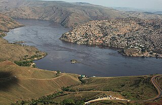
Matadi is the chief sea port of the Democratic Republic of the Congo and the capital of the Kongo Central province, adjacent to the border with Angola. It had a population of 245,862 (2004). Matadi is situated on the left bank of the Congo River, 148 km (92 mi) from the mouth and 8 km (5.0 mi) below the last navigable point before the rapids that make the river impassable for a long stretch upriver.

Lindi is a historic coastal town in southern Tanzania and the administrative center of the Lindi Region, the least populated region in the country. Situated at the head of Lindi Bay along the Indian Ocean, the town is located approximately 105 kilometers north of Mtwara, the southernmost coastal town in Tanzania, and about 450 kilometers south of Dar es Salaam, the nation's largest city.

The Luapula River is a north-flowing river of central Africa, within the Congo River watershed. It rises in the wetlands of Lake Bangweulu (Zambia), which are fed by the Chambeshi River. The Luapula flows west then north, marking the border between Zambia and the Democratic Republic of the Congo before emptying into Lake Mweru. The river gives its name to Zambia's Luapula Province.

The N4 road is a national primary road in Ireland, running from Dublin to the northwest of Ireland and Sligo town. The M6 to Galway diverges from this route after Kinnegad, while the N5 to Westport diverges at Longford town. Most sections of the N4 that are motorway-standard are designated the M4 motorway.

The N5 road is a national primary road in Ireland, connecting Longford town with Westport. It is the main access route from Dublin to most of County Mayo, including the county's largest towns, Castlebar, Ballina, and Westport.

The N1 is a national route in South Africa that runs from Cape Town through Bloemfontein, Johannesburg, Pretoria and Polokwane to Beit Bridge on the border with Zimbabwe. It forms the first section of the famed Cape to Cairo Road.

The N15 road is a national primary road in the north-west of Ireland. It runs from Sligo to Lifford, County Donegal. It forms part of the proposed Atlantic Corridor route. It also goes to the border with Northern Ireland.

The R148 road is one of Ireland's regional roads which was classified following the opening of a bypassed national primary road.

The N59 road is a national secondary road in Ireland. It commences in County Sligo, south of Sligo Town at the Belladrehid interchange with the N4 north of Ballysadare. The route circles around the west of Ireland, passing west from Sligo into County Mayo and through Ballina. The N59 continues around Mayo, proceeding indirectly to Westport. Continuing south through Mayo into County Galway, the road passes through the village of Leenaun. The 182-year-old bridge in the centre of the village, carrying the road across the River Lahill, collapsed in floods on 18 July 2007. Due to the local terrain and road network, the diversionary route for getting from the south of the village to Westport was 110 km long. A temporary bridge was opened eight days after the floods, on 27 July. It has since been replaced by a new bridge.

Lindi Region is one of Tanzania's 31 administrative regions. The region covers an area of 66,040 km2 (25,500 sq mi). The region is comparable in size to the combined land area of the nation state of Sri Lanka. The regional capital is the municipality of Lindi.

The Trans-Gambia Highway is a major highway in The Gambia, running across the centre of the nation in a north–south direction.

The N4 is a national route in South Africa that runs from Skilpadshek on the Botswana border, past Rustenburg, Pretoria, eMalahleni and Mbombela, to Komatipoort on the Mozambique border. The entire route is a toll road.

The R136 road is a regional road in Ireland, located in the southwest of Dublin. Named the Outer Ring Road, the route, which is dual carriageway, runs from the N4 at Lucan to the N81 at Tallaght, bypassing west of Clondalkin and crossing the N7 near Citywest. It was built as part of the planning for the new town of Adamstown.

State Highway 8 is one of New Zealand's eight national highways. It forms an anticlockwise loop through the southern scenic regions of the Mackenzie Basin and Central Otago, starting and terminating in junctions with State Highway 1. Distances are measured from north to south.

The January 1997 flood of the Merced River occurred from December 31, 1996, to January 5, 1997, throughout the Yosemite Valley in Yosemite National Park, Mariposa County, California, US. The flood stands as arguably the park's worst natural disaster to date, and inarguably the worst flood in park history. The Merced River at Happy Isles peaked at 10,100 cubic feet per second during the flood. A book was written on the flood later in 1997 by Mark Goodin titled Yosemite: The 100-Year Flood. It is part of the 1997 California New Years Floods.

The N4 road is one of the 7 national roads in Senegal. It connects central-Senegal with Basse Casamance by a route which crosses The Gambia.

Aureliopolis in Asia is both a Roman era city and a vacant titular see located in the ecumenical province of Asia, in what is today Turkey.
Likati is a town in the Aketi Territory of Bas-Uélé Province in the north of the Democratic Republic of the Congo (DRC).
The Itimbiri River is a right tributary of the Congo River, which it joins above Bumba. At one time it was important as a navigable waterway for transporting good from the northeast of the country down to the Congo.

The Tshopo River is a river in the Democratic Republic of the Congo. It flows through the north of the city of Kisangani and joins the Lindi River just before that river enters the Congo River. It gives its name to the province of Tshopo.

