Lomela River

Last updated
Lomela River
Democratic Republic of the Congo relief location map.jpg
Red pog.svg
Mouth location in the Democratic Republic of the Congo
Location
CountryDemocratic Republic of the Congo
Physical characteristics
Mouth Busira River
  coordinates
0°20′59″S20°46′49″E / 0.3497°S 20.7804°E / -0.3497; 20.7804
Length566 kilometres (352 mi) (navigable)
Basin features
River system RukiBusira

The Lomela River is a river in the Democratic Republic of the Congo. It is one of the main tributaries of the Busira River, which forms where the Lomela meets the Tshuapa River. The Busira is in turn the main tributary of the Ruki River, which enters the Congo River to the north of Mbandaka.

Contents

Location

The Lomela River flows in a northwest direction from the Sankuru Nature Reserve and across the Salonga National Park. The Busira River forms a few miles west of Boende where the Lomela River joins the Tshuapa River from the left. [1]

The Lomela River is navigable from its confluence with the Tshuapa up to the terminus of Lomela, a distance of 566 kilometres (352 mi). It is winding and narrow, and flows through forested and marshy areas that flood in the high water seasons. From the mouth of the river to Itoko, a distance of 236 kilometres (147 mi), it always allows boats with a 1 metre (3 ft 3 in) draft. In high water periods it can take 350 ton barges, and in low water periods can take 150-250 ton barges in this section. From Itoko to Lomami, at 462 kilometres (287 mi) from its mouth, the rocky banks and narrow navigable channels make navigation dangerous. From Lomami up to Lomela the river is open to navigation only from early June to early September, and only for 25 ton barges. In some places the channels are less than 25 metres (82 ft) wide and 0.5 metres (1 ft 8 in) deep. [2]

Environment

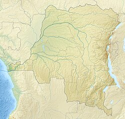
The Lomela flows through the heart of the central depression of the Congo Basin. Rainfall here averages 2,000 millimetres (79 in) annually, with no dry season. The Lomela meanders through a 88,000 hectares (220,000 acres) area of permanent swamp forest from 20°35'E to 21°30'E, and through a 46,500 hectares (115,000 acres) area of swamp forest between 21°50'E and 22°18'E. [3] Part of the river is protected by the Salonga National Park. [4]

Notes

    1. Relation: Lomela (2166127).
    2. Lederer 1973, p. 15.
    3. Hughes 1992, p. 548.
    4. Hughes 1992, p. 554.

    Sources

    Related Research Articles

    <span class="mw-page-title-main">Geography of the Democratic Republic of the Congo</span> Geography

    The Democratic Republic of the Congo (DRC) is the largest country of sub-Saharan Africa, occupying some 2,344,858 square kilometres (905,355 sq mi). Most of the country lies within the vast hollow of the Congo River basin. The vast, low-lying central area is a plateau-shaped basin sloping toward the west, covered by tropical rainforest and criss-crossed by rivers. The forest center is surrounded by mountainous terraces in the west, plateaus merging into savannas in the south and southwest. Dense grasslands extend beyond the Congo River in the north. High mountains of the Ruwenzori Range are found on the eastern borders with Rwanda and Uganda.

    <span class="mw-page-title-main">Congo River</span> River in central Africa

    The Congo River, formerly also known as the Zaire River, is the second-longest river in Africa, shorter only than the Nile, as well as the third largest river in the world by discharge volume, following the Amazon and the Ganges rivers. It is also the world's deepest recorded river, with measured depths of around 219.5 m (720 ft). The Congo-Lualaba-Chambeshi River system has an overall length of 4,700 km (2,920 mi), which makes it the world's ninth-longest river. The Chambeshi is a tributary of the Lualaba River, and Lualaba is the name of the Congo River upstream of Boyoma Falls, extending for 1,800 km (1,120 mi).

    <span class="mw-page-title-main">Lualaba River</span> River in Democratic Republic of the Congo

    The Lualaba River flows entirely within the eastern part of Democratic Republic of the Congo. It provides the greatest streamflow to the Congo River, while the source of the Congo is recognized as the Chambeshi. The Lualaba is 1,800 kilometres (1,100 mi) long. Its headwaters are in the country's far southeastern corner near Musofi and Lubumbashi in Katanga Province, next to the Zambian Copperbelt.

    <span class="mw-page-title-main">Salonga National Park</span>

    Salonga National Park is a national park in the Democratic Republic of the Congo located in the Congo River basin. It is Africa's largest tropical rainforest reserve covering about 36,000 km2 or 3,600,000 hectares. It extends into the provinces of Mai Ndombe, Equateur, Kasaï and Sankuru. In 1984, the national park was inscribed on the UNESCO World Heritage List for its protection of a large swath of relatively intact rainforest and its important habitat for many rare species. In 1999, the site has been listed as endangered due to poaching and housing construction. Following the improvement in its state of conservation, the site was removed from the endangered list in 2021.

    <span class="mw-page-title-main">Malagarasi River</span> River in Tanzania, Burundi

    The Malagarasi River is a river in western Tanzania, flowing through Kigoma Region, although one of its tributaries comes from southeastern Burundi. The river also forms the western border of Tabora Region, the southern border of Kagera Region and the southwestern border of Geita Region. It is the second-longest river in Tanzania behind the Rufiji—Great Ruaha, and has the largest watershed of any river flowing into Lake Tanganyika. The Malagarasi-Muyovozi Wetlands are a designated a Ramsar site. Local tribes have nicknamed the Malagarasi as "the river of bad spirits".

    Sankuru Nature Reserve is a protected area in the Democratic Republic of the Congo. It was created in November 2007 to protect a forest area home to bonobo, okapi and African forest elephant. The reserve has not been managed effectively, and suffers from ongoing deforestation and bushmeat hunting.

    <span class="mw-page-title-main">Tshuapa River</span> River in Democratic Republic of the Congo

    The Tshuapa River or Rivière Tshwapa is a river in Democratic Republic of the Congo, the main tributary of the Busira River.

    The Ruki is a river in the Democratic Republic of the Congo. It is a left tributary of the Congo River. It may be seen as the lower reach of the Busira River, which in turn may be seen as the lower reach of the Tshuapa River.

    The Busira River is a river in the Democratic Republic of the Congo. It is the main tributary of the Ruki River, which in turn is a tributary of the Congo River. The Busira may be seen as the upper reach of the Ruki River. It is navigable year round.

    <span class="mw-page-title-main">Lobaye River</span> River in Central African Republic

    The Lobaye River is a river of the Central African Republic, a right tributary of the Ubangi River.

    <span class="mw-page-title-main">Compagnie du chemin de fer du Congo supérieur aux Grands Lacs africains</span>

    The Compagnie du chemin de fer du Congo supérieur aux Grands Lacs africains was a Belgian railway company established in 1902 in the Congo Free State, later the Belgian Congo, now the Democratic Republic of the Congo. It provided service in the eastern part of the colony south of Stanleyville (Kisangani) to serve the settlers and mining operations in Katanga. It operated a combination of river steamer service along the Lualaba River and railway links where the river was not navigable, including a link to Lake Tanganyika. In 1960 it became the Société congolaise des chemins de fer des Grands Lacs.

    <span class="mw-page-title-main">Momboyo River</span> River in Democratic Republic of the Congo

    The Momboyo River is a river in the Democratic Republic of the Congo. It joins the Busira River to form the Ruki River, a tributary of the Congo River. The Momboya and its main tributary the Luilaka are navigable for 545 kilometres (339 mi) from its mouth.

    The Salonga River is a river in the Democratic Republic of the Congo. It is a tributary of the Busira River.

    Elinga-Mpango or Elingampango is a community in the Sankuru province of the Democratic Republic of the Congo.

    Bokote is a community on the Busira River in the Province of Équateur in the Democratic Republic of the Congo. In the colonial period it held a trading post and a Catholic mission.

    Lotoko is a community on the Busira River in the Province of Équateur in the Democratic Republic of the Congo. In the colonial period it held a trading post.

    Monieka is a community on the Busira River in the Province of Équateur in the Democratic Republic of the Congo. In the colonial period it held a trading post and a Protestant mission.

    Bomputu is a community on the Salonga River in the province of Tshuapa in the Democratic Republic of the Congo. In the colonial period it held a trading post.

    <span class="mw-page-title-main">Upper Noteć Canals</span> Waterway, canals, 1882, Kuyavian-Pomeranian Voivodeship, Poland

    The Upper Noteć Canals are an aggregate of inland water channels in Kuyavian-Pomeranian Voivodeship, Poland. They stem from the upper part of the Noteć river, north of Gopło lake, and mouth at their northern point into the Bydgoszcz Canal, west of the city territory. These canals have been put into operation between the 1770s and the 1880s and are still partly navigable today.