
The A6 is one of the main historic north–south roads in England. It currently runs from Luton in Bedfordshire to Carlisle in Cumbria, although it formerly started at a junction with the A1 at Barnet. It is the fourth longest numbered road in Britain, behind only the A1, A38 and A30.

Bandundu is one of eleven former provinces of the Democratic Republic of the Congo. It bordered the provinces of Kinshasa and Bas-Congo to the west, Équateur to the north, and Kasai-Occidental to the east. The provincial capital is also called Bandundu.

Kasaï-Occidental was one of the eleven provinces of the Democratic Republic of the Congo between 1966 and 2015, when it was split into the Kasaï-Central and the Kasaï provinces.
The Mahanadi is a major river in East Central India. It drains an area of around 141,600 square kilometres (54,700 sq mi) and has a total course of 858 kilometres (533 mi) Mahanadi is also known for the Hirakud Dam. The river flows through the states of Chhattisgarh and Odisha.

The River Dove is the principal river of the southwestern Peak District, in the Midlands of England and is around 45 miles (72 km) in length. It rises on Axe Edge Moor near Buxton and flows generally south to its confluence with the River Trent at Newton Solney. From there, its waters reach the North Sea via the Humber Estuary. For almost its entire course it forms the boundary between the counties of Staffordshire and Derbyshire. The river meanders past Longnor and Hartington and cuts through a set of stunning limestone gorges, Beresford Dale, Wolfscote Dale, Milldale and Dovedale.

The Padma is a major river in Bangladesh and India. It is the main distributary of the Ganges, flowing generally southeast for 120 kilometres (75 mi) to its confluence with the Meghna River near the Bay of Bengal. The city of Rajshahi is situated on the banks of the river. However, over 256 square miles of land, as large as Chicago, has been lost due to erosion of Padma since 1966.

Kananga, formerly known as Luluabourg or Luluaburg, is the capital city of the Kasai-Central Province in the Democratic Republic of the Congo and was the capital of the former Kasaï-Occidental Province. The city has an estimated population of 1,463,556.

The Kikuchi River flows through the northern part of Kumamoto Prefecture, Kyūshū, Japan. The source of the river is Fukaba, Aso city near Mt. Aso at the height of 1041 metres and flows west through the Kikuchi Valley. It turns south near Kikusui and empties into the Shimabara Bay in the Ariake sea. Land reclamation is taking place at its mouth.

Kasai-Oriental is one of the 26 provinces of the Democratic Republic of the Congo. Specified under Article 2 of the country's 2006 Constitution, the new province was finally created in 2015 from Tshilenge District and the independently administered city of Mbuji-Mayi, both part of the larger, pre-2015 Kasai-Oriental province. The new province's territory corresponds to the historic Sud-Kasaï province that existed in the early period of post-colonial Democratic Republic of the Congo between 1963 and 1966.

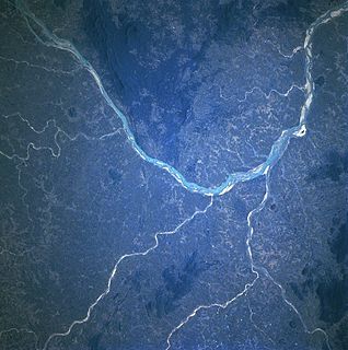
The Sankuru River is a major river in the Democratic Republic of the Congo. Its approximate length of 1,200 km makes it the longest tributary of the Kasai River.

Kangsabati River (Pron:/ˌkæŋsəˈbɑːtɪ/) rises from the Chota Nagpur plateau in the state of West Bengal, India and passes through the districts of Purulia, Bankura and Paschim Medinipur in West Bengal before draining in the Bay of Bengal.
The Passumpsic River is a 22.7-mile-long (36.5 km) tributary of the Connecticut River, in Vermont. Though primarily a Caledonia County river, it is the only river to flow through all three counties of the Northeast Kingdom.

Keleghai River originates at Baminigram, near Dudhkundi, under Sankrail police station ofJhargram district in the Indian state of West Bengal. It flows past Keshiari, Narayangarh, Sabang and Patashpur to join the Kasai at Tangrakhali under Mahisadal police station of Purba Medinipur district. The combined stream is called Haldi. It is 121 kilometres (75 mi) long. The steep slope of the river in Guptamani and Sankrail causes floods. The river has been so named by the Lodhas.

Dibaya-Lubwe is a town in the Kwilu Province of the Democratic Republic of the Congo. It is in Idiofa Territory. The town lies on the south shore of the Kasai River just below the point where it is joined by the Lubue River. As of 2012 the population was estimated to be 38,933.
The Kamtsha River is a tributary of the Kasai River. The river flows north through Idiofa Territory in Kwilu District, Democratic Republic of the Congo to its mouth on the Kasai River.
The Luele River runs from south to north through Idiofa Territory, Kwilu District, Democratic Republic of the Congo. The river starts as a clear stream in a small valley near Idiofa. It grows in size rapidly due to many small tributaries, among which is the Punkulu River, and then meanders through a large valley before entering the Kasai River downstream from Mangai.
Eolo is a community in Idiofa Territory, in the Kwilu Province of the Democratic Republic of the Congo. It lies on the south shore of the Kasai River just downstream from the mouth of the Kamtsha River.

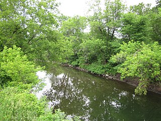
The Sheldrake River is a freshwater stream located in Southern Westchester County, New York. The river forms in White Plains and flows six miles (9.7 km) south until it joins the Mamaroneck River. Approximately 1.58 miles (2.54 km) of the Sheldrake River flow through Scarsdale, 2.13 miles (3.43 km) through New Rochelle and two miles (3.2 km) through the Town of Mamaroneck.
