
Ethiopia is located in the Horn of Africa. It is bordered by Eritrea to the north, Djibouti and Somalia to the east, Sudan and South Sudan to the west, and Kenya to the south. Ethiopia has a high central plateau, the Abyssinian Highlands that varies from 1,290 to 3,000 m above sea level, with some 25 mountains whose peaks rise over 4,000 meters (13,200ft), the highest being Ras Dashen at 4,543 meters (14,538ft).

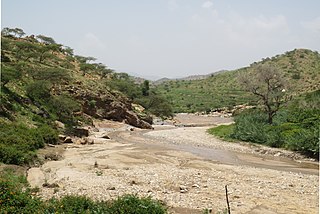
The Atbarah River, also referred to as the Red Nile and / or Black Nile, is a river in northeast Africa. It rises in northwest Ethiopia, approximately 50 km north of Lake Tana and 30 km west of Gondar. It then flows about 805 km (500 mi) to the Nile in north-central Sudan, joining it at the city of Atbarah. The river's tributary, the Tekezé (Setit) River, is perhaps the true upper course of the Atbarah, as the Tekezé follows the longer course prior to the confluence of the two rivers in northeastern Sudan. The Atbarah is the last tributary of the Nile before it reaches the Mediterranean.

The Tekezé or Täkkäze River, also spelled Takkaze, is a major river of Ethiopia. For part of its course it forms a section of the westernmost border of Ethiopia and Eritrea. The river is also known as the Setit as it joins the Nile tributary Atbarah River just over the border in Sudan. According to materials published by the Ethiopian Central Statistical Agency, the Tekezé River is 608 kilometers (378 mi) long. The canyon which it has created is the deepest in Africa and one of the deepest in the world, at some points having a depth of over 2000 meters.

The Mareb River, or Gash River is a river flowing out of central Eritrea. Its chief importance is defining part of the boundary between Eritrea and Ethiopia, between the point where the Mai Ambassa enters the river at 14°53.6′N37°54.8′E to the confluence of the Balasa with the Mareb at 14°38′N39°1.3′E.

Anseba Region is an administrative region of Eritrea, located in northern Eritrea. The capital and the most populous city in the region is Keren. The region is named after Anseba River, which passed through most parts of the region. The average elevation in the region is around 1,800 m (5,900 ft) to 2,100 m (6,900 ft). The hottest month is May recording temperatures up to 30 °C (86 °F), while the coldest month is December to February when it reaches freezing temperature. The region received around 508 mm (20.0 in) of rainfall and the soil is conducive for agriculture.

Agordat, ኣቑርደት is a city in Gash-Barka, Eritrea. It was the capital of the former Barka Province, which was situated between the present-day Gash-Barka and Anseba regions.

The Barka River is a tributary river that flows from the Eritrean Highlands to the plains of Sudan. With a length of over 640 km, it rises just outside Asmara and flows in a northwestern direction through Agordat. The river merges with the Anseba River near the border with Sudan.
The Anseba River is a tributary of the Barka River in Eritrea with a length of 346 kilometers. It rises in the Eritrean Highlands outside Asmara and flows in a northwestern direction through Keren. It merges with the Barka River near the border with Sudan.
The Wokiro River is a seasonal watercourse in Eritrea. It ends north of Massawa, at the Red Sea. Prior to its terminus, the Wokiro merges with the Wadi Laba River.
The Comaile River has its source between the towns of Adi Keyh and Senafe. It flows down the Eastern Escarpment of Eritrea until the small town of Foro near the Red Sea coast. At this point it merges with two other rivers, the Aligide River and the Haddas River. From this point it continues until it empties into the Red Sea.
The Eritrean Highlands are a mountainous region in central Eritrea. Bordered to the south by the Mareb River, it is a northern continuation of the Ethiopian Highlands. The region has seen tremendous deforestation since the colonial period, which began in the late 19th century. The Highlands are at particular risk of deforestation and associated soil erosion. Furthermore, the region, lying south of the Sahel are at particular risk of desertification and frequent drought. The Highlands experience, as most tropical regions, two seasons; the rainy season (kremti) is from June–September while the dry season (haggai) is from September to June. The average temperature for Asmara, which is 2,340 m (7,677 ft) above sea level, is approximately 16 °C (61 °F), but other places range from about 10 to 25 °C.

The Obel River is a right tributary of the Mareb (Gash) river. The latter watercourse forms part of the border between Eritrea and Ethiopia, with its headwaters in the Eritrean Highlands.
Logo Anseba Subregion is a subregion in the eastern Gash-Barka Region of Eritrea. Its capital lies at Logo Anseba.
Gash-Setit is a 709 km2 (274 sq mi) designated national wildlife reserve and historical area of western Eritrea where its considered to be the northern most point of Africa for elephant habitat. It is located in much of Omhajer District and Haykota District between south west of Haykota and the market town of Tesseney in the Gash-Barka region. The name is derived from the two rivers, the Gash and the Setit (Tekezé) River. It is the historical area of the Kunama people and a very fertile region extending to the Sudan border.

The Nubian wild ass is the nominate subspecies of African wild ass, and one of the ancestors of the domestic donkey, which was domesticated about 6,000 years ago. It is presumed to be extinct, though two populations potentially survive on the Caribbean island of Bonaire and in Gebel Elba.
Khashm el-Girba is a town in Kassala (state), north-eastern Sudan, located on the Atbarah River. The Khashm el-Girba Dam is located about 4 km (2 mi) south of the town.
Mereb Melash, also known as Midri Bahr, Ma'ikele Bahr or Bahr Melash was a semi-autonomous province located north of the Mareb River, in the Eritrean highlands (Kebassa) and some surrounding areas. Mereb Melash corresponds to the administrative territory ruled by the Bahr Negash in medieval times. Mereb Melash comprised the historical provinces of Hamasien and Seraye.
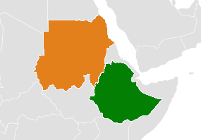
The Ethiopia–Sudan border is a disputed border between the 0929 4715 52 1000000
