
Batken Region is a region of Kyrgyzstan. Its capital is Batken. It is bounded on the east by Osh Region, on the south, west and north by Tajikistan, and on the northeast by Uzbekistan. The northern part of the region is part of the flat, agricultural Ferghana Valley. The land rises southward to the mountains on the southern border: the Alay Mountains in the east, and the Turkestan Range in the west. Its total area is 17,048 km2 (6,582 sq mi). The resident population of the region was 548,247 as of January 2021. The region has sizeable Uzbek and Tajik minorities.

The Mareb River, also known as the Gash River, is a river flowing out of central Eritrea. Its chief importance is defining part of the boundary between Eritrea and Ethiopia, between the point where the Mai Ambassa enters the river at 14°53.6′N37°54.8′E to the confluence of the Balasa with the Mareb at 14°38′N39°1.3′E.
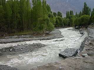
Shigar River is located in the mountainous Baltistan region of northern Pakistan. The Shigar is formed from the melted water of the Baltoro Glacier and Biafo Glacier. It flows through the Shigar Valley. The river is a tributary to the Indus River and meets the Indus in Skardu Valley. The Shigar is the main right-bank tributary of the Indus River Valley in the Skardu Valley.
The Wadi Laba River is a seasonal spate river in Eritrea that typically produces turbulent flow events of only a few hours duration, and only five to ten times during the short summer season. It empties north of Massawa into the Red Sea. Prior to its end, the river merges with the Wokiro River.
The Wokiro River is a seasonal watercourse in Eritrea. It ends north of Massawa, at the Red Sea. Prior to its terminus, the Wokiro merges with the Wadi Laba River.
Debre Mariam is a monastery in Qohayn Eritrea, founded by Abba Absadi, a disciple of the monk Ewostatewos between 1340-1350. The monastery is located at the confluence of the Obel and Gash Rivers. Since its founding the monastery acquired an extravagant manuscript library. Debre Mariam was the preeminent monastery in Eritrea until Debre Bizen surpassed it.
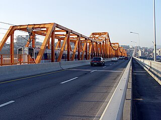
Dongho Bridge is a bridge over the Han River in Seoul, South Korea. It carries road traffic and Seoul Subway Line 3. Oksu station is located at the northern end of this bridge.

Acehúche is a municipality located in the province of Cáceres, Extremadura, Spain. According to the 2006 census (INE), the municipality has a population of 866 inhabitants.
Foro subregion is a subregion in the Northern Red Sea region of Eritrea. Its capital lies at Foro.
Şırlan is a village in the Shusha District of Azerbaijan.

Lachin District is one of the 66 districts of Azerbaijan. It is located in the west of the country, belonging to the East Zangezur Economic Region. The district borders the districts of Kalbajar, Khojaly, Shusha, Khojavend, Qubadli, and the Syunik Province of Armenia. Its capital and largest city is Lachin. As of 2020, the district had a nominal population of 78,600.
The Cadwallader Range, originally named the Cadwallader Mountains, is a sub-range of the Pacific Ranges of the Coast Mountains in the Bridge River-Lillooet Country of the South-Central Interior of British Columbia, Canada, located between the south end of Anderson Lake (E) and the Hurley River. According to the provincial basemap, the precise alpine boundaries of the range are McGilliray Pass, at its eastern extremity and beyond which is the Bendor Range, and the pass between Noel and Sockeye Creeks on its west, which is immediately north of the lower end of Birkenhead Lake. The officially unnamed range west of that has been called the Noel Range, after its main peak Mount Noel. At the foot of the range along its northeast flank is Cadwallader Creek, scene of the historic and once-rich Bralorne and Pioneer Mines and the ghost town of Bralorne.

Veskimäe is a village in Kastre Parish, Tartu County in eastern Estonia.
Sekayam River is a river of Borneo, West Kalimantan province, Indonesia. It is a tributary of the Kapuas River. The Public Forest System Utility Program has a scheme on the river aimed at reducing the level of mercury content absorbed by humans.

Houyan is a station on Line 3 of the Dalian Metro in Liaoning Province, China. It is located in the Ganjingzi District of Dalian City.
Ely is an unincorporated community in Marion County, in the U.S. state of Missouri.
Pleasant View is an unincorporated community in Fayette County, in the U.S. state of Ohio.
Beasley Run is a stream in the U.S. state of Ohio. The 3.6-mile (5.8 km) long stream is a tributary of Sevenmile Creek.
Saint Johns Creek is a stream in Franklin County in the U.S. state of Missouri. It is a tributary of the Missouri River.
Maud is an unincorporated community in Shelby County, in the U.S. state of Missouri.

