Zula ግእዝ ዙላ saba ሰብኣ 𐩸𐩡 is a small town in central Eritrea. It is situated near the head of Annesley Bay, on the Red Sea coast. Four kilometers away is the archeological site of Adulis, which was an emporium and the port of Axum.
Howland is a town in Penobscot County, Maine, United States, which was settled in 1818. It was named after John Howland, one of the passengers on the Mayflower. The population was 1,094 at the 2020 census.

Hwacheon County is a county in Gangwon Province, South Korea. The northern border is, in some places, within nine kilometres of the Korean Demilitarized Zone. Neighboring counties are Cheorwon to the northwest and north, Yanggu to the east, Chuncheon to the south, and the Gyeonggi-do province to the southwest. The county consists largely of mountains and rivers, between which are small farming communities, military bases and military training grounds. The area is renowned for its rivers, lake trout, indigenous otters, and natural scenery.

The Mareb River, also known as the Gash River, is a river flowing out of central Eritrea. Its chief importance is defining part of the boundary between Eritrea and Ethiopia, between the point where the Mai Ambassa enters the river at 14°53.6′N37°54.8′E to the confluence of the Balasa with the Mareb at 14°38′N39°1.3′E.

Dallol is a locality in the Dallol woreda of northern Ethiopia. Located in Kilbet Rasu, Afar Region in the Afar Depression, it has a latitude and longitude of 14°14′19″N40°17′38″E with an elevation of about 130 metres (430 ft) below sea level. The Central Statistical Agency has not published an estimate for the 2005 population of the village, which has been described as a ghost town.
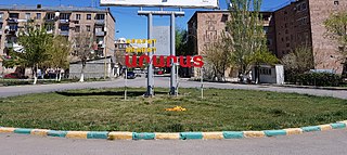
Ararat is a town in the Ararat Municipality of the Ararat Province of Armenia, located on the Yerevan-Nakhchivan highway, 42 km (26 mi) southeast of the capital Yerevan and 19 km (12 mi) south of the provincial centre Artashat. In the 2011 census, the population of the town was 20,235. As per the 2016 official estimate, the population is around 20,300. In the 2022 census, the population of the town was 16,592.
The Wadi Laba River is a seasonal spate river in Eritrea that typically produces turbulent flow events of only a few hours duration, and only five to ten times during the short summer season. It empties north of Massawa into the Red Sea. Prior to its end, the river merges with the Wokiro River.
The Wokiro River is a seasonal watercourse in Eritrea. It ends north of Massawa, at the Red Sea. Prior to its terminus, the Wokiro merges with the Wadi Laba River.
The Damas River is a seasonal river in Eritrea. It passes outside the town of Ghinda.
The Comaile River has its source between the towns of Adi Keyh and Senafe. It flows down the Eastern Escarpment of Eritrea until the small town of Foro near the Red Sea coast. At this point it merges with two other rivers, the Aligide River and the Haddas River. From this point it continues until it empties into the Red Sea.
The Aligide River is a watercourse in Eritrea. It has its source a short distance outside of the national capital, Asmara. The river flows down the Eastern Escarpment of Eritrea until the small town of Foro near the Red Sea coast. At this point, the Aligide merges with two other rivers, the Comaile River and the Haddas River. It continues from there until it empties into the Red Sea.
Foro is a town in the Northern Red Sea region of Eritrea.
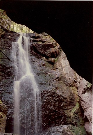
Royalston Falls is a 50 foot (15 m) waterfall and granite gorge located in Royalston, Massachusetts along Falls Brook, a tributary of the Tully River which in turn is a tributary of the Millers River. The falls are part of a 217-acre (88 ha) open space preserve acquired in 1951 by the land conservation non-profit organization The Trustees of Reservations. The 22-mile (35 km) Tully Trail and the 235-mile (378 km) New England National Scenic Trail pass through the property.
Foro Subregion is a subregion in the Northern Red Sea region of Eritrea. Its capital lies at Foro.

Pilgrims Knob is an unincorporated community in Buchanan County, Virginia, United States. As of the 2000 census, the Pilgrims Knob area had a population of 479. It is located at 37°14′19″N81°54′44″W along the Dismal River, part of the watershed of the Big Sandy River, at the junction of Virginia State Routes 638 and 680.

The Retriever Soccer Park is a soccer-specific stadium and one of the University of Maryland, Baltimore County's athletic fields. It is located in the southeastern section of the campus next to the UMBC Stadium, the Department of Facilities Management, and bordered by Shelbourne Road in Arbutus, Maryland. The stadium was completed in the fall of 1998 and included a 120-yard by 70-yard field, press box, automated electronic scoreboard display, and concessions area.
Meigs Creek is a stream in the U.S. state of Ohio. It is a tributary of the Muskingum River.
Gore is an unincorporated community in southwest Warren County, in the U.S. state of Missouri. The community lies on the north edge of the Missouri River Valley. Missouri Route 94 passes just north of the community and the Katy Trail passes the location. The Loutre Slough joins the Missouri River just south of the community.

Stadio Marco Lorenzon is a multi-use stadium in Rende, Italy. It is currently used mostly for football matches and is the home ground of Rende Calcio. The stadium holds 5,000.
Danas Run is a stream in the U.S. state of Ohio. It is a tributary to the Ohio River.
