
The Mareb River, also known as the Gash River, is a river flowing out of central Eritrea. Its chief importance is defining part of the boundary between Eritrea and Ethiopia, between the point where the Mai Ambassa enters the river at 14°53.6′N37°54.8′E to the confluence of the Balasa with the Mareb at 14°38′N39°1.3′E.

The Eritrean–Ethiopian War, also known as the Badme War, was a major armed conflict between Ethiopia and Eritrea that took place from May 1998 to June 2000.
Aboite is an unincorporated community in Lafayette Township, Allen County, in the U.S. state of Indiana.
The Wadi Laba River is a seasonal spate river in Eritrea that typically produces turbulent flow events of only a few hours duration, and only five to ten times during the short summer season. It empties north of Massawa into the Red Sea. Prior to its end, the river merges with the Wokiro River.
The Haddas River is a seasonal river in Eritrea. Outside of the small town of Foro in the central part of the nation, the watercourse merges with the Comaile and Aligide rivers. The combined river flows south of Massawa, emptying into the Red Sea. Silt carried down in the river has led to the burial of the ancient town of Adulis.
The Comaile River has its source between the towns of Adi Keyh and Senafe. It flows down the Eastern Escarpment of Eritrea until the small town of Foro near the Red Sea coast. At this point it merges with two other rivers, the Aligide River and the Haddas River. From this point it continues until it empties into the Red Sea.
The Aligide River is a watercourse in Eritrea. It has its source a short distance outside of the national capital, Asmara. The river flows down the Eastern Escarpment of Eritrea until the small town of Foro near the Red Sea coast. At this point, the Aligide merges with two other rivers, the Comaile River and the Haddas River. It continues from there until it empties into the Red Sea.
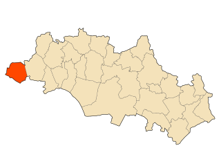
Foro is a town in the Northern Red Sea region of Eritrea.

Tapee College is a private college in the city of Surat Thani, Surat Thani Province, Thailand. The college was established in 1999 and named after the major river of the province.

The Obel River is a right tributary of the Mareb (Gash) river. The latter watercourse forms part of the border between Eritrea and Ethiopia, with its headwaters in the Eritrean Highlands.
The River to River Greenway is a paved multi-use trail in development in Dakota County, Minnesota, United States. Phase II, completed in October 2007, is a 1.3-mile (2.1 km) segment that parallels Minnesota State Highway 110 from Charlton Street to Dodd Road.
Foro Subregion is a subregion in the Northern Red Sea region of Eritrea. Its capital lies at Foro.
Mount Gunanoot is a mountain in the Spatsizi Plateau of the North-Central Interior of British Columbia, Canada, located just east of the headwaters of the Spatsizi River. It is named for Simon Gunanoot, a Gitxsan packer, entrepreneur and erstwhile fugitive who was hunted for several years before turning himself in for trial and being acquitted. Gunanoot is responsible for "opening up" most of the country in this region.

The Seven Ranges was a land tract in eastern Ohio that was the first tract to be surveyed in what became the Public Land Survey System. The tract is 42 miles (68 km) across the northern edge, 91 miles (146 km) on the western edge, with the south and east sides along the Ohio River. It consists of all of Monroe, Harrison, Belmont and Jefferson, and portions of Carroll, Columbiana, Tuscarawas, Guernsey, Noble, and Washington County.
Bir Chouhada is a town and commune in Oum El Bouaghi Province, Algeria. According to the 1998 census it has a population of 8356.

Mamure Castle is a medieval castle in the Bozdoğan village, Anamur ilçe (district) of Mersin Province, Turkey.
Davidsburg is an unincorporated community in York County, Pennsylvania, United States. Davidsburg is located in Dover Township, three miles west of Weigelstown.
Brinley is an unincorporated community in Preble County, in the U.S. state of Ohio.
Bear Creek is a stream in Platte County in the U.S. state of Missouri. It is a tributary of the Missouri River.
