Eritrea is an ancient name, associated in the past with its Greek form Erythraia, Ἐρυθραία, and its derived Latin form Erythræa. This name relates to that of the Red Sea, then called the Erythræan Sea, from the Greek for "red", ἐρυθρός, erythros. But earlier Eritrea was called Mdre Bahri. The Italians created the colony of Eritrea in the 19th century around Asmara and named it with its current name. After World War II, Eritrea annexed to Ethiopia. Following the communist Ethiopian government's defeat in 1991 by the coalition created by armed groups notably the EPLF, Eritrea declared its independence. Eritrea officially celebrated its 1st anniversary of independence on May 24, 1993.

Eritrea is located in the Horn of Africa and is bordered on the northeast and east by the Red Sea, on the west and northwest by Sudan, on the south by Ethiopia, and on the southeast by Djibouti. The country has a high central plateau that varies from 1,800 to 3,000 meters (5,906–9,843 ft) above sea level. A coastal plain, western lowlands, and some 350 islands comprise the remainder of Eritrea's land mass.
Zula ግእዝ ዙላ saba ሰብኣ 𐩸𐩡 is a small town in central Eritrea. It is situated near the head of Annesley Bay, on the Red Sea coast. Four kilometers away is the archeological site of Adulis, which was an emporium and the port of Axum.

The Mareb River, also known as the Gash River, is a river flowing out of central Eritrea. Its chief importance is defining part of the boundary between Eritrea and Ethiopia, between the point where the Mai Ambassa enters the river at 14°53.6′N37°54.8′E to the confluence of the Balasa with the Mareb at 14°38′N39°1.3′E.

The Nubian Desert is in the eastern region of the Sahara Desert, spanning approximately 400,000 km2 of northeastern Sudan and northern Eritrea, between the Nile and the Red Sea. The arid region is rugged and rocky and contains some dunes, and many wadis that die out before reaching the Nile. The average annual rainfall in the Nubian Desert is less than 5 inches (130 mm).
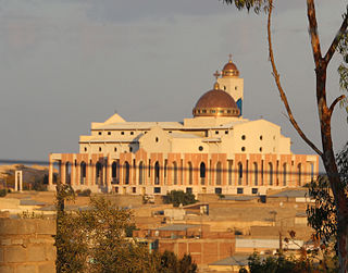
Dekemhare is a town in Eritrea in the Southern Region, southeast of the national capital of Asmara. During the Italian colonial period, the town became a major center of industry and agriculture known for its vineyards. The town became known for Art Deco buildings built during the colonial period.
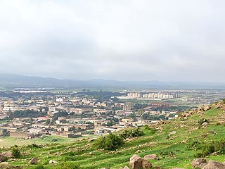
Adi Keyh, is a market town in Eritrea, lying approximatively 110 kilometers southeast of Asmara. It lies almost 2,500 metres above sea level and has a population of around 40,000 people. They speak Tigrinya and saho. The ruins of Qohaito and Toconda lie near the town. Eritrea's College of Science and Arts, which cost $17 million to construct, is located in Adi Keih.

The Buri Peninsula extends from central Eritrea north into the Red Sea.

The Northern Red Sea Region, is an administrative region of Eritrea. It lies along the northern three quarters of the Red Sea, and includes the Dahlak Archipelago and the coastal city of Massawa.

Nefasit, also known as Tappa Nefasit, is a small town in the Northern Red Sea Region of Eritrea. Monastery of Debre Bizen is located at the mountains above.

The Barka River is a tributary river that flows from the Eritrean Highlands to the plains of Sudan. With a length of over 640 km, it rises just outside Asmara and flows in a northwestern direction through Agordat. The river merges with the Anseba River near the border with Sudan.
The Wadi Laba River is a seasonal spate river in Eritrea that typically produces turbulent flow events of only a few hours duration, and only five to ten times during the short summer season. It empties north of Massawa into the Red Sea. Prior to its end, the river merges with the Wokiro River.
The Wokiro River is a seasonal watercourse in Eritrea. It ends north of Massawa, at the Red Sea. Prior to its terminus, the Wokiro merges with the Wadi Laba River.
The Haddas River is a seasonal river in Eritrea. Outside of the small town of Foro in the central part of the nation, the watercourse merges with the Comaile and Aligide rivers. The combined river flows south of Massawa, emptying into the Red Sea. Silt carried down in the river has led to the burial of the ancient town of Adulis.
The Aligide River is a watercourse in Eritrea. It has its source a short distance outside of the national capital, Asmara. The river flows down the Eastern Escarpment of Eritrea until the small town of Foro near the Red Sea coast. At this point, the Aligide merges with two other rivers, the Comaile River and the Haddas River. It continues from there until it empties into the Red Sea.
Foro is a town in the Northern Red Sea region of Eritrea.
Foro Subregion is a subregion in the Northern Red Sea region of Eritrea. Its capital lies at Foro.
Ghinda Subregion is a subregion in the Northern Red Sea region of Eritrea. Its capital lies at Ghinda.
Massawa Subregion is a subregion in the Northern Red Sea region of Eritrea. Its capital lies at Massawa.
Eritrea, officially the State of Eritrea, is a country in the Horn of Africa region of Eastern Africa, with its capital and largest city being Asmara. It is bordered by Ethiopia in the south, Sudan in the west, and Djibouti in the southeast. The northeastern and eastern parts of Eritrea have an extensive coastline along the Red Sea. The nation has a total area of approximately 117,600 km2 (45,406 sq mi), and includes the Dahlak Archipelago and several of the Hanish Islands.
