
Eritrea is located in the Horn of Africa and is bordered on the northeast and east by the Red Sea, on the west and northwest by Sudan, on the south by Ethiopia, and on the southeast by Djibouti. The country has a high central plateau that varies from 1,800 to 3,000 meters (5,906–9,843 ft) above sea level. A coastal plain, western lowlands, and some 350 islands comprise the remainder of Eritrea's land mass.
Zula ግእዝ ዙላ saba ሰብኣ 𐩸𐩡 is a small town in central Eritrea. It is situated near the head of Annesley Bay, on the Red Sea coast. Four kilometers away is the archeological site of Adulis, which was an emporium and the port of Axum.

Ethiopia is located in the Horn of Africa. It is bordered by Eritrea to the north, Djibouti and Somalia to the east, Sudan and South Sudan to the west, and Kenya to the south. Ethiopia has a high central plateau, the Abyssinian Highlands that varies from 1,290 to 3,000 m above sea level, with some 25 mountains whose peaks rise over 4,000 meters (13,200ft), the highest being Ras Dashen at 4,543 meters (14,538ft).

The Mareb River, also known as the Gash River, is a river flowing out of central Eritrea. Its chief importance is defining part of the boundary between Eritrea and Ethiopia, between the point where the Mai Ambassa enters the river at 14°53.6′N37°54.8′E to the confluence of the Balasa with the Mareb at 14°38′N39°1.3′E.

The Buri Peninsula extends from central Eritrea north into the Red Sea.

The Northern Red Sea Region, is an administrative region of Eritrea. It lies along the northern three quarters of the Red Sea, and includes the Dahlak Archipelago and the coastal city of Massawa.
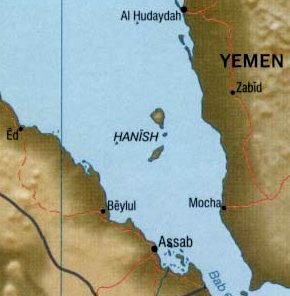
The Hanish Islands conflict was a dispute between Yemen and Eritrea over the island of Greater Hanish in the Red Sea, one of the largest in the then disputed Zukur-Hanish archipelago. Fighting took place over three days from 15 December to 17 December 1995. In 1998 the Permanent Court of Arbitration determined that the territory belonged to Yemen.

Nefasit, also known as Tappa Nefasit, is a small town in the Northern Red Sea Region of Eritrea. Monastery of Debre Bizen is located at the mountains above.

The Barka River is a tributary river that flows from the Eritrean Highlands to the plains of Sudan. With a length of over 640 km, it rises just outside Asmara and flows in a northwestern direction through Agordat. The river merges with the Anseba River near the border with Sudan.
The Wadi Laba River is a seasonal spate river in Eritrea that typically produces turbulent flow events of only a few hours duration, and only five to ten times during the short summer season. It empties north of Massawa into the Red Sea. Prior to its end, the river merges with the Wokiro River.
The Wokiro River is a seasonal watercourse in Eritrea. It ends north of Massawa, at the Red Sea. Prior to its terminus, the Wokiro merges with the Wadi Laba River.
The Haddas River is a seasonal river in Eritrea. Outside of the small town of Foro in the central part of the nation, the watercourse merges with the Comaile and Aligide rivers. The combined river flows south of Massawa, emptying into the Red Sea. Silt carried down in the river has led to the burial of the ancient town of Adulis.
The Comaile River has its source between the towns of Adi Keyh and Senafe. It flows down the Eastern Escarpment of Eritrea until the small town of Foro near the Red Sea coast. At this point it merges with two other rivers, the Aligide River and the Haddas River. From this point it continues until it empties into the Red Sea.
Foro is a town in the Northern Red Sea region of Eritrea.
Foro Subregion is a subregion in the Northern Red Sea region of Eritrea. Its capital lies at Foro.
Ghinda Subregion is a subregion in the Northern Red Sea region of Eritrea. Its capital lies at Ghinda.
Massawa Subregion is a subregion in the Northern Red Sea region of Eritrea. Its capital lies at Massawa.
Eritrea, officially the State of Eritrea, is a country in the Horn of Africa region of Eastern Africa, with its capital and largest city being Asmara. It is bordered by Ethiopia in the south, Sudan in the west, and Djibouti in the southeast. The northeastern and eastern parts of Eritrea have an extensive coastline along the Red Sea. The nation has a total area of approximately 117,600 km2 (45,406 sq mi), and includes the Dahlak Archipelago and several of the Hanish Islands.
