Related Research Articles

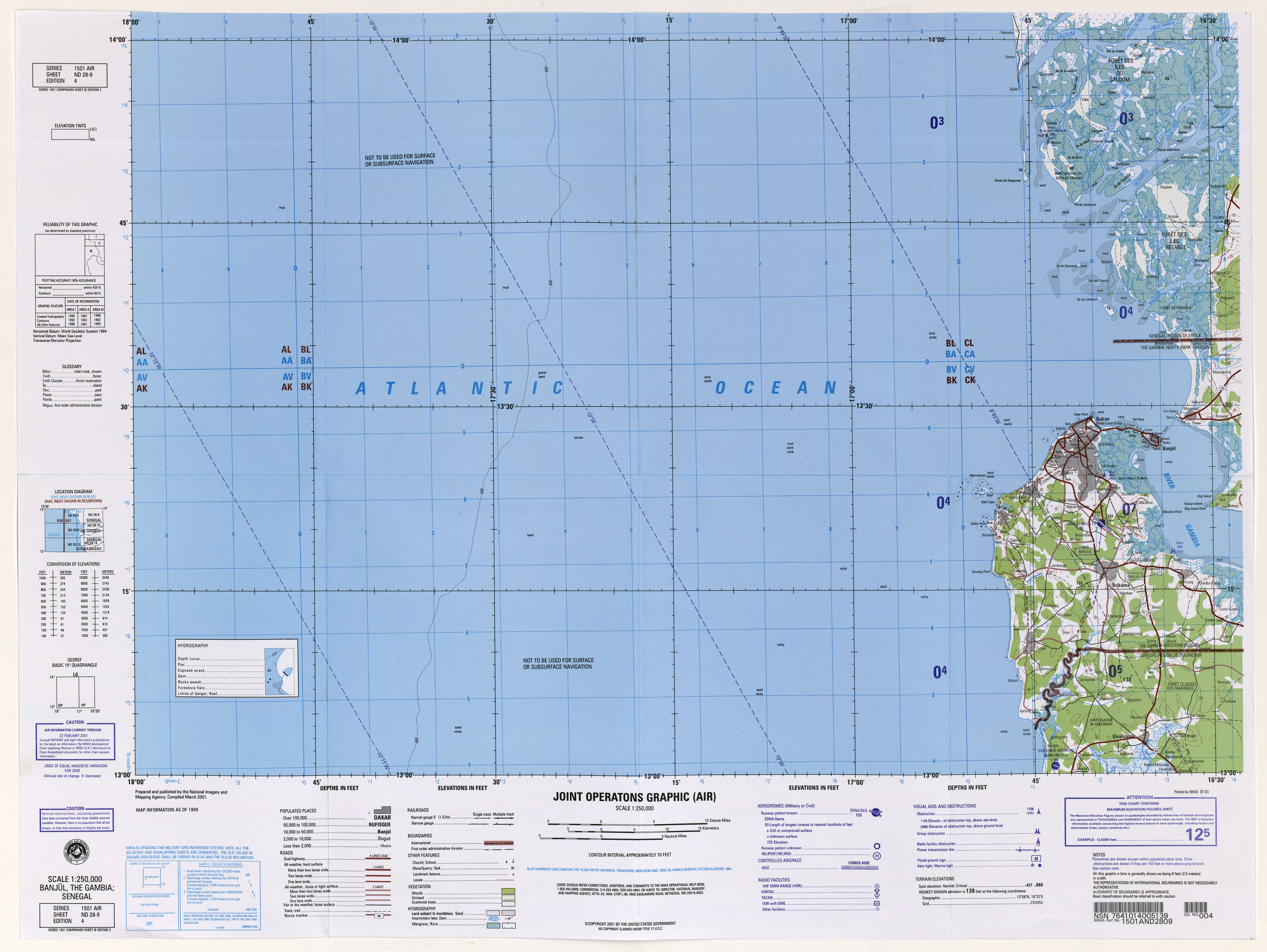
The Gambia is a very small and narrow African country with the border based on the Gambia River. The country is less than 48 kilometres (30 mi) wide at its greatest width. The country's present boundaries were defined in 1889 after an agreement between the United Kingdom and France. It is often claimed by Gambians that the distance of the borders from the Gambia River corresponds to the area that British naval cannon of the time could reach from the river's channel. However, there is no historical evidence to support the story, and the border was actually delineated using careful surveying methods by the Franco-British boundary commission. The Gambia is almost an enclave of Senegal and is the smallest country on mainland Africa.

The National Geospatial-Intelligence Agency (NGA) is a combat support agency within the United States Department of Defense whose primary mission is collecting, analyzing, and distributing geospatial intelligence (GEOINT) in support of national security. Initially known as the National Imagery and Mapping Agency (NIMA) from 1996 to 2003, it is a member of the United States Intelligence Community.

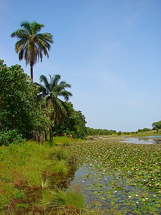
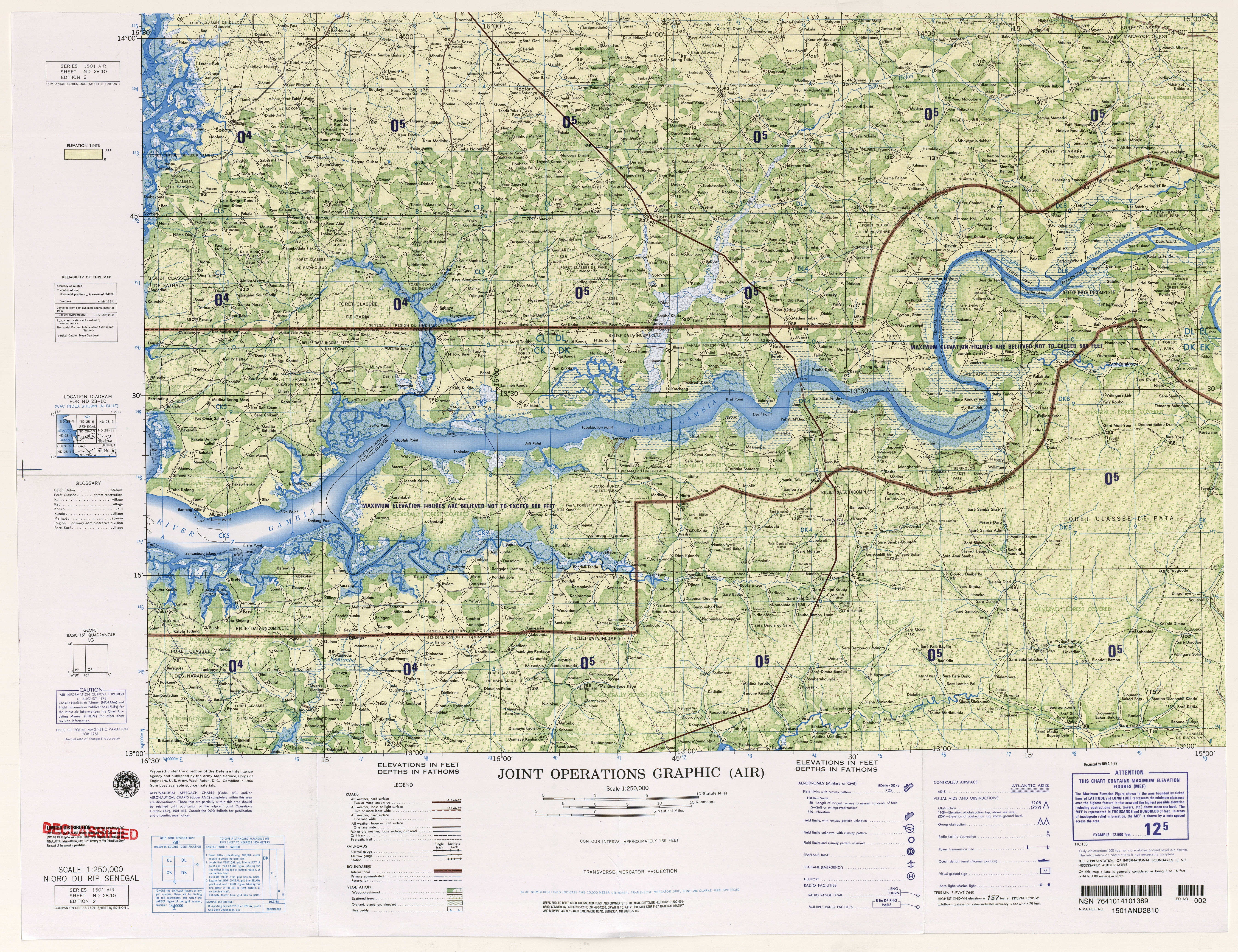
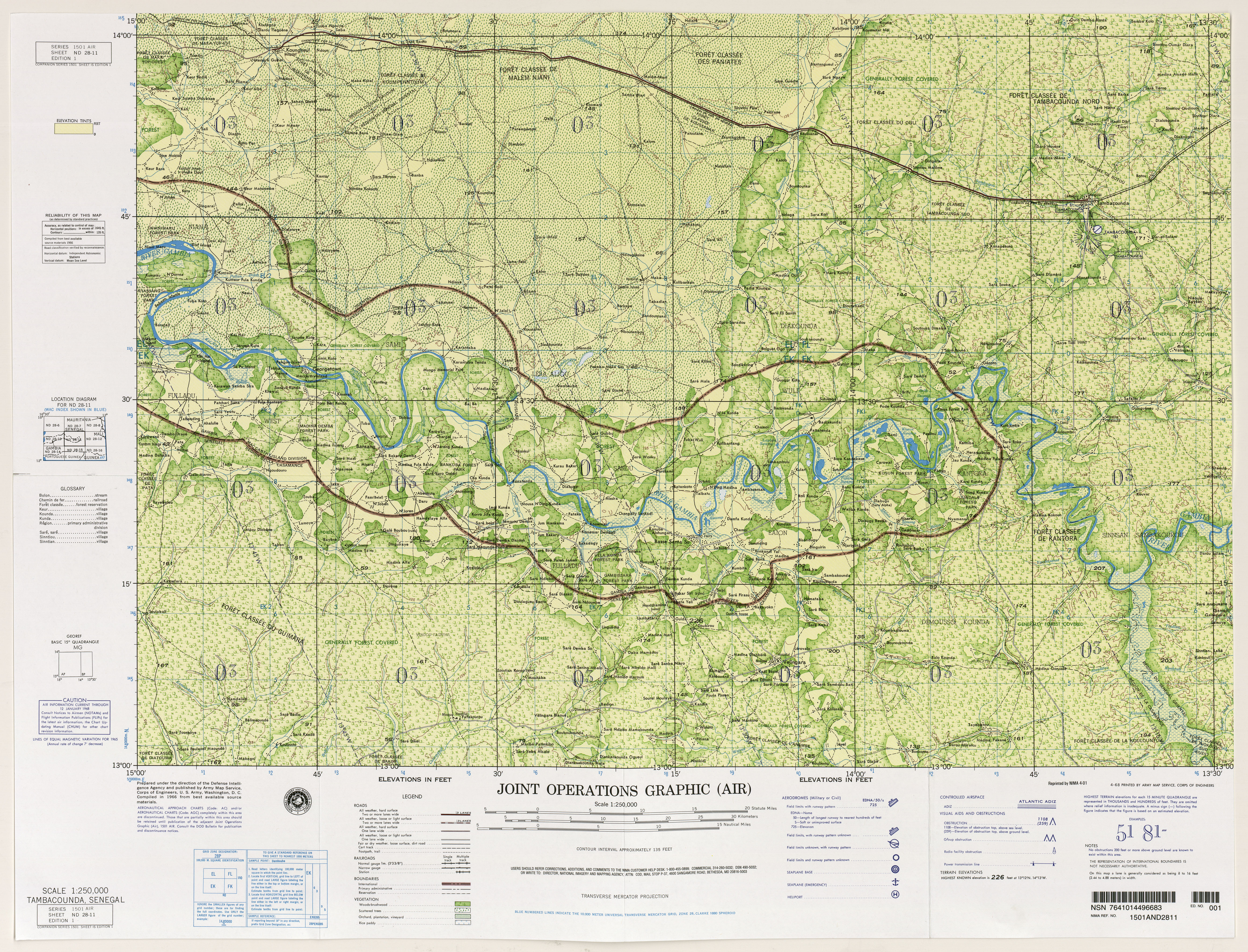
The Gambia River is a major river in West Africa, running 1,120 kilometres (700 mi) from the Fouta Djallon plateau in north Guinea westward through Senegal and The Gambia to the Atlantic Ocean at the city of Banjul. It is navigable for about half that length.

The Truckee River is a river in the U.S. states of California and Nevada. The river flows northeasterly and is 121 miles (195 km) long. The Truckee is the sole outlet of Lake Tahoe and drains part of the high Sierra Nevada, emptying into Pyramid Lake in the Great Basin. Its waters are an important source of irrigation along its valley and adjacent valleys.

The Huron River is a 130-mile-long (210 km) river in southeastern Michigan, rising out of the Huron Swamp in Springfield Township in northern Oakland County and flowing into Lake Erie, as it forms the boundary between present-day Wayne and Monroe counties. Thirteen parks, game areas, and recreation areas are associated with the river, which passes through the cities of Dexter, Ann Arbor, Ypsilanti, Belleville, Flat Rock and Rockwood that were developed along its banks.

The Owyhee River is a tributary of the Snake River located in northern Nevada, southwestern Idaho and southeastern Oregon in the United States. It is 280 miles (450 km) long. The river's drainage basin is 11,049 square miles (28,620 km2) in area, one of the largest subbasins of the Columbia Basin. The mean annual discharge is 995 cubic feet per second (28.2 m3/s), with a maximum of 50,000 cu ft/s (1,400 m3/s) recorded in 1993 and a minimum of 42 cu ft/s (1.2 m3/s) in 1954.
The Little Deschutes River is a tributary of the Deschutes River in the central part of the U.S. state of Oregon. It is about 105 miles (169 km) long, with a drainage basin of 1,020 square miles (2,600 km2). It drains a rural area on the east side of the Cascade Range south of Bend. The Little Deschutes and two other streams in its basin are listed as parts of the National Wild and Scenic Rivers System.

Mattawoman Creek is a 30.0-mile-long (48.3 km) coastal-plain tributary to the tidal Potomac River with a mouth at Indian Head, Maryland, 20 miles (32 km) downstream of Washington, D.C. It comprises a 23-mile (37 km) river flowing through Prince George's and Charles counties and a 7-mile (11 km) tidal-freshwater estuary in Charles County. About three-fourths of its 94-square-mile (240 km2) watershed lies in Charles County, with the remainder in Prince George's County immediately to the north.

Brodhead Creek is a 21.9-mile-long (35.2 km) tributary of the Delaware River in the Poconos of eastern Pennsylvania in the United States.

Broad Run is a tributary of the Potomac River in Loudoun County, Virginia. The creek, located between Goose Creek and Sugarland Run, principally drains portions of eastern Loudoun County, as well as a small portion of western Fairfax County.
Yellow Creek is a tributary of the Pecatonica River in Stephenson County, in the US state of Illinois. The 50 mile (80.5 km) stream also flows through a small part of Jo Daviess County. The waters of Yellow Creek were accessed for water quality in 1996, 28 miles (45.1 km) were listed as "fair" and 22 miles (35.4 km) "good." During the 1832 Black Hawk War the Battle of Waddams Grove was fought along Yellow Creek.
Kiang West National Park is one of the largest and most important wildlife reserves in the Gambia. It was declared a national park in 1987 and is managed by the Gambia Department of Parks and Wildlife Management.

Bao BolongWetland Reserve is a national park in The Gambia. Established in 1996 it covers 220 square kilometres.
Bolon Island Tideways State Scenic Corridor is a state park in the U.S. state of Oregon, administered by the Oregon Parks and Recreation Department. The 11.4-acre (4.6 ha) park is on Bolon Island 10 river miles (16 km) from the mouth of the Umpqua River and north of Reedsport. It is along Highway 101 and near the site, where in 1828, most of Jedediah Smith's party were massacred. The land was given to the state in 1934 by William C. and Jennie D. Chamberlain.

Catherine Creek is a 32.4-mile-long (52.1 km) creek in northeastern Oregon, United States. A tributary of the Grande Ronde River, it is the second-longest stream in the Grande Ronde Valley. Originating in the foothills of the Wallowa Mountains, it flows generally northwest through Catherine Creek State Park and the city of Union before joining the river.
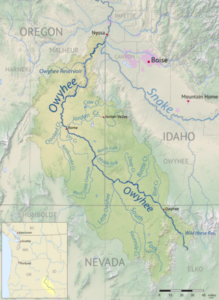
Jordan Creek is a 99-mile (159 km) tributary of the Owyhee River in the northwestern United States. It generally flows west from near Silver City, Idaho, in the Owyhee Mountains to near Rome in the Oregon High Desert. Major tributaries are Big Boulder, Soda, Louse, Spring, Rock, Meadow, Combination, and Louisa creeks in Idaho and Cow Creek in Oregon. The creek is named for Michael M. Jordan, who led a party that discovered gold along the creek in 1863.
Rattlesnake Creek is a tributary, 57 miles (92 km) long, of Crooked Creek in the U.S. state of Oregon. The creek, which is intermittent, begins in the desert north of McDermitt in Malheur County. It joins Crooked Creek southeast of the intersection of U.S. Route 95 and Oregon Route 78 at Burns Junction, about 15 miles (24 km) from the larger stream's confluence with the Owyhee River.

Whychus Creek is a tributary of the Deschutes River in Deschutes and Jefferson counties in the U.S. state of Oregon. Formerly named Squaw Creek, considered derogatory in the 21st century, it was renamed in 2006. Explorer John C. Frémont camped along the stream in 1843 but did not identify it by name. Robert S. Williamson, a surveyor who camped there in 1855, said its Indian name was Why-chus.

Bolon Nature Reserve is the oldest Russian 'zapovednik' in the Russian Far East. It is located on the Middle Amur River lowlands adjacent to the south-west of Lake Bolon. The reserve covers the wetlands of international importance. Large numbers of migratory waterfowl use the area for nesting and stopovers on long flights. The reserve is situated half way between the city of Khabarovsk and Komsomolsk-on-Amur, in the Amursky District of Khabarovsk Krai. The reserve was created in 1997, and covers an area of 100,000 ha (390 sq mi).