
Lake Mweru is a freshwater lake on the longest arm of Africa's second-longest river, the Congo. Located on the border between Zambia and Democratic Republic of the Congo, it makes up 110 kilometres (68 mi) of the total length of the Congo, lying between its Luapula River (upstream) and Luvua River (downstream) segments.

The Luvua River is a river in the Katanga Province of the Democratic Republic of the Congo (DRC). It flows from the northern end of Lake Mweru on the Zambia-Congo border in a northwesterly direction for 350 kilometres (220 mi) to its confluence with the Lualaba River opposite the town of Ankoro. The Lualaba becomes the Congo River below the Boyoma Falls.
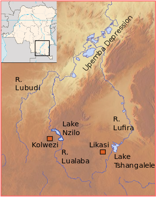
The Lubudi River is a tributary of the Lualaba River in the Democratic Republic of the Congo (DRC). The Lubudi rises near the Zambian border southwest of Kolwezi. It flows north and northeast to join the Lualaba from the left where the southern Katanga plateau drops into the Upemba Depression, near Bukama.

The Lukuga River is a tributary of the Lualaba River in the Democratic Republic of the Congo (DRC) that drains Lake Tanganyika. It is unusual in that its flow varies not just seasonally but also due to longer term climate fluctuations.
The Ulindi River is a tributary of the Lualaba River in the Democratic Republic of the Congo (DRC). There is a proposal to build a hydroelectric power plant on the river to power a gold mining project.

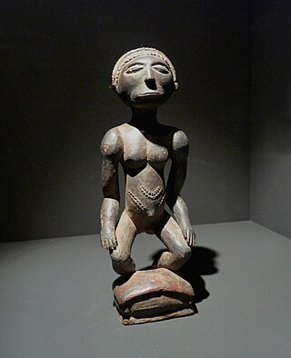
The Luba people or Baluba are an ethno-linguistic group indigenous to the south-central region of the Democratic Republic of the Congo. The majority of them live in this country, residing mainly in Katanga, Kasai and Maniema. The Baluba Tribe consist of many sub-groups or clans who speak various dialects of Luba and other languages, such as Swahili.

Kazembe is a traditional kingdom in modern-day Zambia, Southeastern Congo. For more than 250 years, Kazembe has been an influential kingdom of the Kiluba-Chibemba, speaking the language of the Eastern Luba-Lunda people of south-central Africa. Its position on trade routes in a well-watered, relatively fertile and well-populated area of forestry, fishery and agricultural resources drew expeditions by traders and explorers who called it variously Kasembe, Cazembe and Casembe.

Manono is a town and territory in Tanganyika Province, Democratic Republic of the Congo.

The Kingdom of Luba or Luba Empire (1585–1889) was a pre-colonial Central African state that arose in the marshy grasslands of the Upemba Depression in what is now southern Democratic Republic of Congo.

Pweto is a town in the Haut-Katanga Province of the Democratic Republic of the Congo (DRC). It is the administrative center of Pweto Territory. The town was the scene of a decisive battle in December 2000 during the Second Congo War which resulted in both sides making more active efforts to achieve peace. Pweto and the surrounding region were devastated during the war. As of 2011 little had been done to restore infrastructure or rebuild the economy. The town is served by Pweto Airport.
Pweto Territory is a territory in the Haut-Katanga Province of the Democratic Republic of the Congo (DRC). The headquarters are in the town of Pweto.
Moba Territory is a territory in the Tanganyika Province of the Democratic Republic of the Congo. The administrative center is Moba port. The territory has an estimated area of 24,500 square kilometres (9,500 sq mi) and a population of almost 610,000.
The Holoholo also known as Kalanga are a Bantu ethnic group that inhabit the shores of central lake Tanganyika. The majority of them live near Kalemie city on Lake Tanganyika in Tanganyika Province of the Democratic Republic of the Congo, and on the opposite shore of the lake in Uvinza District of Kigoma Region in Tanzania.
Ilunga Sungu was a ruler (Mulopwe) of the Kingdom of Luba in what is now the Katanga Province of the Democratic Republic of the Congo, said to have reigned from about 1780 to his death.
The Hemba people are a Bantu ethnic group in the Democratic Republic of the Congo (DRC).
The Elila River is a tributary of the Lualaba River in the Democratic Republic of the Congo. It rises in Mwenga Territory of Sud-Kivu Province and flows west through Shabunda Territory and then Pangi Territory in Maniema Province, entering the Lualaba just downstream of Kindu.

The Lega people are a Bantu ethnic group of the Democratic Republic of the Congo. In 1998 their population was about 250,000.
Géomines was a Belgian mining company active in the Belgian Congo and then in the Democratic Republic of the Congo. It was established in 1910, and exploited a large deposit in the southeast of the country to become one of the largest tin producers in the world. It was taken over by Zairetain in 1968.
Cominière was a Belgian holding company active in the Belgian Congo. It was involved in plantations, forestry, mining, railways and other activities. The Congo assets were nationalized when the Democratic Republic of the Congo became independent in 1960. What remained of Cominière was acquired by Lonhro in 1971.
Piana–Mwanga Hydroelectric Power Station, also Mpiana–Mwanga Hydroelectric Power Station, is a 54 megawatts (72,000 hp) hydroelectric power station in the Democratic Republic of the Congo. The power plant was originally commissioned in 1933 to service a nearby tin mine. The tin mine was mothballed in 1982 and so was the power station. In 2020, the mining conglomerate AVZ Minerals Limited, reached an agreement to rehabilitate the power station to power its mining operations in Manono Territory, including the Manono–Kitotolo Mine, one of the largest lithium mines in the DRC, whose reserves are estimated at 120,000,000 tonnes of ore.
