
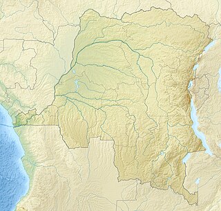
The Congo River, formerly also known as the Zaire River, is the second longest river in Africa, shorter only than the Nile, as well as the second largest river in the world by discharge volume, following only the Amazon. It is also the world's deepest recorded river, with measured depths in excess of 220 m (720 ft). The Congo-Lualaba-Chambeshi River system has an overall length of 4,700 km (2,920 mi), which makes it the world's ninth-longest river. The Chambeshi is a tributary of the Lualaba River, and Lualaba is the name of the Congo River upstream of Boyoma Falls, extending for 1,800 km (1,120 mi).
Gold deposits at Moto were initially discovered in 1903 and mining began in 1905. A colonial state corporation called Kilo-Moto exploited the deposits from 1905 to 1919. The colonial state recruited laborers from rural Africa to work in the mines. In 1919, Kilo-Moto became organized as an autonomous colonial state corporation with a Board of Directors in Brussels appointed by the Minister of the colonies. This company operated as a private corporation starting in 1926 and survived the handover to independent Congolese rule in 1961, but was taken over by the Zairian state in 1967. The archives of the company up to 1967 are still stored in Brussels.

Haut-Congo Province was a province of the Republic of the Congo (Léopoldville), now the Democratic Republic of the Congo. It was formed in April 1962 from part of the Orientale Province. In 1966 it was merged back into the reconstituted Orientale Province.

Kilo-Moto is a region in the far northeast corner of the Democratic Republic of the Congo (DRC) where gold was discovered in the Ituri River by government prospectors in 1903. Moto is in the Haut-Uélé Province and Kilo in the Ituri Province.
Watsa Territory is an administrative area in the Haut-Uele province of the Democratic Republic of the Congo. The administrative center is the town of Watsa.

Ituri District, later Kibali-Ituri District, was a district of the Belgian Congo and the Democratic Republic of the Congo. It roughly corresponded in area to the present Ituri Province.

Haut-Uele District was a district of the Belgian Congo and the Democratic Republic of the Congo. It was formed from part of Uele District in 1912. It roughly corresponded in area to the present Haut-Uélé province.

Bas-Uele District was a district of the Belgian Congo and the Democratic Republic of the Congo. It was formed from part of Uele District in 1912. Later it was merged back into Uele District, then split out again. There were various boundary changes. It roughly corresponded in area to the present Bas-Uélé province.
The Kibali Gold Mine is a combined open pit and underground gold mine in the Haut-Uélé province of the northeast Democratic Republic of the Congo. By area, it is one of the largest in Africa. The mine is named for the nearby Kibali River.
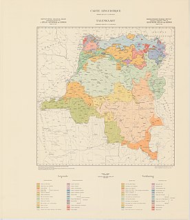
The Districts of the Belgian Congo were the primary administrative divisions when Belgium annexed the Congo Free State in 1908, each administered by a district commissioner. In 1914 they were distributed among four large provinces, with some boundary changes. In 1933 the provinces were restructured into six, again with boundary changes. The number of districts fluctuated between 12 and 26 through splits and consolidations, first rising, then falling, then rising again.

Stanleyville District was a district of the Belgian Congo and Democratic Republic of the Congo. It went through various changes in extent. Between 1933 and 1963 it had roughly the same extent as the current Tshopo province.
Uele District was a district of the Congo Free State and the Belgian Congo. It roughly corresponded to the current provinces of Bas-Uélé and Haut-Uélé.
The Itimbiri River is a right tributary of the Congo River, which it joins above Bumba. At one time it was important as a navigable waterway for transporting good from the northeast of the country down to the Congo.

The Chinko River is a river of the Central African Republic. It is a right tributary of the Mbomou River.
Ekwangatana is the location of a post established by Belgian officers in what is now Bas-Uélé province in the Democratic Republic of the Congo.
The Gada River is a left tributary of the Uele River, which it joins downstream from Niangara in the Haut-Uélé province of the Democratic Republic of the Congo.
The Barambu are an ethnic group who live in the northeast of the Democratic Republic of the Congo.
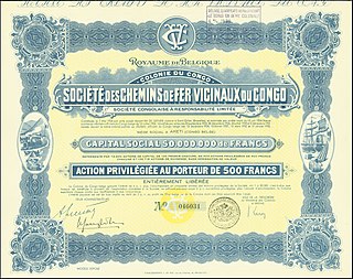
The Société des Chemins de Fer Vicinaux du Congo was a railway company that operated the narrow gauge Vicicongo line and provided trucking services in the northeast Belgian Congo, and then in the Democratic Republic of the Congo between 1924 and 1974. It provided transport for agricultural goods produced in the northeast that were shipped on the Congo River to Léopoldville (Kinshasa). After independence in 1960 there were civil disturbances and the railway was poorly maintained. The company was taken over by the state in 1974. Later there were further disturbances in which the stations were destroyed and the rolling stock used as a source of metal. The track is decrepit and no longer usable.
Cominière was a Belgian holding company active in the Belgian Congo. It was involved in plantations, forestry, mining, railways and other activities. The Congo assets were nationalized when the Democratic Republic of the Congo became independent in 1960. What remained of Cominière was acquired by Lonhro in 1971.
This page is based on this
Wikipedia article Text is available under the
CC BY-SA 4.0 license; additional terms may apply.
Images, videos and audio are available under their respective licenses.
