
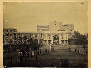
Shaniwar Wada is a historical fortification in the city of Pune, India.
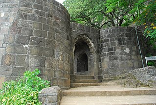
Shivneri Fort is a 17th-century military fortification located near Junnar in Pune district in Maharashtra, India. It is the birthplace of Chhatrapati Shivaji Maharaj, the emperor and founder of Maratha Empire.

Gingee Fort or Senji Fort in Tamil Nadu, India is one of the surviving forts in Tamil Nadu, India. It lies in Villupuram District, 160 kilometres (99 mi) from the state capital, Chennai, and is close to the Union Territory of Puducherry. The site is so fortified that Shivaji, the Maratha king, ranked it as the "most impregnable fortress in India", and it was called the "Troy of the East" by the British. The nearest town with a railway station is Tindivanam and the nearest airport is Chennai (Madras), located 150 kilometres (93 mi) away.
Wai is a town in Satara district of Maharashtra state in India. Located on the Krishna River, Wai was a prominent town during the Peshwa era. Two important Maratha Brahmin from ruling families had their origins here: Rani Lakshmibai of Jhansi and Gopikabai, wife of Nanasaheb Peshwa.

Satara district is a district of Maharashtra state in western India with an area of 10,480 km2 (4,050 sq mi) and a population of 3,003,741 of which 14.17% were urban. Satara is the capital of the district and other major towns include Medha, Wai, Karad, Koregaon, Maan, Koynanagar, Rahimatpur, Phaltan, Mahabaleshwar, Vaduj and Panchgani. This district comes under Pune Administrative Division along with Pune, Sangli, Solapur and Kolhapur. The district of Pune bounds it to the north, Raigad bounds it to the north-west, Solapur the east, Sangli to the south, and Ratnagiri to the west.
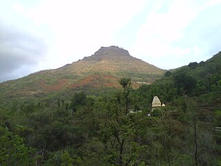
Mangalgad, also known as Kangori, is a fort in Maharashtra near the village of Dudhanewadi. Kangori, or Mangalgad Fort, is in the Mahad sub-division about eleven miles (18 km) east by south from Mahad town.
Patan is a census town in Satara district in the Indian state of Maharashtra.

Kinhai is a village located in Koregaon Taluka, Satara District in Maharashtra, India. The village is divided into Pantanchi Kinhai on the western side and Peth Kinhai to the east. It is located 7 miles (11 km) north of Koregaon, at 2,320 ft (710 m) above sea level. As of the 2011 Indian census, Kinhai had a population of 3,360.

The Battle of Koregaon was fought on 1 January 1818 between the British East India Company and the Peshwa faction of the Maratha Confederacy, at Koregaon Bhima.
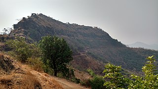
Kamalgad, also called Bhelanja or Kattalgad is a square hill fort in Wai Taluka in Maharashtra, India.

Visapur Fort is a hill fort near Visapur village in Maharashtra, India. It is a part of the Lohagad-Visapur fortification.
Maan is not a city name. Dahiwadi taluka is called as Maan taluka because land it's situated on Maan river that reason it's called Maan.Sub division dahiwadi is in Satara district of Maharashtra in India. Dahiwadi is tehsil place of maan taluka.
Bhadra Fort is situated in the walled city area of Ahmedabad, India. It was built by Ahmad Shah I in 1411. With its well carved royal palaces, mosques, gates and open spaces, it was renovated in 2014 by Ahmedabad Municipal Corporation (AMC) and Archaeological Survey of India (ASI) as a cultural centre for the city.

Vardhangad Fort {वर्धनगड} lies on the Bhadle-Kundla spur of the Mahadev range at a point of it on the boundary between the Koregaon and Khatav Talukas, seven miles north-east of Koregaon and nine miles north-east of Satara.
Mahimangad Fort, in Maan lies within the village limits of Mahimangad village about five and a half miles west of Dahivadi.
Pandavgad Fort), 4177 feet above sea level, lies four miles north-west of Wai. The fort is conspicuous over a low spur branching east from its southern angle. From a distance it appears a square fortification with natural escarpment of cut black stone. The fort can be reached by a footpath diverting to the north from Bhoganv, a village 3 miles west of Wai on Wai -Velang State Transport route. In Bhoganv village, there is a small memorial of Vaman Pandit, the celebrated Sanskrit poet of the 15th century. The approach to the fort is very difficult and at places the path is barely a foot in width with the hill slopes on one side and deep valleys on the other. Hill though not covered with thick forest has a considerable foliage of bushy shrubs. A path from Bhogaon leads to small break in the above-mentioned spur and from this break it continues by a shoulder of the hill, on which are few huts belonging to Kolis formerly connected with the fort and charged with attendance on the temple. The ascend from the Koli hills is steepish and for the last two hundred yards had steps cut in stone. At the northern end the path reaches the entrance gate which now consists of two broken pillars of enormous size. It had a single archway with apparently no door. The fort is about six acres in extent and nearly a square. Its defences consist of a scarp generally from forty to sixty feet high, more than usually precipitous and in many places actually overhanging and surmounted by a wall with masonry ramparts. The original materials of enormous blocks of dry stone have nearly all disappeared and except the northern end where the gateway and wall are of the huge masonry of the old forts what remains is very light work. Of the 18 ponds which supplied the garrison with water, only three possess water. On the top a large pond on the eastern part is silted up. To the north of the main gate, some 150 feet down the shoulder of the hill is a group of small ill maintained rock cut water cisterns. All the buildings on the fort excepting that of the temple of Pandjaidevi are in a state of complete ruin. The temple is built in local stone masonry and is not in any way imposing. A hall in front of the shrine of devi measures about 30'X20' and has a flat roof supported on four pillars. Number of ancient buildings on the fort have been reduced to a mere heap of bricks. In the centre, remains of the main building are hidden by a thick growth of bushy shrubs. The fort commands an excellent view of the surrounding area. To the east one gets a bird's eye view of Wai, and Mandhardev stands conspicuously about 4 miles to the north-west. To the west Kenjalgad marks a prominent object at a distance of about 5 miles.
Varugad Fort , in Man lies, as the crow flies, about twelve miles north-west of Dahivadi, within the limits of Panvan village. The best way to it is to camp at Pingli Budrukh four miles south-west of Dahivadi and to travel thence by the Tasganv-Mograla road for about ten miles to Jadhavvadi, a hamlet of Bijvadi village lying almost a quarter of a mile east and within sight of the road; from here a well marked track due west goes to the village of Tondle, and from Tondle a path leads direct to the fort over rough ground broken but perfectly passable by a pony, and skirting the northern base of the long plateau of Panvan. The direction of the path is generally a little north of west and it crosses innumerable small ravines and water-courses which lead through rough hill tracts to the edge of the plateau of which the Man taluka chiefly consists. These streams pour down the bare sides of the main hill range, here some 1,000 to 1,500 feet high, on to the plain of Girvi adjoining the Phaltan taluka. The country all the way from Pingli is terribly bare and rocky. Here the stony hills and ravines are interrupted by fairly level plateaus with tolerable soil and good sites for cultivation and grazing. A few small deer and chinkharawill probably be seen, while cattle are everywhere browsing in considerable numbers. Three hamlets, one of them known as Ghodavadi, are reached, and some well-to-do cultivators will probably meet the visitor and turn out to be Gadkaris or descendants of the ancient hereditary fort garrison. The hamlet is situated on a projection between the two ravines, and has been built on a hill of a truncated conical shape. The hill rises about 250 feet above the level of the plateau, which itself constitutes the summit of the Mahadev range at this point. The cone with the walls on it is seen from a great distance and appears very small indeed. But on near approach it is seen to be but the inner citadel of a place of considerable size and strength for the times in which it was built. On the south-west the outer wall or enceinte is entered by a rude gateway of a single pointed arch about eight feet high and five feet broad. As usual there is a curtain of solid masonry inside. The gate lies about 150 yards east of the edge of the plateau, which there terminates in an almost unbroken vertical precipice of several hundred feet in height and receding in a north-easterly direction. No wall was built along about three hundred yards of this part which is absolutely unscalable, but for the rest of the way the walling is continued along the edge of the cliff in a north-east direction for about another three hundred yards. Here it turns still following the cliff to the south-east for another seven hundred yards, and then gradually rounds to the westward covering four hundred and fifty yards more till it meets the gateway. But for the break of the inaccessible precipice this outer wall would form a nearly equilateral triangle with the corners rounded off, the side being of some six hundred and fifty yards. Facing nearly north, about fifty yards from the north-east angle, is a gateway with a couple of curtains in solid masonry. This entrance is cut in the sides of the cliff about twenty feet below the top which is reached by some dozen steps. It consisted as usual of a pointed arch, the top fallen in, about ten feet high by five broad. It leads out to the path down to Girvi, a village in the plains below and it probably formed the communication with Phaltan. This road winds down the face of the range for some five hundred feet till it hits the shoulder of a spur which it then follows to the base. The walling on the south side, from the edge of the cliff to some hundred yards east of the southern gate, is not more than a couple of feet in thickness and consists of all-fitting stones unmortared. The rest is massive and well mortared and still fairly preserved. The average height is from seven to ten feet. In the south-east angle is a rude temple of Bhairavnath and a few houses with the remains of Man y more. On the right side of the southern gate is a well preserved stone pond about thirty yards square with steps leading down to it. Next to and on the north of Bhairavnath's temple is another pond. The way up to the fort proper or upper and lower citadels is from the north side. The path up the hill side, which is steep but with grass and soil left in Man y places, is almost destroyed. About 150 feet up is the outer citadel built on a sort of shoulder of the hill and facing almost due west. It contains two massive bastions of excellent masonry looking north-west and south-west so that guns planted on them could comMan d respectively the north and south gateways. This citadel was connected with the main wall by a cross wall running across the whole breadth of the fort from east to west. Its entrance lies close below that to the upper citadel. A masonry curtain projects so as to hide the arch itself, which is not more than seven feet high by three broad, and has to be entered from due east. On the south side the walls are carried right up to the scarp of the upper citadel and are some ten feet high, so that to take the lower citadel in rear or flank must have been difficult. The upper citadel is above a vertical scarp some thirty feet high. The entrance to it lies some thirty feet above that to the lower citadel, and is cut in the rock about eight feet wide. There is a gateway of a pointed arch with the top fallen in and twenty odd steps leading up to it and ten more cut out of the rock, and winding up past the inside curtain on to the top. The walls of this upper citadel are still in tolerable preservation. They were originally about ten feet high and built of fair masonry. There is a large turret on the south-west corner, evidently meant to comMan d the southern gate. About ten yards to the east of this turret is a new looking building which was the headquarters or sadar. Immediately east of this and below it is a great pit about thirty feet square and equally deep roughly cut in the rock and said by the people to be a dungeon. Next to it on the south is a small pond evenly cut and lined with mortar used for storing water. There are some remains of sepoys' houses, and, near the turret, a small stone wheel said to belong to a gun. The outer walls east of the gates have bastions at every turn of the cliffs, and the masonry here is particularly strong and well preserved. It would appear that attacks were dreaded chiefly from the plain below. The assailants could either come up the spur towards the north entrance or they might attempt the spurs on the other side of the eastern ravine and attack the southern gateway. Hence apparently the reason for strengthening the walls of the enceinte on this side. After passing the southern gateway the assailants would be comMan ded from the lower citadel. They Would then be encountered by the cross wall. If that obstacle was overcome the besieged would run round the east side and into the two citadels. The appearance from the fort of the plain in the north is most formidable. The Panvan plateau completely comMan ds and indeed almost overhangs it. The fort is believed to have been built by Shivaji to resist the Moghals whose attacks he must have dreaded from the plain below. The Karkhanis or Superintendent of the fort was a Prabhu. The fort garrison consisted of 200 Ramoshis, Mahars, and other hereditary Gadkaris besides sepoys. It was surrendered in 1818 to Vitthal Pant Phadnis of the Raja of Satara left in charge of the town. He detached 200 men to take possession, being part of a force then raised to protect the town from the enterprizes of Bajirav's garrisons then in the neighbourhood. [Elphinstone in Pendhari and Maratha War Papers, 245.]
Rasalgad is a fort in the Maharashtra state of India. It lies 15 km east of Khed City. The fort has been developed as tourist attraction. Its fortification in good condition. The fort lied on a south end of a narrow spur which joins with Suamargad and Mahipatgad in the north direction. In 2003 the fort was declared a protected monument by the Archaeological Survey of India.

Tringalwadi fort is located in the Igatpuri taluka of Nashik district. It is located on the ancient trade route passing through Thal ghat. The fort is located near village Tringalwadi. The Tringalwadi irrigation dam which is close to the village was built in 1978.

Peb Fort / Vikatgad Fortis a fort located 19 km (12 mi) from Karjat, in Raigad district, of Maharashtra. This fort is in continuation with the Malang gad, Tauli Hill and Chanderi fort of the Matheran Hill Range. Vikatgad is a favourite destination for one-day trekkers. The trek path to Vikatgad is along deep ravines and cliffs. Its closeness to Matheran and Neral attracts many trekkers on weekends. The forest department and local villagers are doing plantation and some restoration works on the fort.

