Related Research Articles
Kalsubai is a mountain in the Western Ghats, located in the Indian state of Maharashtra. Its summit, situated at an elevation of 1,646 metres (5,400 ft), is the highest point in Maharashtra.

Harishchandra Fort is a hill fort in the Ahmednagar district of India. Its history is linked with that of Malshej Ghat, kothale village and it has played a major role in guarding and controlling the surrounding region.
Igatpuri is a town and a Hill Station. It is also a municipal council in Nashik District in the Indian state of Maharashtra. It is located in the Western Ghats. Igatpuri railway station lies in Nashik District between Mumbai and Nashik Road on the Central Railway. Igatpuri is known for Vipassana International Academy, where ancient technique of meditation is taught called Vipassana. The place is one of the best places to visit in Maharashtra in monsoon. It is a hill station on busy Mumbai-Agra NH-3 only 45 km from Nashik and 130 km from Mumbai.

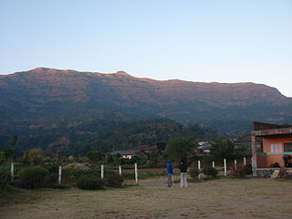
Bhandardara is a holiday resort village near Igatpuri, in the western ghats of India. The village is located in the Akole tehsil, Ahmednagar district of the state of Maharashtra, about 185 kilometers (115 mi) from Mumbai and 155 kilometers (96 mi) from Ahmednagar.
Salher is a place located near Waghamba in Satana tehsil in Nashik district of Maharashtra, India.The old name of Salher was Gavalgarh, which was based on the name of the local Bhil king named Gaval Bhil, he was the discoverer of this place. It is the site of the highest fort in the Sahyadri mountains and the second highest peak at 1,567 metres (5,141 ft) after Kalsubai in Maharashtra and 32nd highest peak in Western Ghats. This was one of the celebrated forts of the Maratha Empire. The money acquired after raiding Surat was brought to this fort first on its way to the Maratha capital forts.
Akole is a city and Taluka in Akole tehsil, Ahmednagar district in the state of Maharashtra, India. Akole is surrounded by the Sahyadri Mountains of Western Ghats, India. Several historical sites in the city honor Akole's connection to the history and culture of Maharashtra.

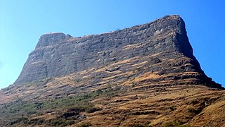
Ratangad is a fort in Ratan Wadi, Maharashtra, India, overlooking the locale of Bhandardara, one of the oldest artificial catchment area. This fort is located in the Ahmadnagar district of Maharashtra. It is on the boundary of Ahmadnagar and Thane districts. The fort is about 400 years old. This fort is often covered with flowering plants in November. Ratangad is also called Jewel of the Sahyadris.

Shrivardhan Fort is one of the two hill forts that constitute the Rajmachi fortification, the other being Manaranjan Fort. It is located in Rajmachi village which 8.5 km from Lonavala in the Sahyadris mountain range. At 900 m(3000 feet) above sea level it was the taller of the two peaks and was named after Shrivardhan Ganpatrao Patwardhan. Other than a rampart there is no visible construction. It was probably used at a watchtower for the Sahyadri region. There are two water tanks at the top of the hill but one of them has an iron pillar in it.
Madangad is a fort in the Nashik region of Maharashtra, India in the Kalsubai range.
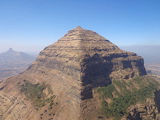
Dhodap, is one of the hill forts in Maharashtra state in India. Situated in Chandwad taluka in the Nashik district. the fort is 4829 ft above sea level. It is the site of the second highest fort in the Sahyadri mountains after Salher. Dhodap hill is the second highest hill peak in Maharashtra after Kalsubai and Salher and the 29th highest peak in Western Ghats.

Alang Fort is a fort located in the Kalsubai range of the Western Ghats mountains, Nashik,. Alang Fort, Madangad Fort, Kulang Fort, and the trek connecting them are known as Alang, Madan, and Kulang (AMK). Alang Fort is regarded as one of the most difficult places to reach in the region. As the Maharashtra Culture Government website notes, "Alang-Madan-Kurland is one of Maharashtra's most challenging treks, especially because of its challenging stretches of water and dense forests." This route is suitable for experienced mountaineers. While the forts are difficult to access because of heavy local rains and poorly marked trails, they remain a popular tourist destination.
Ghanchakkar 1,532 metres (5,026 ft) is the third highest peak in the Maharashtra State under Sahyadri mountain ranges in western India. Its neighbouring peak Muda 1,520 metres (4,990 ft) is the fourth highest peak in the Maharashtra State under Sahyadris.

Brahmagiri is a mountain range in the Western Ghats of Maharashtra. It is situated in Nashik District in the Indian state of Maharashtra. Trimbakeshwar Shiva Temple is located near this place. The origin of the sacred Godavari river is near Trimbak. It flows for 1,465 kilometres (910 mi), first eastwards across the Deccan Plateau then turns southeast, entering the West Godavari district and East Godavari district of Andhra Pradesh, until it splits into two watercourses that widen into a large river delta and flow into the Bay of Bengal.
Dhak Bahiri is a cave in the Sahyadri hill range, situated near the village Jambhivli off village-Malavali in the Pune district of India. It was used by pilgrims and sages for the pilgrimage to the god Bahiri.
Nhavigad is also called as Nhavagad or Ratangad. It is located in the Baglan area of Nashik district. There are two main hill ranges in Baglan area the Selbari range and Dholbari range. These two ranges run parallel to each other in east-west direction. Nhavigad is located in Selbari mountain range. All these forts were maintained to keep watch on the Burhanpur-Surat ancient commercial road. The road passes between the two hill ranges. Nhavigad is a small fort, but very difficult to climb.
Indrai Fort / Indragiri Fort is a fort located 75 km from Nashik, in Nashik district, of Maharashtra. This fort though is an important fort in Nashik district but, it is less visited by the trekkers. In Chandwad taluka, there are 4 forts in a line on the Satmal hill range, the Chandwad fort, Indrai fort, Rajdher fort, and Koldher fort. This fort is easy to climb but requires 3 hours to reach the fort.
Rajdeher Fort (Marathi: राजधेर किल्ला) is a fort located 10 km (6.2 mi) from chandwad, Nashik district, of Maharashtra. This fort is an important fort in Nashik district.

Gorakhgad Fort is a fort located 24 km from Murbad, Thane district, of Maharashtra. This fort is an important fort in Thane district. This fort was mainly used by sadhus or hermits for meditation.and also by local people's of surrounding village, It was also used to guard the ancient trade route passing through Naneghat.
Padargad is a small fort used for vigilance in the past. is situated to the east of Karjat in the Indian state of Maharashtra. It is on the Bhimashanker trek route in the Karjat area, because of its height and difficult climbing, it is not visited by most of the trekkers.
Bitangad Fort is a fort in Nashik district in the Igatpuri taluka in Maharashtra state of India.
References
- ↑ Pankaj (2011-11-19). "Ratangad Bhandardara Trek: Bhairavgad testing skills of hardcore trekkers". Ratangad Bhandardara Trek. Retrieved 2020-01-02.