
Jufureh, Juffureh or Juffure is a town in the Gambia, 30 kilometers inland on the north bank of the River Gambia in the North Bank Division near James Island. The town is home to a museum and Fort Jillifree.

The Tapi river is the longest river in southern Thailand. The river originates at Khao Luang mountain in Nakhon Si Thammarat Province, and empties into the Gulf of Thailand at Bandon Bay near the town of Surat Thani. It has a length of 230 kilometres (140 mi).
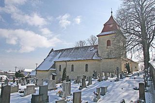
Turkovice is a village in the Pardubice Region of the Czech Republic. It has around 260 inhabitants.
Bayan-Önjüül is a sum of Töv Province in Mongolia. The Baraat settlement is 30 km SE from Bayan-Önjüül sum center.

The Yugoslav motorcycle Grand Prix was a motorcycling event forming part of the Grand Prix motorcycle racing season from 1970 to 1990.

Robotno-Fitowo is a village in the administrative district of Gmina Zbiczno, within Brodnica County, Kuyavian-Pomeranian Voivodeship, in north-central Poland. It lies 5 kilometres (3 mi) north of Zbiczno, 15 km (9 mi) north of Brodnica, and 64 km (40 mi) north-east of Toruń.
Gawin is a village in the administrative district of Gmina Chodecz, within Włocławek County, Kuyavian-Pomeranian Voivodeship, in north-central Poland.

Kachigawa Station is a railway station in Kasugai, Aichi Prefecture, Japan.

Qasımlı is a village in the Agdam Rayon of Azerbaijan.
Maciejów is a village in the administrative district of Gmina Zduńska Wola, within Zduńska Wola County, Łódź Voivodeship, in central Poland.

Wymysłów is a village in the administrative district of Gmina Działoszyce, within Pińczów County, Świętokrzyskie Voivodeship, in south-central Poland. It lies approximately 4 kilometres (2 mi) north-east of Działoszyce, 19 km (12 mi) south-west of Pińczów, and 57 km (35 mi) south of the regional capital Kielce.
Jaźwiny is a village in the administrative district of Gmina Krasne, within Przasnysz County, Masovian Voivodeship, in east-central Poland. It lies approximately 8 kilometres (5 mi) south-west of Przasnysz and 83 km (52 mi) north of Warsaw.
Straszyn is a settlement in the administrative district of Gmina Myślibórz, within Myślibórz County, West Pomeranian Voivodeship, in north-western Poland.

Razgojna is a village in the municipality of Leskovac, Serbia. According to the 2002 census, the village has a population of 904 people.
Staatsliedenbuurt (Amsterdam) is a neighborhood of Amsterdam, Netherlands.
Lepiksaare is a village in Mustvee Parish, Jõgeva County in northeastern Estonia.
Pulli is a village in Saaremaa Parish, Saare County in western Estonia.
Rusce is a village in the municipality of Vranje, Serbia. According to the 2002 census, the village has a population of 73 people.
Souk El Had is a town and commune in Relizane Province, Algeria.
Hanlyo University is a university located in Gwangyang, South Korea.


