Akole taluka | |
|---|---|
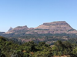 Kalad Gadh | |
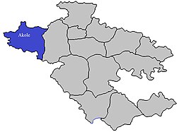 Location of Akole in Ahmednagar district in Maharashtra | |
| Coordinates: 19°32′32.06″N74°0′19.88″E / 19.5422389°N 74.0055222°E | |
| Country | |
| State | Maharashtra |
| District | Ahmednagar |
| Headquarters | Akole |
| Government | |
| • Lok Sabha constituency | Shirdi (Lok Sabha constituency) |
| • Assembly constituency | Akole (Vidhan Sabha constituency) |
| • MLA | Dr. Kiran Yamaji Lahamate |
| Area | |
• Total | 1,505.0 km2 (581.1 sq mi) |
| Population (2011) | |
• Total | 291,950 |
| • Density | 193.99/km2 (502.42/sq mi) |
| Demographics | |
| • Literacy rate | 74.86% |
| • Sex ratio | 974 |
| Rain | 1058 mm |
| Website | www |
Akole taluka is a taluka in Ahmednagar district in Maharashtra state of India. [1] Akole consists of many places like Harishchandragad, Kalsubai, Bhandardara (Wilson) Dam, Sandhan Valley, Vishramgad etc. which attract tourists. Akole is not only famous for its natural scenery but, many historical events are also associated with it. The Western Akole is a part of Sahyadri ranges which increase its important.
